Fájl:African-civilizations-map-pre-colonial.svg
Az oldal más nyelven nem érhető el.
A Wikipédiából, a szabad enciklopédiából

Eredeti fájl(SVG fájl, névlegesen 1 390 × 1 295 képpont, fájlméret: 488 KB)

 
W3C-validity not checked.

Összefoglaló

Leírás

Africa History Atlas

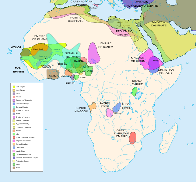
Diachronic map showing pre-colonial cultures of Africa (spanning roughly 500 BCE to 1500 CE)

This map is "an artistic interpretation" using multiple and disparate sources.
Dátum
Forrás A feltöltő saját munkája
Szerző Jeff Israel (ZyMOS)
Más változatok

Származékos művek:  African-civilizations-map-imperial.png

Civilizations

These civilizations are shown on the map above

Mali Empire (done):
        [4], [5], [6], [7], [8](1300), 14

Nok Culture(done):
        http://perso.orange.fr/miltiade/Civilisation_de_Nok.htm
        [5]

Fulani empire (aka sokoto empire, Sokoto Calphate, Fulani Empire of Sokoto)  (fulani people are different) (done):
        [2], [10e], [11e]
Akan States (generric term for states with the akan people)(Done): 
 [7], 
Benin: (done)
        [7],[14],[16]
Hausa (done)
        [7], [10],[16]

Kingdon of Kangaba (1000AD?) (done)
        [8](1235)

Christian Ethiopia(done)
        [5]

Songhai Empire (done)
        http://commons.wikimedia.org/wiki/Image:Mapa_shonghai.svg
        [3], [4], [5], [6], [7], [8](1300), [16]
        http://www.zum.de/whkmla/histatlas/westafrica/haxmali.html
        http://empathosnationenterprises.com/Consulate/EN-Library/Black-Studies/afempire.html

Empire of Ghana (done):
        [4], [5], [6], [7]

Wolof: (15th century) (done)
        [2],[2c],[14]

Empire of Kanem:(done)
        [15]

Fatimid caliphate(done) 909-1171AD
        [2b],[6b]

Ayyubid dynasty (done) 1171-1250ad
        [1b], [5e], [6e]

Umayyad Caliphate (done) 661-750
        [5b]

Yoruba yorubaland    (done)
        [4b],[2c]

Igbo    (done)
        [4b],

Great Zimbabwe (done):
        [5], [7]

Kingdom of aksum (Axum?) 1bc-7ad  (done)
        [12b],[14b],[15b]

Kongo Kingdom     (done)
        [1c], [2c],[15]

Luba State (done) 15-19th century
        [2c],[4c]

Lunda State (done) 15-19th century
        [2c],[4c],[16]

Carthaginian Empire(done) (220BCE) Carthage
        [2c], [3c]

Persian Achaemenid Empire (done)
        [2e],3e].4e],[

THE PTOLEMIES (done)
        [8e], [9e]

Civilizations to be added

These civilizations have not been added because the borders have not yet been confirmed, or there is some uncertainty if they are a true civilization. Please add them to the map if you are able to define the borders of these civilizations.


Mane (1000-2000)(city) [41]

Kano (independent city-state) (1000-1903):
 [14]

Kaarta (kingdom of Kaarta) (1753-1854):
 [14]

Macina (Macina Empire) (aka Dina of Massina, Sise Jihad state, and Caliphate of Hamdullahi) (1818-1862):
 [14]

Segou (city 1620):
 [14]

Kingdom of Fouta Djallon (Futa Djalon or Kingdom of Fuuta Jallon):
 [14]

Hausa Bakwai (initial stage Hausa):
 [11e]

Wassoulou Empire (Ouassoulou) (1878 - 1898) :
 [14]

Kénédougou Kingdom (Kenedougou) (1650-1898):
 [14]

Ouagadougou (15th century CITY):
 [14]

Ashanti Kingdom:
	[14]

Dahomey:
	[14]

Gando (16th century town):
	[14]

kingdom of Takrur (c. 800 - c. 1285) :
	[8](1300), [13]

Oyo empire (1400-1796)


Bornu Empire (1396-1893):
        [2],[15], [10e]

Bornu-Kanem (a portion of kanem history where they merged):
	[7],[2c]

Wodaabe (a people of africa):
	[10]

Mamluk Sultanate of Egypt (1174-1820):
	[2],[12], 

Kush?Kushite kingdom?:

Axum (see kingdom of aksum):

Buganda kingdom (changed to Unganda, but remained as Buganda people):

Lozi???:

Malawi Empire (late 15th centure and converted to Malawi Contry):

Kilwa (Kilwa Kisiwani, 9th century,  is an Islamic community is present day tanzania):
	[2c]

Abyssinia???:
        [2], [7]

Soha????:
        [2],

Nubia (Makuria, Nobatia, Alodia kingdom):
	[7], 

Kingdom of Kerma(2500BC-1520BC):

=North Central=

Sahariano??:
	[1], 

Maban????????:
        [1],

Fur(a people:
        [1],

Sudanes Central (language Central Sudanic):
        [1],

=East Central=

Sudanes Meridional???:
        [1],

Berta(language>:
        [1],

Kunama(a people):
        [1],

Komuz???instument:
        [1],

Aksumite Civilization
	[7b], [9b(maybey], [13b(aksum)]

Kingdom of Sheva???
	[8b]

Egypt
	[10b]

JolofEmpire (also called Dyolof or Wolof), wolof should be changed to this:
	[11b]


Meroe(city, capital of Kushitic Kingdom)) 
	[12b]

Bantu(ethnic group)
	[12b]

Khoisan(ethnic group)
	[12b]

Almoravid Empire
	[5c], [1f]
	
Monomotapa
	[2c],[16]

Lozi
	[2c]

Zulu Kingdom
	[2c]

Merina
	[2c]

Malawi
	[2c]

Rawanda
	[2c]

Buganada
	[2c]

Kazembe
	[4c]


Punt (3000BC-1000BC):
	location lost in time

D'mt (800BC-100BC):


Gudit (1000AD):

Zagwe Dynasty (1000-1268AD):
	[6e]
	
Solomonic dynasty (1270-1974AD)

Himyar:
	[1d]

Qataban:
	[1d]

Saba:
	[1d]

Hadhramaut:
	[1d]

Thutmoses 1
	[1e]

Ramesses II
	[1e]

Assurbanipal, empire of 
	[7e]

Mbunda Kingdom
	[12e], [13e]

Editing this page and map

Suggestions before editing this map: Be sure to confirm it with multiple sources, and that it would be considered a true civilization. Also if you add to the map please name the layers and objects to keep it organized. A lot of the civilizations on this page do not have the times they existed. If this could be added it would be very beneficial. Then the map could be easily split into eras.

References

The original map came from


Licenc

Én, e mű szerzője a művemet az alábbi licencek alatt teszem közzé:
GNU head Ez a fájl szabadon másolható, terjeszthető és/vagy módosítható a GNU Szabad Dokumentációs Licenc feltételei alapján, az 1.2 vagy későbbi, a Free Software Foundation által publikált Nem Változtatható szakaszok, Címlapszövegek és Hátlapszövegek nélküli változat szerint. E licenc egy példánya a GNU Szabad Dokumentációs Licenc című fejezetben olvasható.
w:hu:Creative Commons
Nevezd meg! Így add tovább!
Ez a fájl a Creative Commons Nevezd meg! – Így add tovább! 3.0 Unported, 2.5 Általános, 2.0 Általános és 1.0 Általános licencek alapján használható fel.
A következőket teheted a művel:
  • megoszthatod – szabadon másolhatod, terjesztheted, bemutathatod és előadhatod a művet
  • feldolgozhatod – származékos műveket hozhatsz létre
Az alábbi feltételekkel:
  • Nevezd meg! – A szerzőt megfelelően fel kell tüntetned, hivatkozást kell létrehoznod a licencre és jelezned kell, ha a művön változtatást hajtottál végre. Ezt bármilyen észszerű módon megteheted, kivéve oly módon, ami azt sugallná hogy a jogosult támogat téged vagy a felhasználásod körülményeit.
  • Így add tovább! – Ha megváltoztatod, átalakítod, feldolgozod ezt a művet, a közreműködésedet csak az eredetivel megegyező vagy hasonló licenc alatt terjesztheted.
A mű a fenti licencek bármelyike szerint felhasználható.

Képaláírások

Adj meg egy egysoros magyarázatot arról, hogy mit mutat be ez a fájl
Map of pre-colonial African civilizations

A fájl által ábrázolt elemek

mű tárgya

458dcae2fb4eb4a66837ee9cd5c1e539750e7c18

498 775 byte

1 295 képpont

1 390 képpont

Fájltörténet

Kattints egy időpontra, hogy a fájl akkori állapotát láthasd.

(legutolsó | legelső) (10 újabb | ) (10 | 20 | 50 | 100 | 250 | 500)
Dátum/időBélyegképFelbontásFeltöltőMegjegyzés
aktuális2024. február 16., 08:49Bélyegkép a 2024. február 16., 08:49-kori változatról1 390 × 1 295 (488 KB)Ahiise2Changed "Bachwezi Empire" to "Kitara Empire" to be consistent with other versions of the file
2011. szeptember 20., 06:11Bélyegkép a 2011. szeptember 20., 06:11-kori változatról1 390 × 1 295 (487 KB)Alphathonmoved rivers to the top
2011. szeptember 20., 05:33Bélyegkép a 2011. szeptember 20., 05:33-kori változatról1 390 × 1 295 (487 KB)AlphathonOne more time…
2011. szeptember 20., 05:27Bélyegkép a 2011. szeptember 20., 05:27-kori változatról1 390 × 1 295 (486 KB)AlphathonFound some more errors
2011. szeptember 20., 05:16Bélyegkép a 2011. szeptember 20., 05:16-kori változatról1 390 × 1 295 (489 KB)AlphathonSome final clean-ups and fixes
2011. szeptember 20., 04:59Bélyegkép a 2011. szeptember 20., 04:59-kori változatról1 390 × 1 295 (471 KB)AlphathonApparently I duped The Persian Archaemenid Empire (now fixed). Also fixed borders of said empire.
2011. szeptember 20., 04:50Bélyegkép a 2011. szeptember 20., 04:50-kori változatról1 390 × 1 295 (452 KB)AlphathonReinstated "Akan" on proper vector version of the map and tidied up some sea-borders (some still need looking at)
2011. szeptember 20., 04:02Bélyegkép a 2011. szeptember 20., 04:02-kori változatról1 390 × 1 295 (297 KB)AlphathonReverted to version as of 22:11, 20 July 2010 - previous version was not a vector image
2011. március 26., 19:42Bélyegkép a 2011. március 26., 19:42-kori változatról2 000 × 1 863 (2,66 MB)Medicineman84== {{int:filedesc}} == {{Information |Description=Africa History Atlas Diachronic map showing pre-colonial cultures of Africa (spanning roughly 500 BCE to 1500 CE) This map is "an artistic interpretation" using multiple and disparate sources. |Source={
2010. július 21., 00:11Bélyegkép a 2010. július 21., 00:11-kori változatról1 390 × 1 295 (297 KB)Ras67font fault resolved
(legutolsó | legelső) (10 újabb | ) (10 | 20 | 50 | 100 | 250 | 500)

Az alábbi lapok használják ezt a fájlt:

Globális fájlhasználat

A következő wikik használják ezt a fájlt:

A fájl globális használatának megtekintése

Metaadatok