
Fájl:Three Kingdoms of Korea Map.png
Eredeti fájl (658 × 827 képpont, fájlméret: 30 KB, MIME-típus: image/png)
|
Ez a fájl a Wikimedia Commonsból származik. Az alább látható leírás az ottani dokumentációjának másolata. A Commons projekt szabad licencű kép- és multimédiatár. Segíts te is az építésében! |
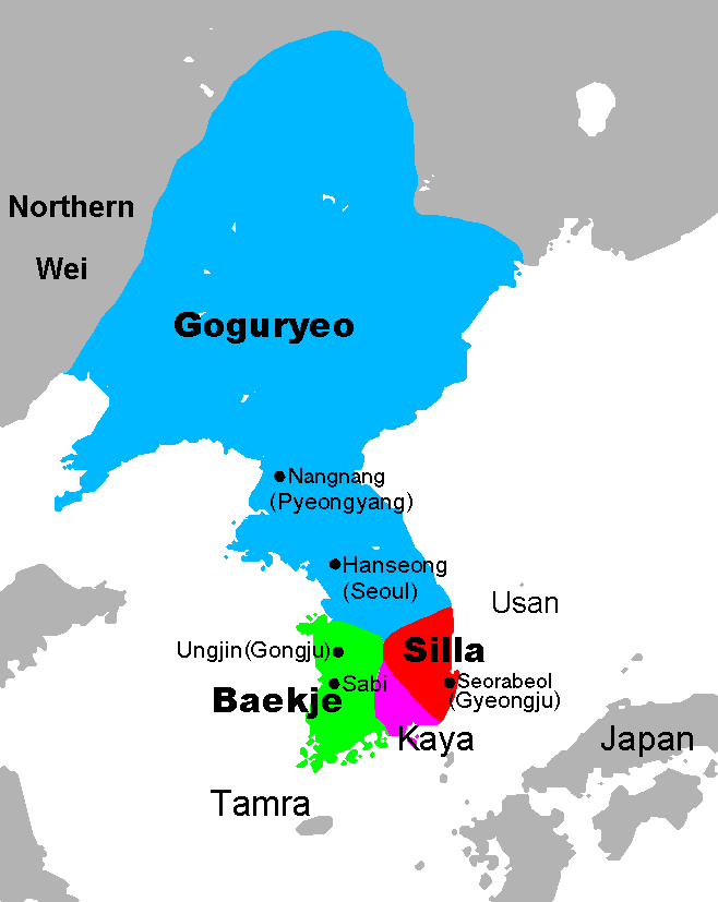
Map of the Three Kingdoms of Korea, at the end of the 5th century, with the largest expansion of Goguryeo. Hanseong was initially the capital of Baekje. Note that the spellings of the countries and cities may differ significantly in different sources.

|
Ezt a képet el kellene készíteni vektorgrafika használatával SVG fájlként. A formátumnak számos előnye van; lásd a Commons:Media for cleanup lapot a további információkért. Ha a képnek már elérhető SVG-formátumú változata, töltsd fel. Az SVG feltöltése után cseréld le ezt a sablont a következőre: {{vector version available|új kép neve.svg}}.
|
Map data from [1] archivált másolat at the Wayback Machine, which is GFDL, modified and map creation by Chris 73.
- Extra borders removed by Kooo.
- See also: Image:Three Kingdoms of Korea blank.png for a blank map.
- The source file is an open office.org file
Used in:
| Licensing:
This image was created by Chris 73. The image is licensed under a dual license; please choose either of the two licenses below as desired. Attribution to Wikipedia or another project of the Wikimedia foundation is required for both licenses if the image is used outside of projects of the Wikimedia foundation. Attribution to me is not required.
Ez a fájl a Creative Commons Nevezd meg! – Így add tovább! 3.0 Unported licenc alapján használható fel. Így nevezd meg: Chris 73 / Wikimedia Commons
"I want to use the image. How do I do that?" You can use this image freely for any purpose, including commercial use, provided that you license it under one of the above licenses. My suggestion is to use the following text:
For privacy reasons please use only "Chris 73" as author. If necessary, please translate the text in your language. For electronic use please include the links in the text as shown, for printed use please print the text as shown. If you use the image I would appreciate it if you would let me know on my talk page, but this is not required as long as you follow one of the above licenses. |

Fájltörténet
Kattints egy időpontra, hogy a fájl akkori állapotát láthasd.
| Dátum/idő | Bélyegkép | Felbontás | Feltöltő | Megjegyzés | |
|---|---|---|---|---|---|
| aktuális | 2018. július 23., 11:48 | | 658 × 827 (30 KB) | Dddcg | Use Korean's term on Korean article. Correct terms are Gaya(Kaya, Imna) and Tamna |
| 2018. július 18., 21:04 |  | 658 × 827 (25 KB) | Satoshi Kondo | fixed a former mistake of me | |
| 2018. június 12., 11:57 |  | 658 × 827 (19 KB) | Satoshi Kondo | correction on baekje and silla | |
| 2013. január 4., 02:41 |  | 658 × 827 (30 KB) | Shibo77 | Corrected locations of Sabi, Ungjin, Northern Wei. Revised Romanisation for Pyeongyang. Contemporary names Nangnang and Seorabeul for modern Pyeongyang and Gyeongju. See Wikimedia Commons talk page. | |
| 2010. november 14., 17:36 |  | 658 × 827 (17 KB) | Valentim | Reverted to version as of 06:23, 13 November 2010. Maybee I'm wrong, see User talk:Valentim#Look at the ja:利用者‐会話:トムル#失礼します.. | |
| 2010. november 13., 15:54 |  | 658 × 827 (17 KB) | Valentim | Reverted to version as of 13:42, 10 November 2010. That I wanted to tell you: Tamna is all right, Tamra not. But as you admid that Tamra is wrong: Why don't you stop to upload your wrong version? USE THE DISKUSSION! | |
| 2010. november 13., 08:23 |  | 658 × 827 (17 KB) | Garam | Reverted to version as of 09:12, 10 November 2010 // Look at the Tamna(korean) | |
| 2010. november 10., 15:42 |  | 658 × 827 (17 KB) | Valentim | Reverted to version as of 09:36, 26 September 2010. See w:en:Jeju-do. Do you know why we got discussion pages for? Maybee for cases like this one? | |
| 2010. november 10., 11:12 |  | 658 × 827 (17 KB) | Garam | Reverted to version as of 12:14, 2 September 2010 // Oh, my got.. Hey, Do you know what kind korean histroy? | |
| 2010. szeptember 26., 11:36 |  | 658 × 827 (17 KB) | Valentim | Reverted to version as of 14:56, 2 August 2009. "Tamra" was never a reference name to Jeju-do. |
Fájlhasználat
Ezt a fájlt nem használja egyetlen lap sem.
Globális fájlhasználat
A következő wikik használják ezt a fájlt:
- Használata itt: af.wikipedia.org
- Használata itt: als.wikipedia.org
- Használata itt: ar.wikipedia.org
- Használata itt: ast.wikipedia.org
- Használata itt: bg.wikipedia.org
- Használata itt: ckb.wikipedia.org
- Használata itt: csb.wikipedia.org
- Használata itt: cs.wikipedia.org
- Használata itt: da.wikipedia.org
- Használata itt: de.wikipedia.org
- Használata itt: en.wikipedia.org
- Használata itt: en.wikibooks.org
- Használata itt: en.wikivoyage.org
- Használata itt: eo.wikipedia.org
- Használata itt: fi.wikipedia.org
- Használata itt: fr.wikipedia.org
- Használata itt: gl.wikipedia.org
- Használata itt: he.wikipedia.org
- Használata itt: hr.wikipedia.org
- Használata itt: id.wikipedia.org
- Használata itt: io.wikipedia.org
- Használata itt: it.wikipedia.org
A fájl globális használatának megtekintése