
Fájl:US Secession map 1863 (BlankMap derived).png

Az előnézet mérete: 800 × 488 képpont További felbontások: 320 × 195 képpont | 640 × 390 képpont | 841 × 513 képpont.
Eredeti fájl (841 × 513 képpont, fájlméret: 24 KB, MIME-típus: image/png)
|
Ez a fájl a Wikimedia Commonsból származik. Az alább látható leírás az ottani dokumentációjának másolata. A Commons projekt szabad licencű kép- és multimédiatár. Segíts te is az építésében! |
.png)

|
Ezt a képet el kellene készíteni vektorgrafika használatával SVG fájlként. A formátumnak számos előnye van; lásd a Commons:Media for cleanup lapot a további információkért. Ha a képnek már elérhető SVG-formátumú változata, töltsd fel. Az SVG feltöltése után cseréld le ezt a sablont a következőre: {{vector version available|új kép neve.svg}}.
|
Összefoglaló
| Leírás |
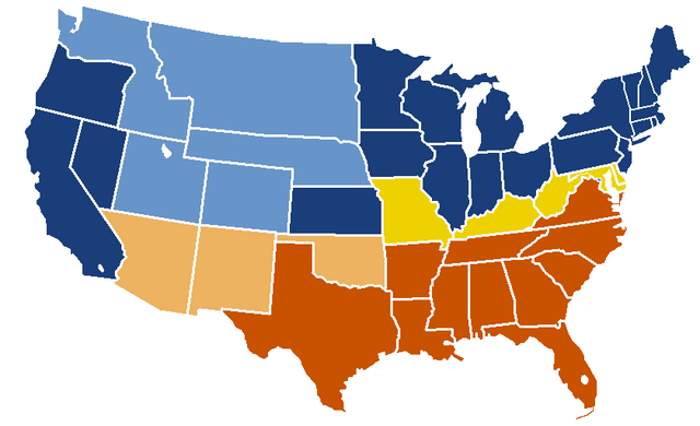
English: United States map of 1863, show affiliation of states and territories regarding the Secession War (Civil War.) Legend:
Union states Union territories not permitting slavery Border Union states, permitting slavery Confederate states Union territories permitting slavery (claimed by Confederacy) |
| Dátum | eredeti feltöltésének dátuma: 19:04, 24 February 2007 |
| Forrás |
|
| Szerző | w:en:Porsche997SBS (vitalap | szerkesztései) |
Licenc
This map was obtained from an edition of the National Atlas of the United States. Like almost all works of the U.S. federal government, works from the National Atlas are in the public domain in the United States.
Online access: NationalAtlas.gov | 1970 print edition: Library of Congress, Perry-Castañeda Library
|
Eredeti feltöltési napló
| date/time | username | resolution | size | edit summary |
|---|---|---|---|---|
| 19:04, 24 February 2007 | w:en:User:Porsche997SBS | 841×513 | 24 KB | trimming blankness |
| 18:59, 24 February 2007 | w:en:User:Porsche997SBS | 841×580 | 25 KB | don't need that |
| 18:55, 24 February 2007 | w:en:User:Porsche997SBS | 841×580 | 29 KB | format based on [http://en.wikipedia.org/wiki/Image:BlankMap-USA-states.PNG this image]; information from [http://en.wikipedia.org/wiki/Image:US_Secession_map_1865.svg this image]; see description pages there |
Image description page history
| link | date/time | username | edit summary |
|---|---|---|---|
| http://en.wikipedia.org/w/index.php?title=Image:US_Secession_map_1865_(BlankMap_derived).PNG&redirect=no&oldid=110635613 | 07:40, 10 September 2007 | w:en:User:Dmcdevit | |
| http://en.wikipedia.org/w/index.php?title=Image:US_Secession_map_1865_(BlankMap_derived).PNG&redirect=no&oldid=110635613 | 19:02, 24 February 2007 | w:en:User:Porsche997SBS | |
| http://en.wikipedia.org/w/index.php?title=Image:US_Secession_map_1865_(BlankMap_derived).PNG&redirect=no&oldid=110634272 | 18:55, 24 February 2007 | w:en:User:Porsche997SBS | (format based on [http://en.wikipedia.org/wiki/Image:BlankMap-USA-states.PNG this image]; information from [http://en.wikipedia.org/wiki/Image:US_Secession_map_1865.svg this image]; see description pages there) |
.PNG&redirect=no&oldid=110635613)
.PNG&redirect=no&oldid=110634272)
Fájltörténet
Kattints egy időpontra, hogy a fájl akkori állapotát láthasd.
| Dátum/idő | Bélyegkép | Felbontás | Feltöltő | Megjegyzés | |
|---|---|---|---|---|---|
| aktuális | 2010. január 14., 23:08 | | 841 × 513 (24 KB) | Porsche997SBS | Reverted to version as of 09:03, 14 January 2010--so frustrating |
| 2010. január 14., 23:07 |  | 841 × 513 (12 KB) | Porsche997SBS | let's try again | |
| 2010. január 14., 11:03 |  | 841 × 513 (24 KB) | Porsche997SBS | upload error? | |
| 2010. január 14., 10:52 |  | 841 × 513 (24 KB) | Porsche997SBS | fixing Nebraska, Dakota, and Washington territories and the border between Nevada and Utah | |
| 2010. január 14., 09:56 |  | 841 × 513 (24 KB) | Porsche997SBS | gray to blue | |
| 2007. december 29., 10:32 |  | 841 × 513 (24 KB) | Porsche997SBS | updating red to grey | |
| 2007. szeptember 13., 18:45 |  | 841 × 513 (24 KB) | BetacommandBot | Transwiki approved by: w:en:User:Dmcdevit This image was copied from wikipedia:en. The original description was: format based on [http://en.wikipedia.org/wiki/Image:BlankMap-USA-states.PNG this image]; information from [http://en.wikipedia.org/wiki/ |
Fájlhasználat
Az alábbi lap használja ezt a fájlt:
Globális fájlhasználat
A következő wikik használják ezt a fájlt:
- Használata itt: anp.wikipedia.org
- Használata itt: ar.wikipedia.org
- Használata itt: azb.wikipedia.org
- Használata itt: cs.wikipedia.org
- Használata itt: eml.wikipedia.org
- Használata itt: en.wikipedia.org
- Használata itt: eo.wikipedia.org
- Használata itt: he.wikipedia.org
- Használata itt: hi.wikipedia.org
- Használata itt: hy.wikipedia.org
- Használata itt: ja.wikipedia.org
- Használata itt: kk.wikipedia.org
- Használata itt: kn.wikipedia.org
- Használata itt: ko.wikipedia.org
- Használata itt: la.wikipedia.org
- Használata itt: lt.wikipedia.org
- Használata itt: ml.wikipedia.org
- Használata itt: pt.wikipedia.org
- Használata itt: ru.wikipedia.org
- Használata itt: si.wikipedia.org
- Használata itt: sk.wikipedia.org
- Használata itt: th.wikipedia.org
- Használata itt: vi.wikipedia.org
.png)