
Fájl:Miletus Bay silting evolution map-en.svg

Ennek a(z) SVG fájlnak ezen PNG formátumú előnézete: 800 × 581 képpont. További felbontások: 320 × 232 képpont | 640 × 465 képpont | 1 024 × 744 képpont | 1 280 × 930 képpont | 2 560 × 1 860 képpont | 1 857 × 1 349 képpont.
Eredeti fájl (SVG fájl, névlegesen 1 857 × 1 349 képpont, fájlméret: 1,54 MB)
|
Ez a fájl a Wikimedia Commonsból származik. Az alább látható leírás az ottani dokumentációjának másolata. A Commons projekt szabad licencű kép- és multimédiatár. Segíts te is az építésében! |
Összefoglaló
| Fényképező elhelyezkedése | | További képek erről a helyről: OpenStreetMap |
|---|
| Leírás |
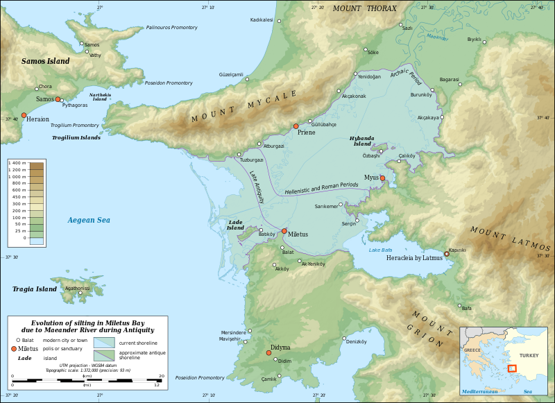
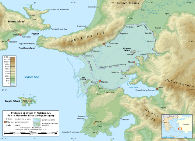
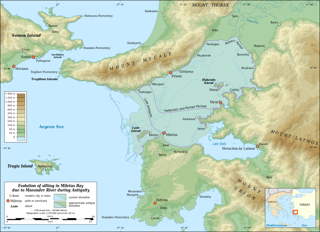
English: Map in English showing the silting evolution of Miletus Bay due to the alluvium brought by the Maeander River during Antiquity. Are also displayed some of the modern cities and towns of the area, the current course of the Maeander River and the current shoreline.
Notes:
Français : Carte en anglais de l'évolution de l'ensablement de la baie de Milet dû aux alluvions déposés par le Méandre. Sont aussi montrés le parcours actuel du Méandre, le littoral actuel et diverses agglomérations modernes. Notes :
UTM projection – WGS84 datum |
||
| Dátum | |||
| Forrás |
A feltöltő saját munkája
|
||
| Szerző | Eric Gaba (Sting - fr:Sting) | ||
| Engedély (Fájl újrafelhasználása) |
|
||
| Más változatok |
|


|
Ez az SVG-fájl beágyazott szöveget tartalmaz, amit könnyen magyarra lehetne fordítani a bármilyen megfelelő SVG- vagy szövegszerkesztővel, vagy az SVG-fordító eszközzel. További információkért lásd: SVG-fájlok fordítása. |
Licenc
Eric Gaba, Wikimedia Commons user Sting, e mű szerzője a művét az alábbi licencek alatt teszi közzé:

|
Ez a fájl szabadon másolható, terjeszthető és/vagy módosítható a GNU Szabad Dokumentációs Licenc feltételei alapján, az 1.2 vagy későbbi, a Free Software Foundation által publikált Nem Változtatható szakaszok, Címlapszövegek és Hátlapszövegek nélküli változat szerint. E licenc egy példánya a GNU Szabad Dokumentációs Licenc című fejezetben olvasható. |
Ez a fájl a Creative Commons Nevezd meg! – Így add tovább! 3.0 Unported licenc alapján használható fel.
Így nevezd meg: Eric Gaba, Wikimedia Commons user Sting
- A következőket teheted a művel:
- megoszthatod – szabadon másolhatod, terjesztheted, bemutathatod és előadhatod a művet
- feldolgozhatod – származékos műveket hozhatsz létre
- Az alábbi feltételekkel:
- Nevezd meg! – A szerzőt megfelelően fel kell tüntetned, hivatkozást kell létrehoznod a licencre és jelezned kell, ha a művön változtatást hajtottál végre. Ezt bármilyen észszerű módon megteheted, kivéve oly módon, ami azt sugallná hogy a jogosult támogat téged vagy a felhasználásod körülményeit.
- Így add tovább! – Ha megváltoztatod, átalakítod, feldolgozod ezt a művet, a közreműködésedet csak az eredetivel megegyező vagy hasonló licenc alatt terjesztheted.
A mű a fenti licencek bármelyike szerint felhasználható.
Fájltörténet
Kattints egy időpontra, hogy a fájl akkori állapotát láthasd.
| Dátum/idő | Bélyegkép | Felbontás | Feltöltő | Megjegyzés | |
|---|---|---|---|---|---|
| aktuális | 2010. július 16., 23:00 | | 1 857 × 1 349 (1,54 MB) | Sting | Test: embedded sRGB profile |
| 2009. július 2., 14:22 |  | 1 857 × 1 349 (1,59 MB) | Sting | == Summary == {{Location|37|35|00|N|27|16|00|E|scale:500000}} <br/> {{Information| |Description={{en|Map in English showing the silting evolution of Miletus Bay due to the alluvium brought by the [[:en:Büyük Menderes River|Maeander Rive |
Fájlhasználat
Az alábbi lapok használják ezt a fájlt:
Globális fájlhasználat
A következő wikik használják ezt a fájlt:
- Használata itt: ar.wikipedia.org
- Használata itt: azb.wikipedia.org
- Használata itt: az.wikipedia.org
- Használata itt: bg.wikipedia.org
- Használata itt: ca.wikipedia.org
- Használata itt: ceb.wikipedia.org
- Használata itt: cs.wikipedia.org
- Használata itt: de.wikipedia.org
- Használata itt: de.wikivoyage.org
- Használata itt: el.wikipedia.org
- Használata itt: en.wikipedia.org
- Miletus
- Priene
- Battle of Mycale
- Didyma
- Büyük Menderes River
- Mycale
- Lake Bafa
- Battle of Lade (201 BCE)
- Myus
- Beşparmak Mountains
- Dilek Peninsula-Büyük Menderes Delta National Park
- Wikipedia:Featured picture candidates/October-2016
- Wikipedia:Featured picture candidates/Miletus Bay Silting Map
- User:Abyssal/bla
- Lydian–Milesian War
- Használata itt: es.wikipedia.org
- Használata itt: fa.wikipedia.org
- Használata itt: fi.wikipedia.org
- Használata itt: fr.wikipedia.org
- Használata itt: he.wikipedia.org
- Használata itt: hr.wikipedia.org
A fájl globális használatának megtekintése