
Fájl:Mid-atlantic ridge map.png
Nem érhető el nagyobb felbontású változat.
Mid-atlantic_ridge_map.png (200 × 415 képpont, fájlméret: 21 KB, MIME-típus: image/png)
|
Ez a fájl a Wikimedia Commonsból származik. Az alább látható leírás az ottani dokumentációjának másolata. A Commons projekt szabad licencű kép- és multimédiatár. Segíts te is az építésében! |
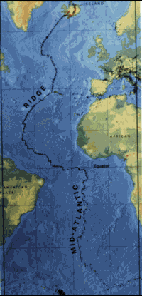
| Leírás | small image showing the location of the Mid-Atlantic ridge |
| Forrás | [1] |
| Szerző | originally uploaded on the English wikipedia: 14:51, 21 October 2003 . . JamesDay (Talk / contribs) . . 200×415 (21,177 bytes) (mid-Atlantic ridge map) |
| Engedély (Fájl újrafelhasználása) |
Copyright: public domain. US Geological Survey image. Copyright statement: [2] "Information presented on this website is considered public information and may be distributed or copied. Use of appropriate byline/photo/image credit is requested." |
This image is in the public domain in the United States because it only contains materials that originally came from the United States Geological Survey, an agency of the United States Department of the Interior. For more information, see the official USGS copyright policy.
|
Fájltörténet
Kattints egy időpontra, hogy a fájl akkori állapotát láthasd.
| Dátum/idő | Bélyegkép | Felbontás | Feltöltő | Megjegyzés | |
|---|---|---|---|---|---|
| aktuális | 2007. február 1., 13:02 | | 200 × 415 (21 KB) | Woudloper | {{Information |Description=small image showing the location of the Mid-Atlantic ridge |Source=[http://pubs.usgs.gov/publications/text/ridge.html] |Date= |Author=originally uploaded on the English wikipedia: 14:51, 21 October 2003 . . JamesDay (Talk | cont |
Fájlhasználat
Az alábbi lap használja ezt a fájlt:
Globális fájlhasználat
A következő wikik használják ezt a fájlt:
- Használata itt: ar.wikipedia.org
- Használata itt: ast.wikipedia.org
- Használata itt: bg.wikipedia.org
- Használata itt: ce.wikipedia.org
- Használata itt: da.wikipedia.org
- Használata itt: en.wikipedia.org
- Használata itt: en.wikibooks.org
- Használata itt: es.wikipedia.org
- Használata itt: fa.wikipedia.org
- Használata itt: fi.wikipedia.org
- Használata itt: gl.wikipedia.org
- Használata itt: is.wikipedia.org
- Használata itt: ka.wikipedia.org
- Használata itt: ko.wikipedia.org
- Használata itt: lt.wikipedia.org
- Használata itt: mk.wikipedia.org
- Használata itt: ml.wikipedia.org
- Használata itt: ms.wikipedia.org
- Használata itt: nl.wikipedia.org
- Használata itt: no.wikipedia.org
- Használata itt: pt.wikipedia.org
- Használata itt: ro.wikipedia.org
- Használata itt: ru.wikinews.org
- Használata itt: simple.wikipedia.org
- Használata itt: sl.wikipedia.org
- Használata itt: sr.wikipedia.org
- Használata itt: sw.wikipedia.org
- Használata itt: tr.wikipedia.org
- Használata itt: uk.wikipedia.org
- Használata itt: vi.wikipedia.org
- Használata itt: zh-yue.wikipedia.org
- Használata itt: zh.wikipedia.org