
Fájl:Hayward fault california.tif

Ennek a(z) TIF fájlnak ezen JPG formátumú előnézete: 536 × 599 képpont. További felbontások: 215 × 240 képpont | 429 × 480 képpont | 687 × 768 képpont | 916 × 1 024 képpont | 2 135 × 2 386 képpont.
Eredeti fájl (2 135 × 2 386 képpont, fájlméret: 10,56 MB, MIME-típus: image/tiff)
|
Ez a fájl a Wikimedia Commonsból származik. Az alább látható leírás az ottani dokumentációjának másolata. A Commons projekt szabad licencű kép- és multimédiatár. Segíts te is az építésében! |
Összefoglaló
| Leírás |
English: This image of California's Hayward fault is an interferogram created using a pair of images taken by Synthetic Aperture Radar (SAR) combined to measure changes in the surface that may have occurred between the time the two images were taken.
The images were collected by the European Space Agency's Remote Sensing satellites ERS-1 and ERS-2 in June 1992 and September 1997 over the central San Francisco Bay in California. The radar image data are shown as a gray-scale image, with the interferometric measurements that show the changes rendered in color. Only the urbanized area could be mapped with these data. The color changes from orange tones to blue tones across the Hayward fault (marked by a thin red line) show about 2-3 centimeters (0.8-1.1 inches) of gradual displacement or movement of the southwest side of the fault. The block west of the fault moved horizontally toward the northwest during the 63 months between the acquisition of the two SAR images. This fault movement is called aseismic creep because the fault moved slowly without generating an earthquake. |
| Dátum | |
| Forrás | http://visibleearth.nasa.gov/view_rec.php?id=730 |
| Szerző | NASA JPL, University of California at Berkeley, Lawrence Berkeley National Laboratory |
Licenc
| Ezt a fájlt a NASA készítette, ezért az Egyesült Államokban közkincsnek számít. A NASA szerzői jogi irányelve alapján „a NASA anyagai nem állnak szerzői jogi védelem alatt, kivéve, ha az külön jelezve van". (Lásd még: Sablon:PD-USGov, a NASA szerzői jogi- és a JPL képhasználati irányelve.) | ||
 |
Figyelmeztetések:
|
Fájltörténet
Kattints egy időpontra, hogy a fájl akkori állapotát láthasd.
| Dátum/idő | Bélyegkép | Felbontás | Feltöltő | Megjegyzés | |
|---|---|---|---|---|---|
| aktuális | 2011. március 4., 11:26 | 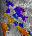 | 2 135 × 2 386 (10,56 MB) | Kkaattaa8 | {{Information |Description ={{en|1=This image of California's Hayward fault is an interferogram created using a pair of images taken by Synthetic Aperture Radar (SAR) combined to measure changes in the surface that may have occurred between the time th |
Fájlhasználat
Az alábbi lap használja ezt a fájlt:
Globális fájlhasználat
A következő wikik használják ezt a fájlt:
- Használata itt: fr.wikipedia.org