
Fájl:AlbaniaTraditionalCommunitiesByLanguageAndReligion.png

Az előnézet mérete: 461 × 599 képpont További felbontások: 184 × 240 képpont | 540 × 702 képpont.
Eredeti fájl (540 × 702 képpont, fájlméret: 26 KB, MIME-típus: image/png)
|
Ez a fájl a Wikimedia Commonsból származik. Az alább látható leírás az ottani dokumentációjának másolata. A Commons projekt szabad licencű kép- és multimédiatár. Segíts te is az építésében! |
Összefoglaló
| Leírás |
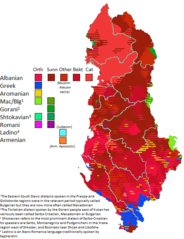
English: This map, using a wide variety of sources (available in a chart for where they apply), charts the traditional locations of notable linguistic and religious communities in Albania, around the early 20th century. Note that hatched areas imply the presence of multiple groups, but they do not imply parity-- in fact usually there is not parity. Thus this map underrepresents the demographic weight of local majorities -- such as Sunnis in Elbasan who are in a hatched area with Orthodox who they vastly outnumber. Thus in different areas, Sunni Albanians, Bektashi Albanians, Orthodox Albanians, Catholic Albanians, and Orthodox Greeks are likely underrepresented, while smaller groups (Vlachs, Sephardim, Roma) may be overrepresented where they occur. The citation chart for this map is can be found here (currently under construction still). If you do choose to edit this file, please edit this page as well so I know which sources you used. You may also use this page to request edits to the file, by presenting a source and saying where it pertains to, below the chart. |
| Dátum | |
| Forrás | A feltöltő saját munkája |
| Szerző | Calthinus |
Licenc
Én, e mű szerzője a művemet az alábbi licenc alatt teszem közzé:
Ez a fájl a Creative Commons Nevezd meg! – Így add tovább! 4.0 Nemzetközi licenc alapján használható fel.
- A következőket teheted a művel:
- megoszthatod – szabadon másolhatod, terjesztheted, bemutathatod és előadhatod a művet
- feldolgozhatod – származékos műveket hozhatsz létre
- Az alábbi feltételekkel:
- Nevezd meg! – A szerzőt megfelelően fel kell tüntetned, hivatkozást kell létrehoznod a licencre és jelezned kell, ha a művön változtatást hajtottál végre. Ezt bármilyen észszerű módon megteheted, kivéve oly módon, ami azt sugallná hogy a jogosult támogat téged vagy a felhasználásod körülményeit.
- Így add tovább! – Ha megváltoztatod, átalakítod, feldolgozod ezt a művet, a közreműködésedet csak az eredetivel megegyező vagy hasonló licenc alatt terjesztheted.
Fájltörténet
Kattints egy időpontra, hogy a fájl akkori állapotát láthasd.
| Dátum/idő | Bélyegkép | Felbontás | Feltöltő | Megjegyzés | |
|---|---|---|---|---|---|
| aktuális | 2021. november 5., 07:37 | | 540 × 702 (26 KB) | User-duck | Cropped narrower using CropTool with lossless mode. |
| 2020. január 19., 00:16 |  | 655 × 709 (70 KB) | Calthinus | let's try this again.... | |
| 2020. január 17., 23:33 |  | 655 × 709 (71 KB) | Calthinus | Labova to mixed -- source reports village as Greek/Albanian mixed in early to mid 20th century before settlement of Vlachs (Hammond, Hemming; Kahl on Vlach settlement). Extend Greek area West of Himare munic to Grammata bay per comments by Kh/Alexikoua, that's fair enough. Per Resnjari and Khirurg, change Albanian enclaves in Vurg to dots (I can't find the cadastre map but I suppose this will do). Remove Greek patch in Moscopole per Resnjari's complaint. | |
| 2018. január 11., 05:51 |  | 655 × 709 (67 KB) | Calthinus | fixes in Himara, Zagori, Permet. Will deal with Vurg and Moscopole soon. | |
| 2017. december 30., 18:32 |  | 655 × 709 (67 KB) | Calthinus | I appreciate the attempt but this is not fitting the language-religion paradigm. I will fix permet once I get a moment. Thanks. | |
| 2017. december 30., 00:44 |  | 655 × 709 (72 KB) | SilentResident | Updated map with the missing sources from Philippe Rekacewicz and George Soteriadis to eliminate potential POV issues. Now the updated map contains all scholarship about the Greek population inhabiting these areas. The missing sources that have been a... | |
| 2017. december 23., 02:04 |  | 655 × 709 (67 KB) | Calthinus | oops uploaded wrong one | |
| 2017. december 23., 02:00 |  | 655 × 709 (67 KB) | Calthinus | Apparently there are no Slavic Muslims in Tarnovo, as per Ylli + Steinke. Also some fixes elsewhere | |
| 2017. december 20., 07:50 |  | 655 × 709 (67 KB) | Calthinus | quick fix | |
| 2017. december 20., 07:19 |  | 655 × 709 (67 KB) | Calthinus | fixes for a couple towns |
Fájlhasználat
Az alábbi lap használja ezt a fájlt:
Globális fájlhasználat
A következő wikik használják ezt a fájlt:
- Használata itt: ar.wikipedia.org
- Használata itt: az.wikipedia.org
- Használata itt: bn.wikipedia.org
- Használata itt: cs.wikipedia.org
- Használata itt: de.wikipedia.org
- Használata itt: el.wikipedia.org
- Használata itt: en.wikipedia.org
- Használata itt: fy.wikipedia.org
- Használata itt: it.wikipedia.org
- Használata itt: ko.wikipedia.org
- Használata itt: lv.wikipedia.org
- Használata itt: mk.wikipedia.org
- Használata itt: ro.wikipedia.org
- Használata itt: ru.wikipedia.org
- Használata itt: te.wikipedia.org
- Használata itt: tr.wikipedia.org
- Használata itt: uk.wikipedia.org