
Fájl:Tokyo L7 lrg.jpg

Az előnézet mérete: 600 × 600 képpont További felbontások: 240 × 240 képpont | 480 × 480 képpont | 1 000 × 1 000 képpont.
Eredeti fájl (1 000 × 1 000 képpont, fájlméret: 511 KB, MIME-típus: image/jpeg)
|
Ez a fájl a Wikimedia Commonsból származik. Az alább látható leírás az ottani dokumentációjának másolata. A Commons projekt szabad licencű kép- és multimédiatár. Segíts te is az építésében! |
Összefoglaló
| Leírás |
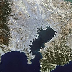
English: This false-color Landsat 7 image shows (a large part of) the greater Tokyo metropolitan area, situated on the eastern shore of the Japanese island of Honshu. The large Tokyo Bay dominates the center of this scene, and if you look closely you can see boats and their wakes on the water. The greater Tokyo area fans out in a crescent shape around the western, northern, and eastern shores of Tokyo Bay. Greater Tokyo is bordered to the west by rugged mountains and to the east by the vast expanse of the Pacific Ocean.
The greater metropolis area is comprised of Tokyo prefecture, situated on the northwestern shore of Tokyo Bay, and the three neighboring prefectures of Kanagawa to the south, Saitama to the north, and Chiba to the east and southeast across Tokyo Bay. Over the last 400 years, Japan’s National Capital Region has evolved into a large, self-governing unit consisting of 26 cities, 5 towns, and 8 villages. The region is home to some 38 million people in 2018 (more than a quarter of Japan’s whole population) in a metropolitan area spanning 14,034 square km. 日本語: 東京湾の衛星画像(2002年)人工衛星「NASA Earth Observatory」による。 |
| Dátum | |
| Forrás | Earth Observatory |
| Szerző | Image courtesy Ron Beck, USGS Eros Data Center Satellite Systems Branch |
Licenc
| Ezt a fájlt a NASA készítette, ezért az Egyesült Államokban közkincsnek számít. A NASA szerzői jogi irányelve alapján „a NASA anyagai nem állnak szerzői jogi védelem alatt, kivéve, ha az külön jelezve van". (Lásd még: Sablon:PD-USGov, a NASA szerzői jogi- és a JPL képhasználati irányelve.) | ||
 |
Figyelmeztetések:
|
Fájltörténet
Kattints egy időpontra, hogy a fájl akkori állapotát láthasd.
| Dátum/idő | Bélyegkép | Felbontás | Feltöltő | Megjegyzés | |
|---|---|---|---|---|---|
| aktuális | 2008. november 18., 16:25 | | 1 000 × 1 000 (511 KB) | Jyusin | {{Information |Description={{en|1=Tokyo}} {{ja|1=東京}} |Source=[http://earthobservatory.nasa.gov/IOTD/view.php?id=2854 Earth Observatory] |Author=NASA |Date= |Permission= |other_versions= }} <!--{{ImageUpload|full}}--> |
Fájlhasználat
Az alábbi lap használja ezt a fájlt:
Globális fájlhasználat
A következő wikik használják ezt a fájlt:
- Használata itt: az.wikipedia.org
- Használata itt: de.wikipedia.org
- Használata itt: es.wikipedia.org
- Használata itt: fr.wikipedia.org
- Használata itt: it.wikipedia.org
- Használata itt: ja.wikipedia.org
- Használata itt: pt.wikipedia.org
- Használata itt: simple.wikipedia.org
- Használata itt: tr.wikipedia.org
- Használata itt: vi.wikipedia.org
- Használata itt: zh.wikipedia.org