
Fájl:Oberstenfeld - Burg Lichtenberg - Ansicht von WSW (2).jpg

Az előnézet mérete: 800 × 541 képpont További felbontások: 320 × 216 képpont | 640 × 433 képpont | 1 024 × 692 képpont | 1 280 × 866 képpont | 2 560 × 1 731 képpont | 7 654 × 5 176 képpont.
Eredeti fájl (7 654 × 5 176 képpont, fájlméret: 21,66 MB, MIME-típus: image/jpeg)
|
Ez a fájl a Wikimedia Commonsból származik. Az alább látható leírás az ottani dokumentációjának másolata. A Commons projekt szabad licencű kép- és multimédiatár. Segíts te is az építésében! |
.jpg)
Összefoglaló
| Leírás |
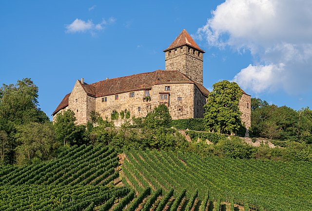
Deutsch: Die Burg Lichtenberg bei Oberstenfeld (Landkreis Ludwigsburg) ist eine der besterhaltenen Burgen aus der Stauferzeit. Ansicht von West-Südwesten aus den Weinbergen im Lembachtal.
English: Lichtenberg Castle near Oberstenfeld (Ludwigsburg district, Germany) is one of the best preserved castles from the Staufer period. View from the vineyards from west-southwest.
Español: El castillo de Lichtenberg, cerca de Oberstenfeld (distrito de Ludwigsburg, Alemania) es uno de los castillos mejor conservados del período Staufen. Vista desde los viñedos del lado oeste-suroeste.
Македонски: Замокот Лихтенберг ие неговото лозје кај Оберстенфелд во Баден-Виртемберг, Германија.
Эрзянь: Лихтенберг замкась Оберстенфельд (Людвигсбург буе, Германия) — те Штауфер шкань сех ванстозь замкась.
Polski: Widok z winnic od strony południowo-zachodniej na zamek Lichtenberg koło Oberstenfeld w powiecie Ludwigsburg, w Niemczech, jeden z najlepiej zachowanych zamków z okresu panowania Hohenstaufów.
Português: Castelo de Lichtenberg, perto de Oberstenfeld, distrito de Ludwigsburg, Alemanha. É um dos castelos mais bem preservados do período Staufen. Vista dos vinhedos do lado sudoeste
Sardu: Su casteddu de Lichtenberg, a curtzu de Oberstenfeld (distretu de Ludwigsburg, Germània) est unu de sos casteddos de su perìodu Staufer cunservados mègius. Vista dae sas bìngias dae ovest-sudovest. |
| Dátum | Készült: 2019. szeptember 2., 18:20:48 |
| Forrás | A feltöltő saját munkája |
| Szerző | Roman Eisele |
| Fényképező elhelyezkedése | | További képek erről a helyről: OpenStreetMap |
|---|
.jpg¶ms=049.012590_N_0009.324501_E_globe:Earth_type:camera_heading:50.00&language=hu)
| Színtér | This image file uses the sRGB colour space. (Luckily today most systems and applications respect colour spaces and ICC profiles. But there may still be some exceptions: outdated or misconfigured software can display wrong colours. If you see strange colours or if the picture appears flat and low in contrast, you should try another application or device for viewing it.) |
| Personal photo ID | RQBB0649 (This is the reference number of this photograph in my archive. Please do not delete it, it is very useful for me! You may use this ID if you need to refer to one of my photographs.) |
| Így nevezd meg (a licenc megköveteli) | © Roman Eisele / Wikimedia Commons / CC BY-SA 4.0 |
| Using this picture | You can use this picture free of charge under the terms of the free license CC BY-SA 4.0. In particular, this means:
|
| Editing this picture | If you want to edit this picture for Commons, please upload your edited version using a new file name. My own version of this picture should be preserved and must be easily accessible. Please add the template {{Derived from}} or {{Extracted from}} to your version and use it to link to my original version of the picture. Thank you very much! |

|
Ezt a képet a Wiki Loves Monuments 2019 keretében töltötték fel.
|
Assessment
|
.jpg)
Ezt a képet a 2020. július 8-i nap képének választották, a következő képaláírással: Más nyelvek:
Deutsch: Die Burg Lichtenberg bei Oberstenfeld (Landkreis Ludwigsburg) ist eine der besterhaltenen Burgen aus der Stauferzeit. Ansicht aus den Weinbergen von Südwesten. English: Lichtenberg Castle near Oberstenfeld (Ludwigsburg district, Germany) is one of the best preserved castles from the Staufer period. View from the vineyards from south-west. Español: El castillo de Lichtenberg, cerca de Oberstenfeld (distrito de Ludwigsburg, Alemania) es uno de los castillos mejor conservados del período Staufen. Vista desde los viñedos del lado suroeste. Polski: Widok z winnic od strony południowo-zachodniej na zamek Lichtenberg koło Oberstenfeld w powiecie Ludwigsburg, w Niemczech, jeden z najlepiej zachowanych zamków z okresu panowania Hohenstaufów. Português: Castelo de Lichtenberg, perto de Oberstenfeld, distrito de Ludwigsburg, Alemanha. É um dos castelos mais bem preservados do período Staufen. Vista dos vinhedos do lado sudoeste Македонски: Замокот Лихтенберг ие неговото лозје кај Оберстенфелд во Баден-Виртемберг, Германија. |
Licenc
Én, e mű szerzője a művemet az alábbi licenc alatt teszem közzé:
Ez a fájl a Creative Commons Nevezd meg! – Így add tovább! 4.0 Nemzetközi licenc alapján használható fel.
- A következőket teheted a művel:
- megoszthatod – szabadon másolhatod, terjesztheted, bemutathatod és előadhatod a művet
- feldolgozhatod – származékos műveket hozhatsz létre
- Az alábbi feltételekkel:
- Nevezd meg! – A szerzőt megfelelően fel kell tüntetned, hivatkozást kell létrehoznod a licencre és jelezned kell, ha a művön változtatást hajtottál végre. Ezt bármilyen észszerű módon megteheted, kivéve oly módon, ami azt sugallná hogy a jogosult támogat téged vagy a felhasználásod körülményeit.
- Így add tovább! – Ha megváltoztatod, átalakítod, feldolgozod ezt a művet, a közreműködésedet csak az eredetivel megegyező vagy hasonló licenc alatt terjesztheted.
Fájltörténet
Kattints egy időpontra, hogy a fájl akkori állapotát láthasd.
| Dátum/idő | Bélyegkép | Felbontás | Feltöltő | Megjegyzés | |
|---|---|---|---|---|---|
| aktuális | 2019. szeptember 25., 16:16 | | 7 654 × 5 176 (21,66 MB) | Aristeas | User created page with UploadWizard |
Fájlhasználat
Az alábbi lapok használják ezt a fájlt:
Globális fájlhasználat
A következő wikik használják ezt a fájlt:
- Használata itt: als.wikipedia.org
- Használata itt: ba.wikipedia.org
- Használata itt: be-tarask.wikipedia.org
- Használata itt: ceb.wikipedia.org
- Használata itt: crh.wikipedia.org
- Használata itt: cv.wikipedia.org
- Használata itt: de.wikipedia.org
- Használata itt: de.wikivoyage.org
- Használata itt: en.wikipedia.org
- Használata itt: fr.wikipedia.org
- Használata itt: hy.wikipedia.org
- Használata itt: it.wikipedia.org
- Használata itt: it.wiktionary.org
- Használata itt: ka.wikipedia.org
- Használata itt: ko.wikipedia.org
- Használata itt: lbe.wikipedia.org
- Használata itt: lez.wikipedia.org
- Használata itt: mg.wikipedia.org
- Használata itt: mk.wikipedia.org
- Használata itt: os.wikipedia.org
- Használata itt: pt.wikipedia.org
- Használata itt: ru.wikipedia.org
- Használata itt: ru.wikinews.org
- Használata itt: sah.wikipedia.org
- Használata itt: sc.wikipedia.org
- Használata itt: sq.wikipedia.org
- Használata itt: tt.wikipedia.org
- Használata itt: vep.wikipedia.org
- Használata itt: www.wikidata.org
- Használata itt: zh.wikipedia.org
.jpg)