
Fájl:Eyjafjallajökull volcanic ash composite.png

Az előnézet mérete: 600 × 600 képpont További felbontások: 240 × 240 képpont | 480 × 480 képpont | 726 × 726 képpont.
Eredeti fájl (726 × 726 képpont, fájlméret: 95 KB, MIME-típus: image/png)
|
Ez a fájl a Wikimedia Commonsból származik. Az alább látható leírás az ottani dokumentációjának másolata. A Commons projekt szabad licencű kép- és multimédiatár. Segíts te is az építésében! |
| Leírás |
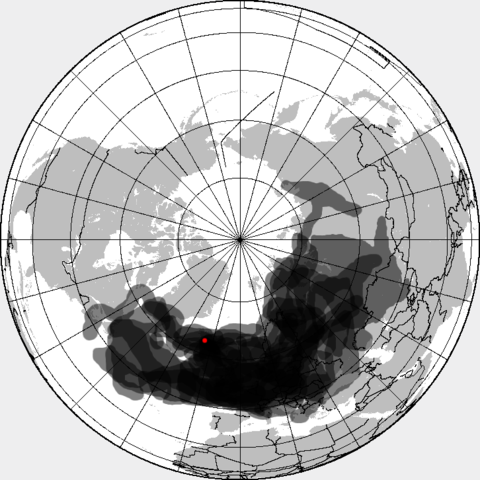
This is a composite map showing the position of the Icelandinc volcanic ash cloud that closed European air space in different days. Based on maps found at http://www.metoffice.gov.uk/aviation/vaac/vaacuk_vag.html Days included:
|
| Dátum | (UTC) |
| Forrás | |
| Szerző |
|
| Ez egy retusált kép, ami azt jelenti, hogy az eredetihez képest digitálisan módosították. Módosítások: made all day layers visible. Az eredeti itt található: Eyjafjallajökull volcanic ash multilayer.xcf. Módosította: Cogiati.
|
Én, e mű szerzője a művemet az alábbi licenc alatt teszem közzé:
Ez a fájl a Creative Commons Nevezd meg! – Így add tovább! 3.0 Unported licenc alapján használható fel.
- A következőket teheted a művel:
- megoszthatod – szabadon másolhatod, terjesztheted, bemutathatod és előadhatod a művet
- feldolgozhatod – származékos műveket hozhatsz létre
- Az alábbi feltételekkel:
- Nevezd meg! – A szerzőt megfelelően fel kell tüntetned, hivatkozást kell létrehoznod a licencre és jelezned kell, ha a művön változtatást hajtottál végre. Ezt bármilyen észszerű módon megteheted, kivéve oly módon, ami azt sugallná hogy a jogosult támogat téged vagy a felhasználásod körülményeit.
- Így add tovább! – Ha megváltoztatod, átalakítod, feldolgozod ezt a művet, a közreműködésedet csak az eredetivel megegyező vagy hasonló licenc alatt terjesztheted.
Eredeti feltöltési napló
This image is a derivative work of the following images:
- File:Eyjafjallajökull_volcanic_ash_multilayer.xcf licensed with Cc-by-sa-3.0
- 2010-04-25T01:29:03Z Cogiati 0x0 (853897 Bytes) added 22 april
- 2010-04-25T01:17:42Z Cogiati 0x0 (845598 Bytes) added 21 april
- 2010-04-25T00:01:51Z Cogiati 0x0 (832938 Bytes) added 19 april
- 2010-04-24T23:20:51Z Cogiati 0x0 (818621 Bytes) added 24 april
- 2010-04-23T21:13:03Z Cogiati 0x0 (814673 Bytes) added 15 april
- 2010-04-23T20:54:25Z Cogiati 0x0 (808456 Bytes) {{Information |Description=This map shows the Icelandic volcanic ash cloud that closed European air space. Every day is shown in a different layer. It's an XCf file editable with GIMP. Based on maps found at http://www.metoff
Uploaded with derivativeFX
Fájltörténet
Kattints egy időpontra, hogy a fájl akkori állapotát láthasd.
| Dátum/idő | Bélyegkép | Felbontás | Feltöltő | Megjegyzés | |
|---|---|---|---|---|---|
| aktuális | 2010. április 27., 16:53 | | 726 × 726 (95 KB) | Cogiati | added 17 april |
| 2010. április 26., 16:09 |  | 726 × 726 (93 KB) | Cogiati | added 18 april | |
| 2010. április 26., 09:32 |  | 726 × 726 (92 KB) | Cogiati | added 25 April | |
| 2010. április 25., 18:00 |  | 726 × 726 (91 KB) | Cogiati | added 16 april | |
| 2010. április 25., 03:56 |  | 726 × 726 (90 KB) | Cogiati | added 20 april | |
| 2010. április 25., 03:32 |  | 726 × 726 (88 KB) | Cogiati | {{Information |Description=This is a composite map showing the position of the Icelandinc volcanic ash cloud that closed European air space in different days. Based on maps found at http://www.metoffice.gov.uk/aviation/vaac/vaacuk_vag.html Days included: |
Fájlhasználat
Az alábbi lap használja ezt a fájlt:
Globális fájlhasználat
A következő wikik használják ezt a fájlt:
- Használata itt: ca.wikipedia.org
- Használata itt: da.wikipedia.org
- Használata itt: de.wikipedia.org
- Használata itt: en.wikipedia.org
- Használata itt: es.wikipedia.org
- Használata itt: eu.wikipedia.org
- Használata itt: fi.wikipedia.org
- Használata itt: it.wikipedia.org
- Használata itt: ja.wikipedia.org
- Használata itt: pnb.wikipedia.org
- Használata itt: pt.wikipedia.org
- Használata itt: ru.wikipedia.org
- Használata itt: th.wikipedia.org
- Használata itt: ur.wikipedia.org
- Használata itt: vi.wikipedia.org
- Használata itt: zh.wikipedia.org