
Fájl:Cook New Zealand South Cape.jpg
Eredeti fájl (800 × 618 képpont, fájlméret: 127 KB, MIME-típus: image/jpeg)
|
Ez a fájl a Wikimedia Commonsból származik. Az alább látható leírás az ottani dokumentációjának másolata. A Commons projekt szabad licencű kép- és multimédiatár. Segíts te is az építésében! |
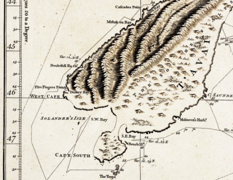
| Leírás | South-eastern part of the first complete map of New Zealand, drawn by James Cook. Cook believed that Stewart Island was connected to the South Island and thus named it South Cape. |
| Dátum | és 1770 között |
| Forrás | National Maritime Museum, London. Collections Online, Repro-ID: F0293 |
| Szerző |
"explored by Lieut. I. Cook, Commander of His Majesty's Bark Endeavour |
| Más változatok |
another version of Cook's map of all New Zealand: Image:Cook new zealand.jpg; |
|
Ez a mű közkincs abban az országban, ahol elkészítették, és minden olyan további államban, ahol a szerzői jogi védelmi idő a szerző élete plusz 100 év vagy kevesebb. | |
| Megállapították, hogy ez a fájl mentes mindenféle szerzői jogi korlátozástól, beleértve az összes kapcsolódó és hozzátartozó jogot. | |
Fájltörténet
Kattints egy időpontra, hogy a fájl akkori állapotát láthasd.
| Dátum/idő | Bélyegkép | Felbontás | Feltöltő | Megjegyzés | |
|---|---|---|---|---|---|
| aktuális | 2007. április 15., 16:59 | | 800 × 618 (127 KB) | Ibn Battuta | higher resolution of (another version of) Cook's map |
| 2007. április 1., 21:16 |  | 193 × 169 (16 KB) | Ibn Battuta | manually retraced contours of the connection between Stewart Island ("South Cape") and the South Island | |
| 2007. április 1., 21:10 |  | 193 × 169 (16 KB) | Ibn Battuta | shearing is nice, but the map got blurred as a result... back to the original version, only heightened contrast | |
| 2007. április 1., 11:28 |  | 193 × 171 (19 KB) | Ibn Battuta | okay, next try... - heightened contrast | |
| 2007. április 1., 11:26 |  | 193 × 171 (15 KB) | Ibn Battuta | increased contrast | |
| 2007. április 1., 11:21 |  | 193 × 171 (15 KB) | Ibn Battuta | {{Information |Description=South-eastern part of the first nearly complete map of New Zealand, drawn by James Cook. Cook believed that en:Stewart Island was connected to the South Island and thus named it South Cape. |Source= |Date=ca. 1770 | |
Fájlhasználat
Az alábbi lap használja ezt a fájlt: