
Fájl:1918 Flu pandemic-en.svg

Eredeti fájl (SVG fájl, névlegesen 560 × 375 képpont, fájlméret: 224 KB)
|
Ez a fájl a Wikimedia Commonsból származik. Az alább látható leírás az ottani dokumentációjának másolata. A Commons projekt szabad licencű kép- és multimédiatár. Segíts te is az építésében! |
Összefoglaló
| Leírás |
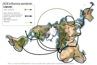
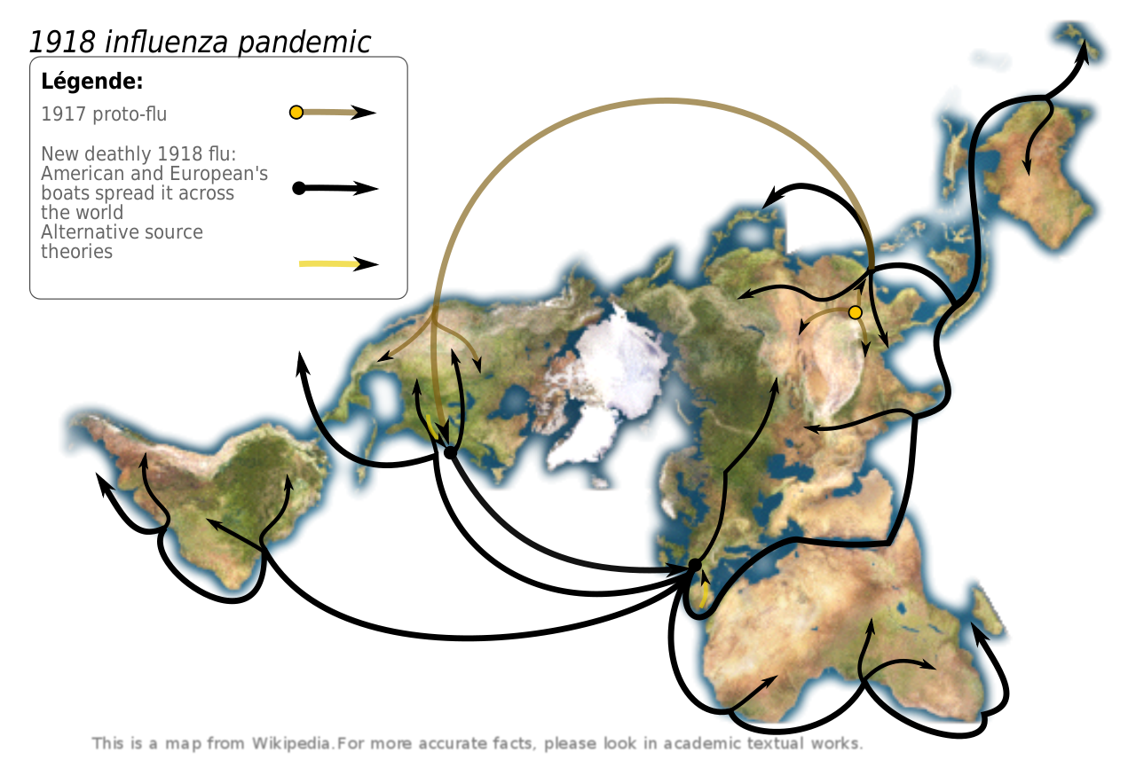
Map showing the 1918 Flu pandemic. Made according to Institut pasteur's data, graphism made by myself. Sources:
Pr. Hannoun being one of the world leading experts of the 1918 influenza, and the Institut Pasteur leading expert. In his paper, he support the Chinese origin, but also notice other theories.
|
||
| Dátum | (UTC) | ||
| Forrás | |||
| Szerző |
|
||
| SVG kód | Ezen SVG kép forráskódja érvénytelen. Ez vektorgrafikus kép Inkscape segítségével készült, or with something else.
|
Licenc
- A következőket teheted a művel:
- megoszthatod – szabadon másolhatod, terjesztheted, bemutathatod és előadhatod a művet
- feldolgozhatod – származékos műveket hozhatsz létre
- Az alábbi feltételekkel:
- Nevezd meg! – A szerzőt megfelelően fel kell tüntetned, hivatkozást kell létrehoznod a licencre és jelezned kell, ha a művön változtatást hajtottál végre. Ezt bármilyen észszerű módon megteheted, kivéve oly módon, ami azt sugallná hogy a jogosult támogat téged vagy a felhasználásod körülményeit.
- Így add tovább! – Ha megváltoztatod, átalakítod, feldolgozod ezt a művet, a közreműködésedet csak az eredetivel megegyező vagy hasonló licenc alatt terjesztheted.
Eredeti feltöltési napló
This image is a derivative work of the following images:
- Image:Dymaxion_map_unfolded-no-ocean.png licensed with PD-self
- 2005-08-28T12:36:31Z Rhythm 638x365 (137983 Bytes) this image may be subsitude by this other bigger one [[Image:Dymaxion continents.jpg|thumb]] ==Description== This is an unfolded [[dymaxion map]], unfolded to show the land-masses of the world as nearly continuous. This is a
Uploaded with derivativeFX
Fájltörténet
Kattints egy időpontra, hogy a fájl akkori állapotát láthasd.
| Dátum/idő | Bélyegkép | Felbontás | Feltöltő | Megjegyzés | |
|---|---|---|---|---|---|
| aktuális | 2009. május 1., 16:15 | | 560 × 375 (224 KB) | Yug | improvement : legend, colors, crop. |
| 2008. július 26., 03:00 |  | 638 × 365 (257 KB) | Yug | image size restored | |
| 2008. július 26., 02:56 |  | 638 × 365 (255 KB) | Yug | fix arrow bugs... putain j'en chie ! | |
| 2008. július 26., 02:42 |  | 638 × 365 (221 KB) | Yug | try again after sudo apt-get install python-lxml | |
| 2008. július 26., 02:34 |  | 638 × 365 (40 KB) | Yug | Try to avoid the embeded image bug | |
| 2008. július 26., 02:30 |  | 638 × 365 (40 KB) | Yug | {{Information |Description=Map showing the 1918 Flu pandemic. Data from personal research (source : Intitut pasteur), graphism made by myself. ;Derivate from Image:Dymaxion_map_unfolded-no-ocean.png This image may be substituted by this other bigger |
Fájlhasználat
Az alábbi lapok használják ezt a fájlt:
Globális fájlhasználat
A következő wikik használják ezt a fájlt:
- Használata itt: en.wikipedia.org
- Használata itt: en.wikiquote.org
- Használata itt: is.wikipedia.org
- Használata itt: ln.wikipedia.org
- Használata itt: mk.wikipedia.org