
Fájl:Teideform2.png

Az előnézet mérete: 504 × 600 képpont További felbontások: 202 × 240 képpont | 588 × 700 képpont.
Eredeti fájl (588 × 700 képpont, fájlméret: 58 KB, MIME-típus: image/png)
|
Ez a fájl a Wikimedia Commonsból származik. Az alább látható leírás az ottani dokumentációjának másolata. A Commons projekt szabad licencű kép- és multimédiatár. Segíts te is az építésében! |
Összefoglaló
| Leírás |
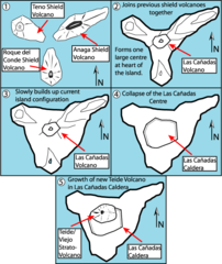
English: This is a very schematic diagram of the formation of the island of Tenerife and evolution of the current Teide volcano. In step one the island began as three separate shield volcanoes - Anaga to the NE, Teno to the NW and Roque del Conde to the south. Step Two: After a period of erosion of the older massifs a new period of volcanic activity saw the creation of the large Las Canadas volcano. Step Three: The islands current shape begins to become apparent as Las Canadas grew. Step Four: The Las Canadas edifice collapsed to form the Las Canadas Caldera into which Step Five: The current Teide/Vierjo Central complex has grown within this collapsed Las Canadas Caldera (more detailed/smaller of two versions). |
| Dátum | 09/10/07 |
| Forrás | A feltöltő saját munkája |
| Szerző | Fossiliferous |
Licenc
Én, e mű szerzője a művemet az alábbi licencek alatt teszem közzé:

|
Ez a fájl szabadon másolható, terjeszthető és/vagy módosítható a GNU Szabad Dokumentációs Licenc feltételei alapján, az 1.2 vagy későbbi, a Free Software Foundation által publikált Nem Változtatható szakaszok, Címlapszövegek és Hátlapszövegek nélküli változat szerint. E licenc egy példánya a GNU Szabad Dokumentációs Licenc című fejezetben olvasható. |
Ez a fájl a Creative Commons Nevezd meg! 3.0 Unported licenc alapján használható fel.
- A következőket teheted a művel:
- megoszthatod – szabadon másolhatod, terjesztheted, bemutathatod és előadhatod a művet
- feldolgozhatod – származékos műveket hozhatsz létre
- Az alábbi feltételekkel:
- Nevezd meg! – A szerzőt megfelelően fel kell tüntetned, hivatkozást kell létrehoznod a licencre és jelezned kell, ha a művön változtatást hajtottál végre. Ezt bármilyen észszerű módon megteheted, kivéve oly módon, ami azt sugallná hogy a jogosult támogat téged vagy a felhasználásod körülményeit.
A mű a fenti licencek bármelyike szerint felhasználható.
Fájltörténet
Kattints egy időpontra, hogy a fájl akkori állapotát láthasd.
| Dátum/idő | Bélyegkép | Felbontás | Feltöltő | Megjegyzés | |
|---|---|---|---|---|---|
| aktuális | 2008. február 1., 11:01 | | 588 × 700 (58 KB) | Xiong Chiamiov | optimized using optipng |
| 2007. október 9., 16:18 |  | 588 × 700 (96 KB) | ExtraFossiliferous | This is a very schematic diagram of the formation of the island of Tenerife and evolution of the current Teide volcano. In step one the island began as three separate shield volcanoes - Anaga to the NE, Teno to the NW and Roque del Conde to the south. Ste | |
| 2007. október 9., 16:12 |  | 588 × 700 (96 KB) | ExtraFossiliferous | {{Information |Description=This is a very schematic diagram of the formation of the island of Tenerife and evolution of the current Teide volcano. In step one the island began as three separate shield volcanoes - Anaga to the NE, Teno to the NW and Roque |
Fájlhasználat
Az alábbi lap használja ezt a fájlt:
Globális fájlhasználat
A következő wikik használják ezt a fájlt:
- Használata itt: bg.wikipedia.org
- Használata itt: da.wikipedia.org
- Használata itt: en.wikipedia.org
- Használata itt: fi.wikipedia.org
- Használata itt: mk.wikipedia.org
- Használata itt: nn.wikipedia.org
- Használata itt: pl.wikipedia.org
- Használata itt: sk.wikipedia.org