
Fájl:European Middle Neolithic.gif
Az előnézet mérete: 800 × 397 képpont További felbontások: 320 × 159 képpont | 640 × 317 képpont | 1 307 × 648 képpont.
Eredeti fájl (1 307 × 648 képpont, fájlméret: 101 KB, MIME-típus: image/gif)
|
Ez a fájl a Wikimedia Commonsból származik. Az alább látható leírás az ottani dokumentációjának másolata. A Commons projekt szabad licencű kép- és multimédiatár. Segíts te is az építésében! |
Összefoglaló

|
Ez a kép elérhető vektorgrafikus (SVG) változatban is. Ha jobb minőségű, azt használd e helyett a raszterkép helyett.
File:European Middle Neolithic.gif → File:European-middle-neolithic-en.svg
A vektorgrafikáról a Help:SVG oldalon találsz információkat. |
 |
.
| Leírás |
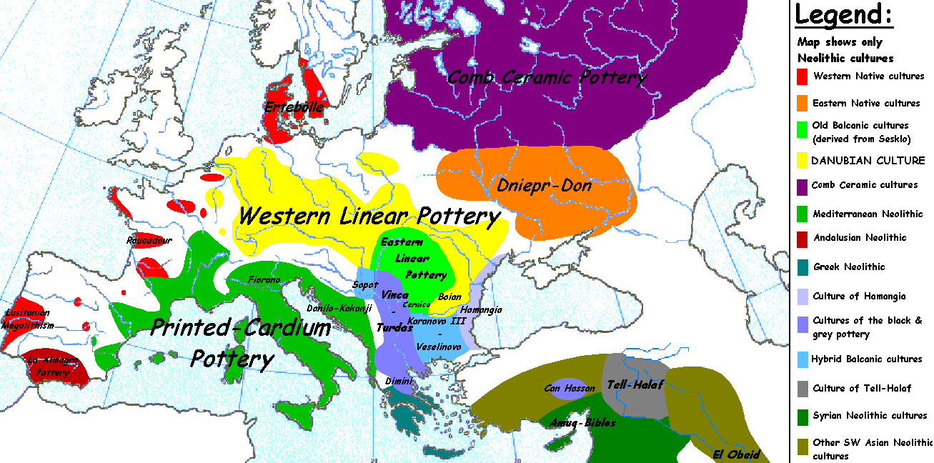
English: Map of the second half European Middle Neolithic at the apogee of Danubian and Mediterranean expansion. (The modification of the original map - Combed pottery, earlier notated as Pitted Ware, see history without respecting the color code of the legend is something that I am not fully satisfied with). |
| Dátum | 2005. április 5. (eredeti feltöltésének dátuma) |
| Forrás | Áthozva az en.wikipedia projektből a Commonsba. |
| Szerző |
Sugaar a(z) angol Wikipédia projektből Later versions were uploaded by Clarifer at en.wikipedia. |
| Más változatok |
[]
|


_en.png)
.png)
.jpg)
Licenc
| Sugaar a(z) angol Wikipédia projektből, a mű szerzője művét közkinccsé nyilvánította. Ez a világ minden részén érvényes. Egyes országokban ez jogilag nem lehetséges. Ha így van, akkor: Sugaar jogot ad bárkinek, hogy bármilyen célból, feltétel nélkül használhassa ezt a fájlt, kivéve a törvény által kötelezően előírt feltételeket. |
Eredeti feltöltési napló
Az eredeti leírólap itt volt. Az itt következő felhasználónevek az en.wikipedia projektre hivatkoznak.
- 2005-08-28 13:11 Clarifer 1320×663×8 (106148 bytes) Added the approximate area of the Comb Ceramic culture. Source: National Board of Antiquities, Finland. www.nba.fi
- 2005-04-05 20:12 Sugaar 1320×663×8 (103228 bytes) Map of the second half European Middle Neolithic at the apogee of Danubian and Mediterranean expansion (c. 4500-4000 BCE). Made by [[Sugaar]]. Free use authorized by the author.
Fájltörténet
Kattints egy időpontra, hogy a fájl akkori állapotát láthasd.
| Dátum/idő | Bélyegkép | Felbontás | Feltöltő | Megjegyzés | |
|---|---|---|---|---|---|
| aktuális | 2014. április 18., 08:43 | | 1 307 × 648 (101 KB) | Spiridon Ion Cepleanu | Neolithic shorelines and banks, little details |
| 2010. március 22., 02:39 |  | 1 307 × 648 (101 KB) | Ras67 | cropped | |
| 2007. február 14., 02:50 |  | 1 320 × 663 (104 KB) | 32X | Auf eine alte Version zurückgesetzt | |
| 2007. február 14., 02:49 |  | 1 320 × 663 (101 KB) | 32X | Original version by Sugaar. | |
| 2005. december 31., 13:14 |  | 1 320 × 663 (104 KB) | Glenn | Originally uploaded to en-wiki: Quote: "Map of the second half European Middle Neolithic at the apogee of Danubian and Mediterranean expansion (c. 4500-4000 BCE)." Upload text: "20:12, 5 April 2005 . . Sugaar . . 1320x663 (103228 bytes) (Map of the secon |
Fájlhasználat
Az alábbi lapok használják ezt a fájlt:
Globális fájlhasználat
A következő wikik használják ezt a fájlt:
- Használata itt: az.wikipedia.org
- Használata itt: be.wikipedia.org
- Használata itt: bg.wikipedia.org
- Használata itt: bs.wikipedia.org
- Használata itt: ca.wikipedia.org
- Használata itt: cs.wikipedia.org
- Használata itt: da.wikipedia.org
- Használata itt: da.wikibooks.org
- Használata itt: de.wikipedia.org
- Használata itt: en.wikipedia.org
- Használata itt: et.wikipedia.org
- Használata itt: fi.wikipedia.org
- Használata itt: fi.wikibooks.org
- Használata itt: gl.wikipedia.org
- Használata itt: he.wikipedia.org
- Használata itt: hi.wikipedia.org
- Használata itt: hr.wikipedia.org
- Használata itt: it.wikipedia.org
- Használata itt: ka.wikipedia.org
- Használata itt: lt.wikipedia.org
A fájl globális használatának megtekintése