
Fájl:Black Mesa and Lake Powell RR Map.png
Az előnézet mérete: 750 × 600 képpont További felbontások: 300 × 240 képpont | 600 × 480 képpont | 960 × 768 képpont | 1 280 × 1 024 képpont | 1 500 × 1 200 képpont.
Eredeti fájl (1 500 × 1 200 képpont, fájlméret: 109 KB, MIME-típus: image/png)
|
Ez a fájl a Wikimedia Commonsból származik. Az alább látható leírás az ottani dokumentációjának másolata. A Commons projekt szabad licencű kép- és multimédiatár. Segíts te is az építésében! |
Összefoglaló
| Leírás |
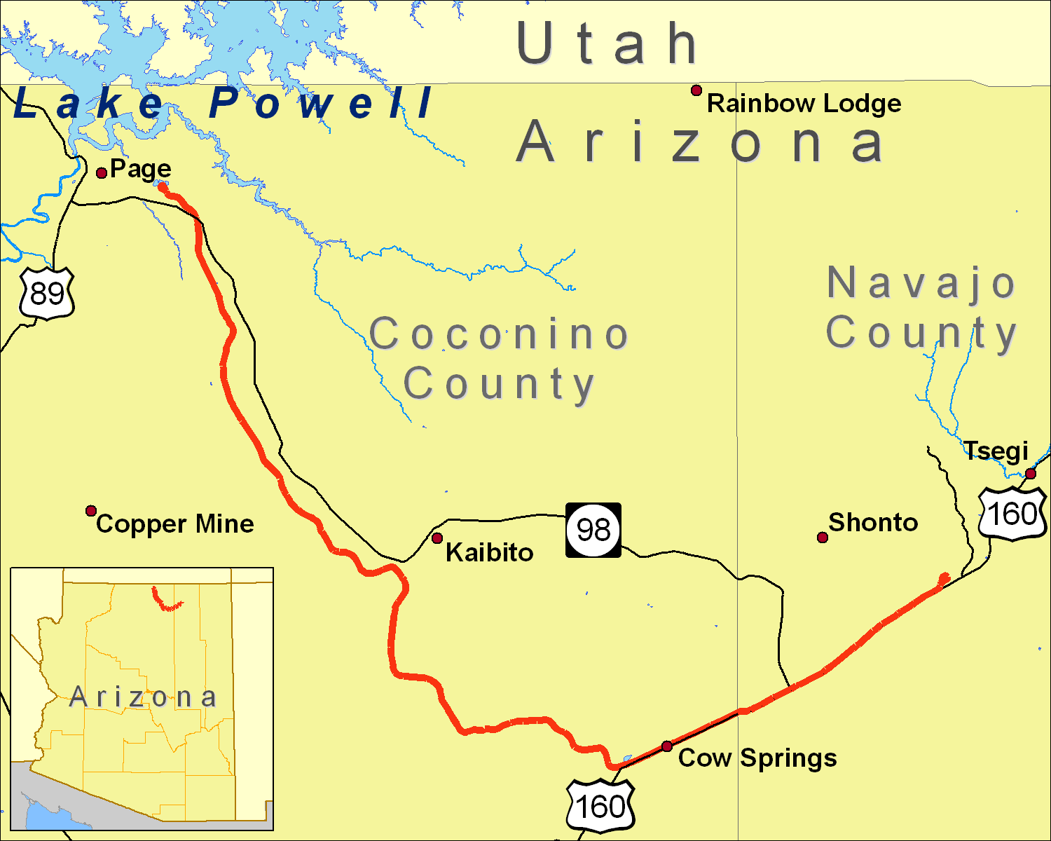
A map of the Black Mesa and Lake Powell Railroad extent, using data from the 2000 US Census TIGER Line file for railroads and roads (obtained from http://sdrsnet.srnr.arizona.edu/) and seamless.usgs.gov data. I created it using ArcGIS 9.1. |
| Dátum | 2006. december 19. (eredeti feltöltésének dátuma) |
| Forrás | Nincs megadva géppel olvasható forrás. Feltételezhetően saját munka (a szerzői jogi adatok alapján). |
| Szerző | Nincs megadva géppel olvasható szerző. Feltételezhetően Shorelander~commonswiki (a szerzői jogi adatok alapján). |

|
Ezt a képet el kellene készíteni vektorgrafika használatával SVG fájlként. A formátumnak számos előnye van; lásd a Commons:Media for cleanup lapot a további információkért. Ha a képnek már elérhető SVG-formátumú változata, töltsd fel. Az SVG feltöltése után cseréld le ezt a sablont a következőre: {{vector version available|új kép neve.svg}}.
|
Licenc
Én, e mű szerzője a művemet az alábbi licencek alatt teszem közzé:

|
Ez a fájl szabadon másolható, terjeszthető és/vagy módosítható a GNU Szabad Dokumentációs Licenc feltételei alapján, az 1.2 vagy későbbi, a Free Software Foundation által publikált Nem Változtatható szakaszok, Címlapszövegek és Hátlapszövegek nélküli változat szerint. E licenc egy példánya a GNU Szabad Dokumentációs Licenc című fejezetben olvasható. |
| Ez a fájl a Creative Commons Nevezd meg! – Így add tovább! 3.0 Unported licenc alapján használható fel. | ||
| ||
| Ez a licenc a GFDL licenccsere során került a fájlra. |
Ez a fájl a Creative Commons Nevezd meg! 2.5 Általános licenc alapján használható fel.
- A következőket teheted a művel:
- megoszthatod – szabadon másolhatod, terjesztheted, bemutathatod és előadhatod a művet
- feldolgozhatod – származékos műveket hozhatsz létre
- Az alábbi feltételekkel:
- Nevezd meg! – A szerzőt megfelelően fel kell tüntetned, hivatkozást kell létrehoznod a licencre és jelezned kell, ha a művön változtatást hajtottál végre. Ezt bármilyen észszerű módon megteheted, kivéve oly módon, ami azt sugallná hogy a jogosult támogat téged vagy a felhasználásod körülményeit.
A mű a fenti licencek bármelyike szerint felhasználható.
Fájltörténet
Kattints egy időpontra, hogy a fájl akkori állapotát láthasd.
| Dátum/idő | Bélyegkép | Felbontás | Feltöltő | Megjegyzés | |
|---|---|---|---|---|---|
| aktuális | 2007. január 19., 00:27 | | 1 500 × 1 200 (109 KB) | Shorelander~commonswiki | Another new version, with some extra tweaks and a new road. |
| 2006. december 21., 02:27 |  | 1 500 × 1 200 (109 KB) | Shorelander~commonswiki | New version, changing the size and fixing the spelling. | |
| 2006. december 19., 04:00 |  | 2 100 × 1 496 (218 KB) | Shorelander~commonswiki | A map of the Black Mesa and Lake Powell Railroad extent, using data from the 2000 US Census TIGER Line file for railroads and roads (obtained from http://sdrsnet.srnr.arizona.edu/) and seamless.usgs.gov data. I created it using ArcGIS 9.1. Shrunk and crop | |
| 2006. december 19., 03:37 |  | 6 300 × 4 500 (388 KB) | Shorelander~commonswiki | A map of the Black Mesa and Lake Powell Railroad extent, using data from the 2000 US Census TIGER Line file for railroads and roads (obtained from http://sdrsnet.srnr.arizona.edu/) and seamless.usgs.gov data. I created it using ArcGIS 9.1. |
Fájlhasználat
Az alábbi lap használja ezt a fájlt:
Globális fájlhasználat
A következő wikik használják ezt a fájlt:
- Használata itt: cs.wikipedia.org
- Használata itt: de.wikipedia.org
- Használata itt: en.wikipedia.org
- Használata itt: ja.wikipedia.org
- Használata itt: www.wikidata.org