
Fájl:A geographically correct map of Kansas & Colorado, showing principal cities & towns - DPLA - 1df17bed8f3a580557c9eadb0e0c5a64.jpg

Az előnézet mérete: 800 × 326 képpont További felbontások: 320 × 130 képpont | 640 × 261 képpont | 1 024 × 417 képpont | 1 280 × 521 képpont | 2 560 × 1 043 képpont | 9 000 × 3 666 képpont.
Eredeti fájl (9 000 × 3 666 képpont, fájlméret: 4,96 MB, MIME-típus: image/jpeg)
|
Ez a fájl a Wikimedia Commonsból származik. Az alább látható leírás az ottani dokumentációjának másolata. A Commons projekt szabad licencű kép- és multimédiatár. Segíts te is az építésében! |
Összefoglaló
This file was uploaded by the Digital Public Library of America, and the following item metadata was created by the contributing institution's staff.
Note: this data is being maintained by an automated bot, synced with the source data.
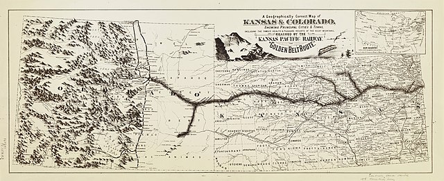
| Leírás | Brochure map promoting the Kansas Pacific Railway route to the Colorado gold fields. Text concerning the Kansas Pacific Railway Company, with time tables and one illustration. Maps on verso. Date is estimated. | ||||||||||||||||||||
| Title | A geographically correct map of Kansas & Colorado, showing principal cities & towns, A geographically correct map of Kansas & Colorado, showing principal cities & towns, including the famous health & pleasure resorts of the Rocky Mountains, reached by the Kansas Pacific Railway, the "Golden Belt Route"; Our country with a few leading R.R. lines, designed to show the commercial position of Kansas City, Mo; Fertile, thrifty, growing Kansas; healty, grand, attractive Colorado; Free! Take a correct county map of Kansas Pacific Railway, Kansas and Colorado | ||||||||||||||||||||
| Institution |
|
||||||||||||||||||||
| Subject | |||||||||||||||||||||
| Forrás |
Plains to Peaks Collective |
||||||||||||||||||||
| Szerző |
Kansas Pacific Railway Company |
||||||||||||||||||||
| Engedély (Fájl újrafelhasználása) |
Copyright determination made by Denver Public Library (Q69470198) using RightsStatements.org
|
||||||||||||||||||||
| Partnership |
|
||||||||||||||||||||


Fájltörténet
Kattints egy időpontra, hogy a fájl akkori állapotát láthasd.
| Dátum/idő | Bélyegkép | Felbontás | Feltöltő | Megjegyzés | |
|---|---|---|---|---|---|
| aktuális | 2020. december 18., 15:36 | 9 000 × 3 666 (4,96 MB) | DPLA bot | Uploading DPLA ID 1df17bed8f3a580557c9eadb0e0c5a64 |
Fájlhasználat
Az alábbi lap használja ezt a fájlt:
Globális fájlhasználat
A következő wikik használják ezt a fájlt:
- Használata itt: en.wikipedia.org