Fájl:Valencia, Spain.jpg

Eredeti fájl (10 002 × 10 001 képpont, fájlméret: 160,07 MB, MIME-típus: image/jpeg)
|
Ez a fájl a Wikimedia Commonsból származik. Az alább látható leírás az ottani dokumentációjának másolata. A Commons projekt szabad licencű kép- és multimédiatár. Segíts te is az építésében! |
Összefoglaló
| Figyelem | Néhány böngészőnek problémát jelenthet ezen kép teljes felbontásban történő megjelenítése. Mivel a szokásosnál is több pixelből áll, ezért lehet, hogy nem töltődik be helyesen, vagy lefagyasztja a böngészőt. |
|---|
| LeírásValencia, Spain.jpg |
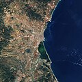
English: The Copernicus Sentinel-2 satellite takes us over the city of Valencia and its stunning blue coast. Situated on the east coast of the Iberian Peninsula, Valencia is the third largest city in Spain after Madrid and Barcelona.
The city is visible in the centre of the image, flanked by the Mediterranean Sea on one side and overlooked by the mountains of Sierra Calderona to the north. As a significant cultural centre for the country, it is home to the futuristic City of Arts and Sciences complex, which also hosts Oceanografic – the biggest aquarium in Europe. Just 10 km south of the city, this true-colour image shows us the Albufera freshwater lagoon in green. Separated by a narrow strip of coastline featuring sand dunes and Mediterranean pine forest, three canals connect the lagoon and surrounding wetlands with the sea. The area is home to huge numbers of both migratory and resident birds, including rare species such as Eurasian Bittern. The area is also thought to be the home of the world-famous Paella dish, with the traditional rice used for the dish grown in the surrounding fields since the 19th century. On the right of the image, amidst the waves and popcorn clouds, we can see a boat, possibly travelling to the port of Valencia from one of the nearby Balearic Islands – a popular route for tourists and residents of the city alike. The region of Valencia is famous for the diversity of its landscapes, covering mountains, beaches, wetlands and semi-arid desert environments within a total area of less than 25 0000 sq km. This diversity is clearly highlighted in the Sentinel-2 image. Sentinel-2 data can be used to monitor agriculture, biodiversity, and coastal and inland waters for Europe’s Copernicus environmental monitoring programme. This satellite image will be shown atIGARRS– the International Geoscience and Remote Sensing Symposium, held in Valencia from 22–27 July. The theme for this year’s symposium highlights the pressing demands for ‘observing, understanding and forecasting the dynamics of our planet’. This image, which was captured on 9 August 2017, is also featured on theEarth from Space programme. |
| Dátum | |
| Forrás | http://www.esa.int/spaceinimages/Images/2018/07/Valencia_Spain |
| Szerző | European Space Agency |
| Engedély (Fájl újrafelhasználása) |
contains modified Copernicus Sentinel data (2017), processed by ESA ,CC BY-SA 3.0 IGO |
| Más változatok |
|
| Title InfoField | Valencia, Spain |
| System InfoField | Copernicus |
| Set InfoField | Earth observation image of the week |
| Mission InfoField | Sentinel-2 |
| Activity InfoField | Observing the Earth |
Licenc
- A következőket teheted a művel:
- megoszthatod – szabadon másolhatod, terjesztheted, bemutathatod és előadhatod a művet
- feldolgozhatod – származékos műveket hozhatsz létre
- Az alábbi feltételekkel:
- Nevezd meg! – A szerzőt megfelelően fel kell tüntetned, hivatkozást kell létrehoznod a licencre és jelezned kell, ha a művön változtatást hajtottál végre. Ezt bármilyen észszerű módon megteheted, kivéve oly módon, ami azt sugallná hogy a jogosult támogat téged vagy a felhasználásod körülményeit.
- Így add tovább! – Ha megváltoztatod, átalakítod, feldolgozod ezt a művet, a közreműködésedet csak az eredetivel megegyező vagy hasonló licenc alatt terjesztheted.


|
This image contains data from a satellite in the Copernicus Programme, such as Sentinel-1, Sentinel-2 or Sentinel-3. Attribution is required when using this image.
Így nevezd meg: Contains modified Copernicus Sentinel data {{{year}}}
Attribution
The use of Copernicus Sentinel Data is regulated under EU law (Commission Delegated Regulation (EU) No 1159/2013 and Regulation (EU) No 377/2014). Relevant excerpts:
Free access shall be given to GMES dedicated data [...] made available through GMES dissemination platforms [...].
Access to GMES dedicated data [...] shall be given for the purpose of the following use in so far as it is lawful:
GMES dedicated data [...] may be used worldwide without limitations in time.
GMES dedicated data and GMES service information are provided to users without any express or implied warranty, including as regards quality and suitability for any purpose. |
Attribution
Képaláírások
A fájl által ábrázolt elemek
mű tárgya
20. július 2018
image/jpeg
Fájltörténet
Kattints egy időpontra, hogy a fájl akkori állapotát láthasd.
| Dátum/idő | Bélyegkép | Felbontás | Feltöltő | Megjegyzés | |
|---|---|---|---|---|---|
| aktuális | 2021. február 8., 04:48 |  | 10 002 × 10 001 (160,07 MB) | StellarHalo | Uploaded a work by European Space Agency from http://www.esa.int/spaceinimages/Images/2018/07/Valencia_Spain with UploadWizard |
Fájlhasználat
Ezt a fájlt nem használja egyetlen lap sem.
Globális fájlhasználat
A következő wikik használják ezt a fájlt:
- Használata itt: de.wikipedia.org
- Használata itt: en.wikipedia.org
- Használata itt: es.wikipedia.org
- Használata itt: ig.wikipedia.org
Metaadatok
Ez a kép járulékos adatokat tartalmaz, amelyek feltehetően a kép létrehozásához használt digitális fényképezőgép vagy lapolvasó beállításairól adnak tájékoztatást. Ha a képet az eredetihez képest módosították, ezen adatok eltérhetnek a kép tényleges jellemzőitől.
| Színösszetevők | RGB |
|---|---|
| Tájolás | Normál |
| Vízszintes felbontás | 72 dpi |
| Függőleges felbontás | 72 dpi |
| Használt szoftver | Adobe Photoshop CC 2018 (Windows) |
| Utolsó változtatás ideje | 2018. július 9., 15:41 |
| Digitalizálás dátuma és időpontja | 2018. június 5., 11:08 |
| Színtér | sRGB |
| Dátum metaadat utolsó módosítása | 2018. július 9., 17:41 |
| Eredeti dokumentum egyedi azonosítója | xmp.did:3086c798-960c-ae4a-be3c-4a5c9a43f304 |
| IIM-verzió | 2 |

