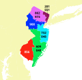
Fájl:USA telephone area code map - New Jersey.svg

Ennek a(z) SVG fájlnak ezen PNG formátumú előnézete: 189 × 360 képpont. További felbontások: 126 × 240 képpont | 252 × 480 képpont | 403 × 768 képpont | 537 × 1 024 képpont | 1 075 × 2 048 képpont.
Eredeti fájl (SVG fájl, névlegesen 189 × 360 képpont, fájlméret: 3,66 MB)
Fájltörténet
Kattints egy időpontra, hogy a fájl akkori állapotát láthasd.
| Dátum/idő | Bélyegkép | Felbontás | Feltöltő | Megjegyzés | |
|---|---|---|---|---|---|
| aktuális | 2023. július 31., 19:22 |  | 189 × 360 (3,66 MB) | Kbrose | crop to smaller canvas |
| 2019. június 25., 14:57 |  | 435 × 417 (3,67 MB) | Kbrose | correct number placement | |
| 2017. július 22., 15:37 |  | 435 × 417 (3,67 MB) | Psiĥedelisto | Overlayed new area code 640 over 609 | |
| 2017. január 16., 08:38 |  | 408 × 391 (3,65 MB) | Psiĥedelisto | fix wrong color of area code 609 barrier islands which was masked by outlines in previous version of image | |
| 2016. december 3., 23:45 |  | 408 × 391 (3,65 MB) | Kbrose | Remove black emphasis of border lines | |
| 2016. december 2., 18:37 |  | 408 × 391 (3,67 MB) | Psiĥedelisto | I have gotten some feedback that my font choice was lacking - so this time I went for just `sans-serif` over Computer Modern. Apologies to Knuth ;) | |
| 2016. december 2., 16:42 |  | 408 × 391 (3,75 MB) | Psiĥedelisto | {{Information |Description ={{en|1={{PD-author|USGS, shapefile found here: http://gis.ucla.edu/geodata/dataset/north-america-telephone-area-code-boundaries}} {{Created with QGIS}} {{Created with Inkscape}} {{User:Psiĥedelisto/This_template_is_inclu... |
Fájlhasználat
Ezt a fájlt nem használja egyetlen lap sem.
Globális fájlhasználat
A következő wikik használják ezt a fájlt:
- Használata itt: en.wikipedia.org
- Használata itt: es.wikipedia.org
- Használata itt: fr.wikipedia.org
- Használata itt: zh.wikipedia.org


