
Fájl:Spanish-Arabic map of 1109.jpg
Spanish-Arabic_map_of_1109.jpg (500 × 392 képpont, fájlméret: 77 KB, MIME-típus: image/jpeg)
|
Ez a fájl a Wikimedia Commonsból származik. Az alább látható leírás az ottani dokumentációjának másolata. A Commons projekt szabad licencű kép- és multimédiatár. Segíts te is az építésében! |
Összefoglaló
| Leírás |
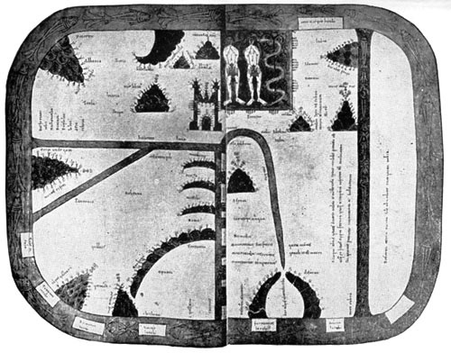
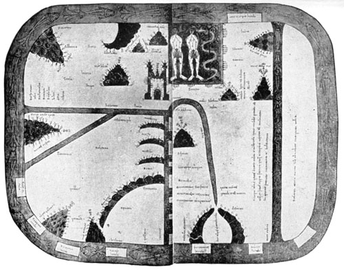
English: Spanish-Arabic map of 1109 (B. Mus., Add. mss., 11695). The original, gorgeously coloured, represents the crudest of Christian and Moslem notions of the world. Even more crude than in the Turin map and the Mappe-Monde of St. Sever, both of which offer some resemblances to this. The earth is represented as of quadrangular shape, surrounded by the ocean. At the E. is Paradise with the figures of the Temptation. A part of the S. is cut off by the Red Sea, which is straight (and coloured red), just as the straight Mediterranean, with its quadrangular islands, divides the N.W. quarter, or Europe, from the S.W. quarter, or Africa. The Ægean Sea joins the Mediterranean at a right angle, in the centre of the map. In the ocean, bordering the whole, are square islands, e.g., Tile (Thule), Britania, Scocia, Fu(o)rtunarum insula. The Turin map occurs in another copy of the same work—A Commentary on the Apocalypse. (Source:http://www.gutenberg.org/files/18757/18757-h/) |
| Dátum | |
| Forrás | http://www.gutenberg.org/files/18757/18757-h/images/map06.jpg |
| Szerző | Ismeretlen |
T-O map with the earthly Garden of Eden at the top
Összefoglaló
|
Ez a mű közkincs abban az országban, ahol elkészítették, és minden olyan további államban, ahol a szerzői jogi védelmi idő a szerző élete plusz 100 év vagy kevesebb. | |
| Megállapították, hogy ez a fájl mentes mindenféle szerzői jogi korlátozástól, beleértve az összes kapcsolódó és hozzátartozó jogot. | |
Fájltörténet
Kattints egy időpontra, hogy a fájl akkori állapotát láthasd.
| Dátum/idő | Bélyegkép | Felbontás | Feltöltő | Megjegyzés | |
|---|---|---|---|---|---|
| aktuális | 2009. június 11., 15:12 | | 500 × 392 (77 KB) | Before My Ken | enhanced visibility |
| 2009. február 24., 03:33 |  | 500 × 392 (66 KB) | Goustien | {{Information |Description={{en|1=Spanish-Arabic map of 1109}} |Source=http://www.gutenberg.org/files/18757/18757-h/images/map06.jpg |Author=unknown |Date=1109 |Permission={{PD-old}} |other_versions= }} T-O map with Eden at the top <!--{{ImageUpload|full} |
Fájlhasználat
Ezt a fájlt nem használja egyetlen lap sem.
Globális fájlhasználat
A következő wikik használják ezt a fájlt:
- Használata itt: en.wikipedia.org
- Használata itt: fa.wikipedia.org
- Használata itt: mk.wikipedia.org
- Használata itt: ro.wikipedia.org