
Fájl:RomaniaBorderHistoryAnnimation 1859-2010.gif
Az előnézet mérete: 696 × 599 képpont További felbontások: 279 × 240 képpont | 558 × 480 képpont | 1 000 × 861 képpont.
Eredeti fájl (1 000 × 861 képpont, fájlméret: 162 KB, MIME-típus: image/gif, ismétlődik, 12 képkocka, 36 s)
|
Ez a fájl a Wikimedia Commonsból származik. Az alább látható leírás az ottani dokumentációjának másolata. A Commons projekt szabad licencű kép- és multimédiatár. Segíts te is az építésében! |
Összefoglaló
| Leírás |
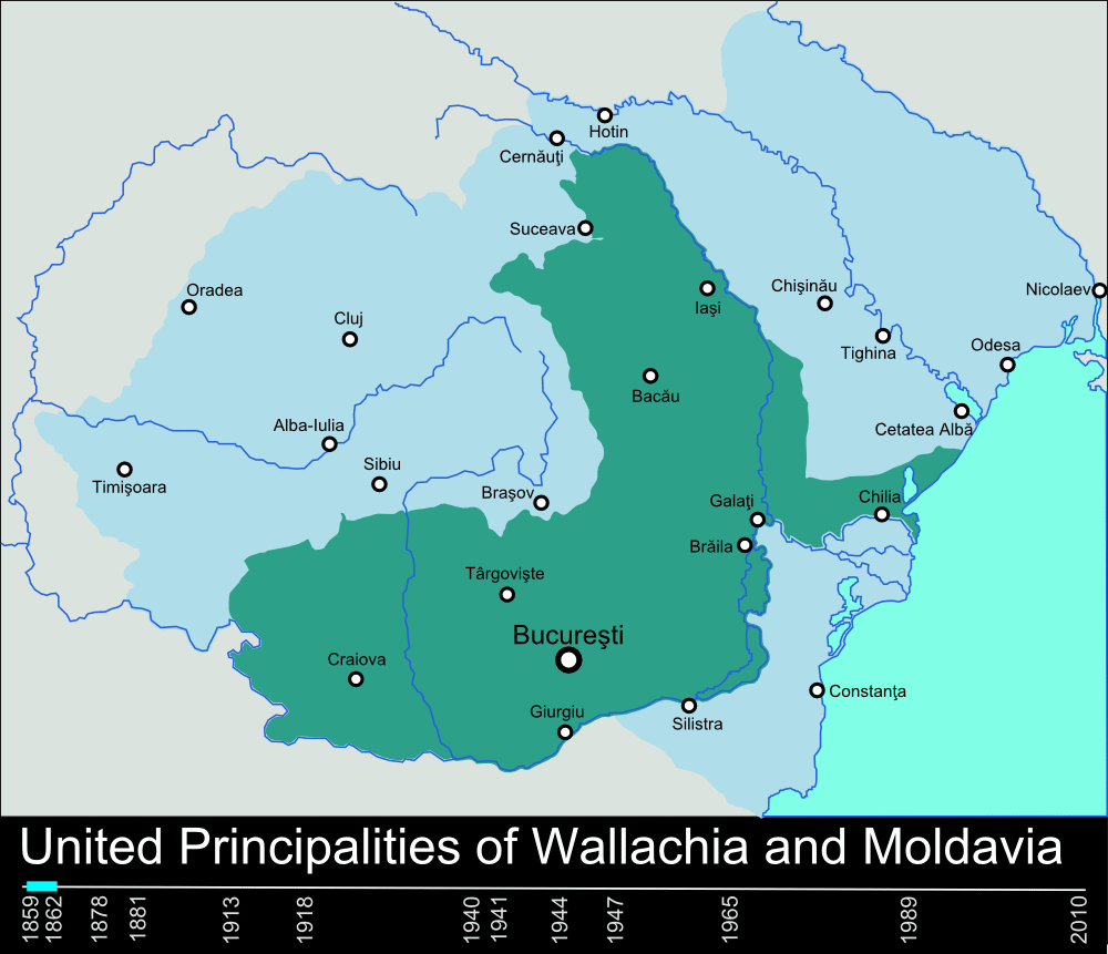
English: Timeline of the borders of Romania between 1859 and 2010. |
| Dátum | 2010. január 11. (eredeti feltöltésének dátuma) |
| Forrás | self-made, individual frames were based on maps from here: Atlas of Romania. (I could upload standalone maps for each period of time, if needed. Contact me for that.). |
| Szerző | User:Scooter20 |
| Más változatok | Származékos művek: RomaniaBorderHistoryAnnimation 1859-2010 es.gif |
Licenc
| Scooter20 a(z) angol Wikipédia projektből, a mű szerzője művét közkinccsé nyilvánította. Ez a világ minden részén érvényes. Egyes országokban ez jogilag nem lehetséges. Ha így van, akkor: Scooter20 jogot ad bárkinek, hogy bármilyen célból, feltétel nélkül használhassa ezt a fájlt, kivéve a törvény által kötelezően előírt feltételeket. |
Eredeti feltöltési napló
Áthozta Rowanwindwhistler az en.wikipedia projektből a Commonsba CommonsHelper használatával.
Az eredeti leírólap itt volt. Az itt következő felhasználónevek az en.wikipedia projektre hivatkoznak.
- 2010-01-11 22:17 Scooter20 1000×861× (166899 bytes) Reverted to version as of 12:48, 31 December 2009
- 2010-01-10 21:53 Alexandrey 1000×861× (152174 bytes) Reverted to version as of 19:31, 30 December 2009
- 2010-01-10 21:52 Alexandrey 1000×861× (166932 bytes) Reverted to version as of 12:29, 31 December 2009
- 2009-12-31 12:48 Scooter20 1000×861× (166899 bytes) fixed Hertza region, which didn't belong to Romania after 1944
- 2009-12-31 12:29 Scooter20 1000×861× (166932 bytes) Added new intervals: 1862-1878, 1878-1881 - United Romanian Principalities 1947-1965 - People's Republic of Romania
- 2009-12-31 00:57 Scooter20 1000×861× (153234 bytes) fixed location of the city of Sibiu
- 2009-12-30 19:31 Scooter20 1000×861× (152174 bytes) Timeline of the borders of Romania between 1859 and 2010.
Fájltörténet
Kattints egy időpontra, hogy a fájl akkori állapotát láthasd.
| Dátum/idő | Bélyegkép | Felbontás | Feltöltő | Megjegyzés | |
|---|---|---|---|---|---|
| aktuális | 2012. március 10., 00:02 | | 1 000 × 861 (162 KB) | Scooter20 | Better colors! |
| 2010. szeptember 8., 18:07 |  | 1 000 × 861 (168 KB) | Mihai Andrei | Corrected the name of the city of Cluj for the period until 1975. | |
| 2010. szeptember 4., 02:09 |  | 1 000 × 861 (163 KB) | Anonimizat XXX | (I tried to revert to the version from april 2010 but it didn't work, so I've decided to manually upload again) | |
| 2010. szeptember 4., 02:02 |  | 1 000 × 861 (163 KB) | Anonimizat XXX | Reverted to version as of 20:45, 21 April 2010 (animation broken, also, the name of Cluj is actually Cluj-Napoca as the original gif indicate) | |
| 2010. augusztus 9., 20:02 |  | 1 000 × 861 (73 KB) | Mihai Andrei | Corrected the name of the city of Cluj. | |
| 2010. április 21., 22:45 |  | 1 000 × 861 (163 KB) | File Upload Bot (Magnus Manske) | {{BotMoveToCommons|en.wikipedia|year={{subst:CURRENTYEAR}}|month={{subst:CURRENTMONTHNAME}}|day={{subst:CURRENTDAY}}}} {{Information |Description={{en|Timeline of the borders of Romania between 1859 and 2010.<br/> == Other versions == [[:en:Image:Flag_of |
Fájlhasználat
Ezt a fájlt nem használja egyetlen lap sem.
Globális fájlhasználat
A következő wikik használják ezt a fájlt:
- Használata itt: af.wikipedia.org
- Használata itt: ar.wikipedia.org
- Használata itt: ary.wikipedia.org
- Használata itt: ast.wikipedia.org
- Használata itt: azb.wikipedia.org
- Használata itt: bcl.wikipedia.org
- Használata itt: da.wikipedia.org
- Használata itt: de.wikipedia.org
- Használata itt: el.wikipedia.org
- Használata itt: en.wikipedia.org
- Romania
- History of Romania
- Former administrative divisions of Romania
- Kingdom of Romania
- Romanians
- Administrative divisions of Romania
- Portal:Romania
- User:Scooter20
- Union of Transylvania with Romania
- User:Iadrian yu
- User talk:Iadrian yu/Archive April,2010
- Territorial evolution of Romania
- 2010 in Romania
- Használata itt: et.wikipedia.org
- Használata itt: eu.wikipedia.org
- Használata itt: fa.wikipedia.org
- Használata itt: fi.wikipedia.org
- Használata itt: it.wikipedia.org
- Használata itt: ja.wikipedia.org
- Használata itt: ka.wikipedia.org
- Használata itt: lv.wikipedia.org
- Használata itt: mk.wikipedia.org
- Használata itt: no.wikipedia.org
- Használata itt: pt.wikipedia.org
- Használata itt: ro.wikibooks.org
- Használata itt: ru.wikipedia.org
A fájl globális használatának megtekintése