
Fájl:Red Sea map.svg

Ennek a(z) SVG fájlnak ezen PNG formátumú előnézete: 220 × 282 képpont. További felbontások: 187 × 240 képpont | 374 × 480 képpont | 599 × 768 képpont | 799 × 1 024 képpont | 1 598 × 2 048 képpont.
Eredeti fájl (SVG fájl, névlegesen 220 × 282 képpont, fájlméret: 1,61 MB)
|
Ez a fájl a Wikimedia Commonsból származik. Az alább látható leírás az ottani dokumentációjának másolata. A Commons projekt szabad licencű kép- és multimédiatár. Segíts te is az építésében! |
Összefoglaló
| Leírás |
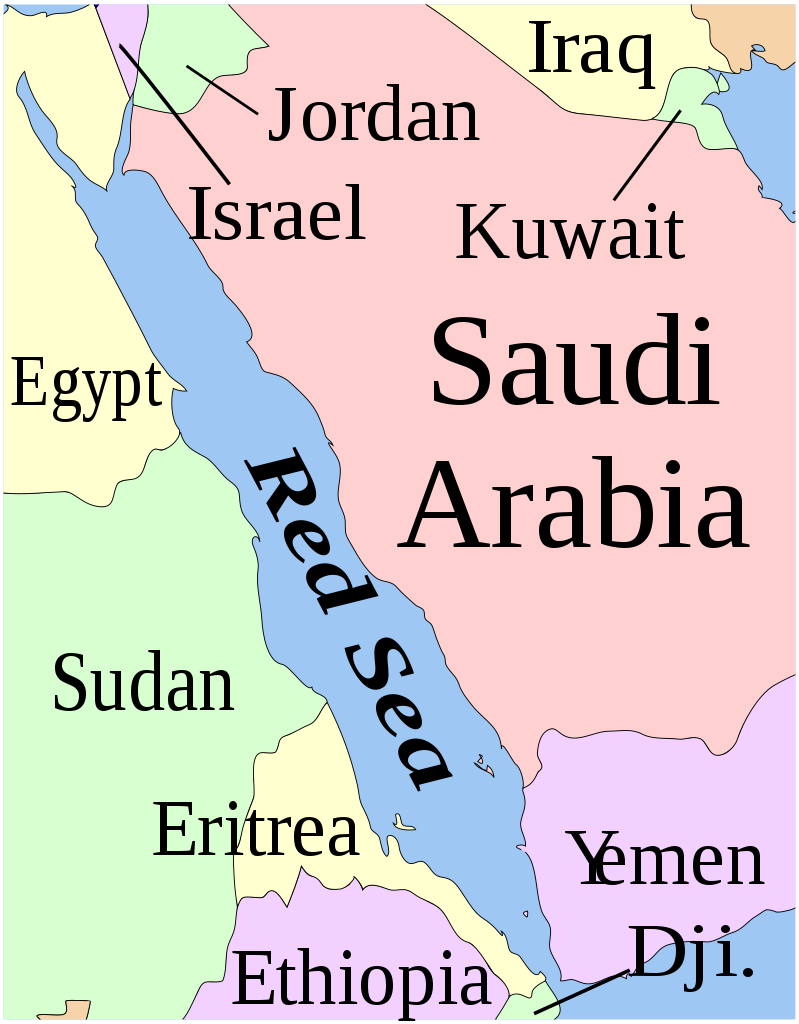
English: A four-colour map of the Red Sea |
| Dátum | (UTC) |
| Forrás |
Ez a fájl ebből származik: BlankMap-World6.svg: |
| Szerző |
|
| Más változatok |
[]
|


| Ez egy retusált kép, ami azt jelenti, hogy az eredetihez képest digitálisan módosították. Módosítások: Cropped, added colors and text. Az eredeti itt található: BlankMap-World6.svg. Módosította: Presidentman.
|
Licenc
Én, e mű szerzője a művemet az alábbi licenc alatt teszem közzé:
| Én, a szerző, ezt a művemet ezennel közkinccsé nyilvánítom. Ez a világ minden részén érvényes. Egyes országokban ez jogilag nem lehetséges. Ha így van, akkor: Jogot adok bárkinek, hogy bármilyen célból, feltétel nélkül használhassa ezt a fájlt, kivéve a törvény által kötelezően előírt feltételeket. |
Eredeti feltöltési napló
This image is a derivative work of the following images:
- File:BlankMap-World6.svg licensed with PD-self
- 2013-06-05T18:47:10Z U+003F 863x443 (1619935 Bytes) Consolidated class definitions
- 2013-05-19T12:42:20Z U+003F 863x443 (1620274 Bytes) As below. The map seems not to have been replaced with the new version.
- 2013-05-18T20:25:36Z U+003F 863x443 (1621109 Bytes) Take 2. Added a element to name country, with the official name derived using existing 2-character [[w:ISO 3166-1 alpha-2|ISO 3166-1 alpha-2]] code. These country names will be displayed (in most browsers) when hovered over.
- 2013-05-18T20:21:34Z U+003F 863x443 (1621109 Bytes) Added a element to name country, with the official name derived using existing 2-character [w:ISO 3166-1 alpha-2|ISO 3166-1 alpha-2]] code. These country names will be displayed (in most browsers) when hovered over.
- 2012-12-11T10:09:32Z Konstantin Burov 863x443 (1654809 Bytes) Cleansed Inkscape tags so the file now passes W3G SVG validation, converted all relative coordinates into absolute so the file is parsable by the nugsl-worldmap script again. Fixed version of the script is available at [https
- 2012-11-30T16:49:28Z Yug 863x443 (1654809 Bytes) [[user:Konstantin_Burov]]'s fixes. I help her/him for this upload.
- 2012-10-30T00:27:03Z Chipmunkdavis 863x443 (1609186 Bytes) Reverted to version as of 13:37, 14 February 2012 POV pushing, neither Moroccos recognised borders, nor its de facto ones
- 2012-10-28T20:14:49Z Apolikamixitos 863x443 (1650219 Bytes) Fixing Morocco borders
- 2012-02-14T13:37:02Z Tentotwo 863x443 (1609186 Bytes) Removed hardcoded styles from sd, ss, and cf
- 2012-01-06T03:22:35Z Spesh531 863x443 (1651067 Bytes) Fixing South Sudan's border
- 2011-12-19T00:04:12Z Chipmunkdavis 863x443 (1612580 Bytes) Reverted to version as of 00:51, 27 August 2011
- 2011-12-18T15:14:45Z Anshulkumardhiman 1920x1080 (320804 Bytes) fixed background
- 2011-12-18T15:06:50Z Anshulkumardhiman 1920x1080 (323987 Bytes) fixed color texture
- 2011-08-27T00:51:14Z Anomie 863x443 (1612580 Bytes) South Sudan has been assigned code SS, so use that code.
- 2011-07-30T18:04:36Z Lokal Profil 863x443 (1612578 Bytes) Minor circle related changes and remove the legacy pentagram
- 2011-07-08T23:26:24Z NuclearVacuum 863x443 (1613386 Bytes) South Sudan is free!! Hooray
- 2011-07-04T20:41:30Z NuclearVacuum 863x443 (1615589 Bytes) Restored to previous version, as SS isn't independent yet. But the code is now ready and waiting
- 2011-07-04T20:40:06Z NuclearVacuum 863x443 (1613386 Bytes) Separated South Sudan from (North) Sudan in preparation for SS independence on July 9, 2011.
- 2011-06-27T15:15:14Z Canuckguy 863x443 (1615589 Bytes) restored PR, set id labels for West Bank and Gaza
- 2011-04-01T14:09:57Z NuclearVacuum 863x443 (1614917 Bytes) Mayotte is now a department of France
- 2011-02-17T14:31:36Z NuclearVacuum 863x443 (1614903 Bytes) minor fixes
- 2011-02-13T01:43:20Z Canuckguy 863x443 (1632654 Bytes) minor fix
- 2011-01-22T20:16:24Z NuclearVacuum 863x443 (1614900 Bytes) added lakes
- 2011-01-22T20:12:02Z NuclearVacuum 863x443 (1632622 Bytes) ...
- 2011-01-22T20:08:04Z NuclearVacuum 863x443 (1632651 Bytes) Reverted to version as of 18:31, 17 January 2011
- 2011-01-22T20:07:39Z NuclearVacuum 1173x937 (334238 Bytes) just testing something
- 2011-01-17T18:31:33Z NuclearVacuum 863x443 (1632651 Bytes) minor fix of Sudan
- 2011-01-17T18:26:18Z NuclearVacuum 863x443 (1632651 Bytes) minor fix
- 2011-01-17T18:17:24Z NuclearVacuum 863x443 (1632633 Bytes) clean code
- 2011-01-17T18:12:07Z NuclearVacuum 863x443 (1632625 Bytes) added new class of circles, added Southern Sudan as a region within Sudan.
- 2011-01-15T00:06:15Z NuclearVacuum 863x443 (1631574 Bytes) minor fix
- 2011-01-14T23:51:44Z NuclearVacuum 863x443 (1631571 Bytes) added missing regions of the European Union
- 2011-01-13T14:26:50Z NuclearVacuum 863x443 (1631559 Bytes) minor fix
- 2011-01-13T14:17:57Z NuclearVacuum 863x443 (1631550 Bytes) added the BES Islands to the Netherladns
- 2011-01-07T21:02:08Z NuclearVacuum 863x443 (1631333 Bytes) minor fix
- 2011-01-07T20:55:32Z NuclearVacuum 863x443 (1631333 Bytes) corrected code for the circles
- 2011-01-06T16:44:29Z NuclearVacuum 863x443 (1208206 Bytes) removed all but 5px of whitespace, see talk page
- 2011-01-03T14:03:40Z NuclearVacuum 854x433 (1208195 Bytes) Curaçao and Sint Maarten have been given codes
- 2011-01-02T03:21:03Z Tomchen1989 854x433 (1205379 Bytes) compromised for the bug
- 2010-12-28T01:58:24Z Kintetsubuffalo 853x433 (1205378 Bytes) what are you talking about? nothing is cut off or squished
- 2010-12-28T00:28:42Z NuclearVacuum 940x477 (1631321 Bytes) Reverted to version as of 16:43, 27 October 2010
- 2010-12-19T20:10:58Z Tomchen1989 853x433 (1205378 Bytes) stroke-width of coast
- 2010-12-19T08:51:57Z Tomchen1989 853x433 (1205378 Bytes) minor change
- 2010-12-16T16:14:47Z Tomchen1989 853x433 (1205378 Bytes) radius of the circles changed
- 2010-12-14T22:57:20Z Tomchen1989 853x433 (1208461 Bytes) small fixed
- 2010-12-14T22:36:00Z Tomchen1989 853x433 (1208830 Bytes) had outside whitespace removed; cleaned the code; used tab indent
- 2010-10-27T16:43:23Z NuclearVacuum 940x477 (1631321 Bytes) fixed as part of discussion
- 2010-10-24T03:54:05Z NuclearVacuum 940x477 (1630960 Bytes) I fixed the code so it is valid
- 2010-10-10T22:06:16Z Canuckguy 940x477 (1630991 Bytes) Reverted to version as of 02:01, 18 September 2010 (Neth. Antilles removed, Sint Maarten and Curacao added, Bonaire part of "nl")
- 2010-09-18T02:01:50Z Canuckguy 940x477 (1630802 Bytes) Reverted to version as of 01:03, 9 July 2010. New version to be used October 10, 2010
Uploaded with derivativeFX
Fájltörténet
Kattints egy időpontra, hogy a fájl akkori állapotát láthasd.
| Dátum/idő | Bélyegkép | Felbontás | Feltöltő | Megjegyzés | |
|---|---|---|---|---|---|
| aktuális | 2016. december 26., 22:35 | | 220 × 282 (1,61 MB) | Hydrargyrum | toned-down four-color scheme; adjust text sizes; replace font with Liberation Serif; add layers |
| 2013. július 30., 18:13 |  | 40 × 52 (1,45 MB) | Presidentman | change EXIF data | |
| 2013. július 30., 18:04 |  | 40 × 52 (1,45 MB) | Presidentman | == {{int:filedesc}} == {{Information |Description={{en|1=A map of the Red Sea}} |Source={{Derived from|BlankMap-World6.svg|display=50}} |Date=2013-07-30 16:03 (UTC) |Author=*File:BlankMap-World6.svg: Canuckguy <small>([[w:e... |
Fájlhasználat
Ezt a fájlt nem használja egyetlen lap sem.
Globális fájlhasználat
A következő wikik használják ezt a fájlt:
- Használata itt: bn.wikipedia.org
- Használata itt: en.wikipedia.org
- Használata itt: id.wikipedia.org
- Használata itt: ko.wikipedia.org
- Használata itt: zh.wikipedia.org