
Fájl:Nile River Delta at Night.JPG

Eredeti fájl (4 256 × 2 832 képpont, fájlméret: 2,05 MB, MIME-típus: image/jpeg)
|
Ez a fájl a Wikimedia Commonsból származik. Az alább látható leírás az ottani dokumentációjának másolata. A Commons projekt szabad licencű kép- és multimédiatár. Segíts te is az építésében! |
Összefoglaló
| Leírás |
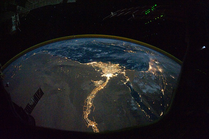
English: In this view of Egypt, we see a population almost completely concentrated along the Nile Valley, just a small percentage of the country’s land area. The Nile River and its delta look like a brilliant, long-stemmed flower in this astronaut photograph of the south-eastern Mediterranean Sea, as seen from the International Space Station. The Cairo metropolitan area forms a particularly bright base of the flower. The smaller cities and towns within the Nile Delta tend to be hard to see amidst the dense agricultural vegetation during the day. However, these settled areas and the connecting roads between them become clearly visible at night. Likewise, urbanized regions and infrastructure along the Nile River becomes apparent.
Another brightly lit region is visible along the eastern coastline of the Mediterranean—the Tel-Aviv metropolitan area in Israel (image right). To the east of Tel-Aviv lies Amman, Jordan. The two major water bodies that define the western and eastern coastlines of the Sinai Peninsula—the Gulf of Suez and the Gulf of Aqaba—are outlined by lights along their coastlines (image lower right). The city lights of Paphos, Limassol, Larnaca, and Nicosia are visible on the island of Cyprus (image top). Scattered blue-grey clouds cover the Mediterranean Sea and the Sinai, while much of north-eastern Africa is cloud-free. A thin yellow-brown band tracing the Earth’s curvature at image top is air-glow, a faint band of light emission that results from the interaction of atmospheric atoms and molecules with solar radiation at approximately 100 kilometres altitude. |
| Dátum | |
| Forrás | NASA Earth Observatory |
| Szerző | ISS Expedition 25 crew |
| Más változatok |
Származékos művek: Nile River Delta at Night cropped.JPG Also see http://earthobservatory.nasa.gov/IOTD/view.php?id=46820&src=eoa-iotd for annotated version, with features identified. |
| Fényképező elhelyezkedése | | További képek erről a helyről: OpenStreetMap |
|---|
Ezt a képet vagy videót az Amerikai Egyesült Államok Nemzeti Légügyi és Űrhajózási Hivatalának (NASA) Johnson Űrközpontjakategorizálta a következő azonosító kód alatt: fénykép-azonosító: ISS025-E-9858. Ez a sablon nem a licenc jelölésére szolgál. Szükség van egy licencsablonra is. Lásd a Commons:Licencelés lapot. Más nyelvek:
|
Image acquired with a Nikon D3S digital camera using a 16 mm lens, and is provided by the ISS Crew Earth Observations experiment and Image Science & Analysis Laboratory, Johnson Space Center.
Licenc
| Ezt a fájlt a NASA készítette, ezért az Egyesült Államokban közkincsnek számít. A NASA szerzői jogi irányelve alapján „a NASA anyagai nem állnak szerzői jogi védelem alatt, kivéve, ha az külön jelezve van". (Lásd még: Sablon:PD-USGov, a NASA szerzői jogi- és a JPL képhasználati irányelve.) | ||
 |
Figyelmeztetések:
|
| Képjegyzetek | Ehhez a képhez képjegyzetek tartoznak: Képjegyzetek megtekintése a Commonson |
Fájltörténet
Kattints egy időpontra, hogy a fájl akkori állapotát láthasd.
| Dátum/idő | Bélyegkép | Felbontás | Feltöltő | Megjegyzés | |
|---|---|---|---|---|---|
| aktuális | 2010. november 8., 14:51 | | 4 256 × 2 832 (2,05 MB) | Originalwana | {{Information |Description={{en|1=In this view of Egypt, we see a population almost completely concentrated along the Nile Valley, just a small percentage of the country’s land area. The Nile River and its delta look like a brilliant, long-stemmed flow |
Fájlhasználat
Ezt a fájlt nem használja egyetlen lap sem.
Globális fájlhasználat
A következő wikik használják ezt a fájlt:
- Használata itt: af.wikipedia.org
- Használata itt: arz.wikipedia.org
- Használata itt: av.wikipedia.org
- Használata itt: bg.wikipedia.org
- Használata itt: bs.wikipedia.org
- Használata itt: cs.wikipedia.org
- Használata itt: el.wikipedia.org
- Használata itt: en.wikipedia.org
- Használata itt: en.wiktionary.org
- Használata itt: es.wikipedia.org
- Használata itt: ha.wikipedia.org
- Használata itt: he.wikipedia.org
- Használata itt: incubator.wikimedia.org
- Használata itt: ln.wikipedia.org
- Használata itt: ml.wikipedia.org
- Használata itt: no.wikipedia.org
- Használata itt: sd.wikipedia.org
- Használata itt: sk.wikipedia.org
- Használata itt: sl.wikipedia.org
- Használata itt: sq.wikipedia.org
- Használata itt: sq.wikiquote.org
- Használata itt: sr.wikipedia.org
- Használata itt: sv.wikipedia.org
- Használata itt: ta.wikipedia.org
- Használata itt: th.wikipedia.org
- Használata itt: tr.wikipedia.org
- Használata itt: uk.wikipedia.org
- Használata itt: ur.wikipedia.org
- Használata itt: vi.wikipedia.org