
Fájl:Map of Israel, neighbours and occupied territories.svg

Eredeti fájl (SVG fájl, névlegesen 559 × 721 képpont, fájlméret: 650 KB)
|
Ez a fájl a Wikimedia Commonsból származik. Az alább látható leírás az ottani dokumentációjának másolata. A Commons projekt szabad licencű kép- és multimédiatár. Segíts te is az építésében! |
Összefoglaló
| Leírás |
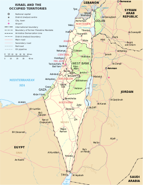
English: Map of the Middle East showing Israel, Egypt, Saudi Arabia, Jordan, Syria and Lebanon including Gaza, Golan Heights and West Bank.
العربية: خريطة دولة إسرائيل والأراضي الفلسطينية التي تشمل الضفة الغربية وقطاع غزة والجولان السوري المحتل. |
| Dátum | |
| Forrás | SVG extracted and edited from PDF |
| Szerző | un.org |
| Más változatok | македонски |
| SVG kód | Ez vektorgrafikus kép Inkscape segítségével készült. |
Licenc
| Ez a kép egy ENSZ általi térképet ábrázol.
Ha nincs más feltüntetve, az ENSZ térképei közkincsnek számítanak. Ez az egész világon érvényes. Az ENSZ térképei szabadon felhasználhatók. Viszont arra kérnek, hogy módosítás után távolítsd el az ENSZ nevét, logóját és a térkép azonosítóját. A térképed tartalmáért neked kell felelősséget vállalnod. Ha szeretnéd megjelölheted a forrást, a következő módon: az alábbi ENSZ-térképen alapul: … (név, azonosító, változat száma és dátum). Lásd még: Az ENSZ Térképészeti Részlege (hozzáférés ideje: 2016. október 30.) |
 |
| Én, a szerző, ezt a művemet ezennel közkinccsé nyilvánítom. Ez a világ minden részén érvényes. Egyes országokban ez jogilag nem lehetséges. Ha így van, akkor: Jogot adok bárkinek, hogy bármilyen célból, feltétel nélkül használhassa ezt a fájlt, kivéve a törvény által kötelezően előírt feltételeket. |
Fájltörténet
Kattints egy időpontra, hogy a fájl akkori állapotát láthasd.
| Dátum/idő | Bélyegkép | Felbontás | Feltöltő | Megjegyzés | |
|---|---|---|---|---|---|
| aktuális | 2023. október 7., 18:07 | | 559 × 721 (650 KB) | LametinoWiki | File uploaded using svgtranslate tool (https://svgtranslate.toolforge.org/). Added translation for it. |
| 2023. október 7., 18:07 |  | 559 × 721 (650 KB) | LametinoWiki | File uploaded using svgtranslate tool (https://svgtranslate.toolforge.org/). Added translation for it. | |
| 2022. december 27., 03:49 |  | 559 × 721 (596 KB) | Wikijahnn | File uploaded using svgtranslate tool (https://svgtranslate.toolforge.org/). Added translation for ca. | |
| 2022. december 27., 03:46 |  | 559 × 721 (596 KB) | Wikijahnn | File uploaded using svgtranslate tool (https://svgtranslate.toolforge.org/). Added translation for ca. | |
| 2018. május 5., 19:09 |  | 559 × 721 (540 KB) | FrankieF | Reverted to version as of 23:22, 5 March 2018 (UTC). Replaces a bad and blurred map without distance meter to a crisp and clear map. | |
| 2018. március 10., 20:47 |  | 559 × 721 (285 KB) | Eric's son | The last version is outdated and factually incorrect. Reverted to version as of 21:50, 26 February 2018 (UTC) | |
| 2018. március 6., 01:22 |  | 559 × 721 (540 KB) | Nableezy | Reverted to version as of 16:20, 12 December 2011 (UTC) make a different map, dont replace every other with this one | |
| 2018. február 26., 23:50 |  | 559 × 721 (285 KB) | Eric's son | small graphic fixes | |
| 2018. február 20., 00:24 |  | 559 × 721 (259 KB) | Eric's son | Adding relevant updates (evacuated UN zones), clear colored borders explained in legend. | |
| 2011. december 12., 18:20 |  | 559 × 721 (540 KB) | Ch1902 | =={{int:filedesc}}== {{Information |Description={{en|1=Map of the Middle East showing Israel, Egypt, Saudi Arabia, Jordan, Syria and Lebanon including Gaza, Golan Heights and West Bank.}} |Source=SVG extracted and edited from [http://www.un.org/Depts/Car |
Fájlhasználat
Ezt a fájlt nem használja egyetlen lap sem.
Globális fájlhasználat
A következő wikik használják ezt a fájlt:
- Használata itt: ary.wikipedia.org
- Használata itt: azb.wikipedia.org
- Használata itt: bxr.wikipedia.org
- Használata itt: ca.wikipedia.org
- Használata itt: da.wikipedia.org
- Használata itt: en.wikipedia.org
- Használata itt: ga.wikipedia.org
- Használata itt: gl.wikipedia.org
- Használata itt: hy.wikipedia.org
- Használata itt: it.wikipedia.org
- Használata itt: kn.wikipedia.org
- Használata itt: ko.wikipedia.org
- Használata itt: nl.wikipedia.org
- Használata itt: pap.wikipedia.org
- Használata itt: pnb.wikipedia.org
- Használata itt: ru.wikipedia.org
- Használata itt: sr.wikipedia.org
- Használata itt: sv.wikipedia.org
- Használata itt: www.wikidata.org