
Fájl:Iceberg A22A, South Atlantic Ocean.jpg

Az előnézet mérete: 800 × 530 képpont További felbontások: 320 × 212 képpont | 640 × 424 képpont | 1 024 × 678 képpont | 1 280 × 848 képpont | 2 345 × 1 553 képpont.
Eredeti fájl (2 345 × 1 553 képpont, fájlméret: 793 KB, MIME-típus: image/jpeg)
|
Ez a fájl a Wikimedia Commonsból származik. Az alább látható leírás az ottani dokumentációjának másolata. A Commons projekt szabad licencű kép- és multimédiatár. Segíts te is az építésében! |
Összefoglaló
| Leírás |
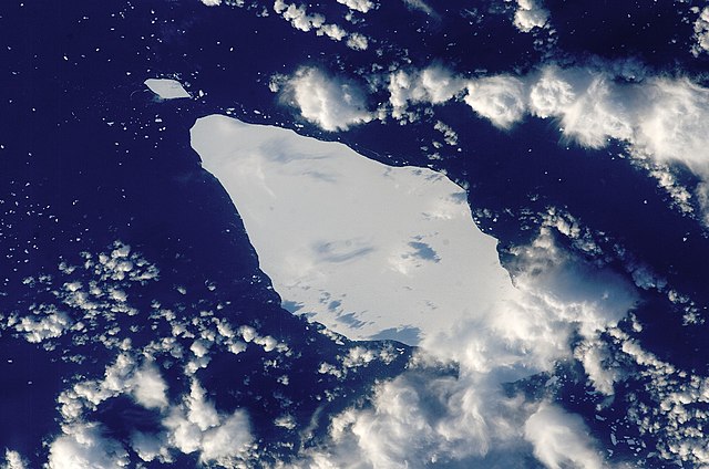
English: This astronaut photograph illustrates the remains of a giant iceberg—designated A22A— that broke off Antarctica in 2002. The iceberg was photographed at a location of 49.9 degrees south latitude, 23.8 degrees west longitude, which is about a third of the distance from South America towards Cape Town, South Africa. A22A is one of the largest icebergs to drift as far north as 50 degrees south latitude, bringing it beneath the daylight path of the International Space Station (ISS). Crew members aboard the ISS were able to locate the ice mass and photograph it, despite the great masses of clouds that often accompany winter storms in the Southern Ocean. The crew’s viewing angle was oblique (not looking straight down) from a point to the west of the berg, and the time of day was early afternoon, as shown by the orientation of the cloud shadows. Dimensions of A22A in early June were 49.9 by 23.4 kilometres, giving it an area of 622 square kilometres, or seven times the area of Manhattan Island.
|
||||||||||||||||||||||||||||||||||||||||||||||||||
| Dátum | |||||||||||||||||||||||||||||||||||||||||||||||||||
| Forrás | {{URL|example.com|optional display text}} | ||||||||||||||||||||||||||||||||||||||||||||||||||
| Szerző | Image provided by the ISS Crew Earth Observations experiment and the Image Science & Analysis Laboratory, NASA - Johnson Space Center. | ||||||||||||||||||||||||||||||||||||||||||||||||||
| Objektum elhelyezkedése | | További képek erről a helyről: OpenStreetMap |
|---|
Ezt a képet vagy videót az Amerikai Egyesült Államok Nemzeti Légügyi és Űrhajózási Hivatalának (NASA) Johnson Űrközpontjakategorizálta a következő azonosító kód alatt: fénykép-azonosító: ISS015-E-10125. Ez a sablon nem a licenc jelölésére szolgál. Szükség van egy licencsablonra is. Lásd a Commons:Licencelés lapot. Más nyelvek:
|
Licenc
| Ezt a fájlt a NASA készítette, ezért az Egyesült Államokban közkincsnek számít. A NASA szerzői jogi irányelve alapján „a NASA anyagai nem állnak szerzői jogi védelem alatt, kivéve, ha az külön jelezve van". (Lásd még: Sablon:PD-USGov, a NASA szerzői jogi- és a JPL képhasználati irányelve.) | ||
 |
Figyelmeztetések:
|
Fájltörténet
Kattints egy időpontra, hogy a fájl akkori állapotát láthasd.
| Dátum/idő | Bélyegkép | Felbontás | Feltöltő | Megjegyzés | |
|---|---|---|---|---|---|
| aktuális | 2013. március 22., 17:25 | | 2 345 × 1 553 (793 KB) | Julian Herzog | Higher resolution and quality |
| 2009. július 5., 21:54 |  | 1 000 × 1 000 (376 KB) | Originalwana | {{Information |Description={{en|1=This astronaut photograph illustrates the remains of a giant iceberg—designated A22A— that broke off Antarctica in 2002. The iceberg was photographed at a location of 49.9 degrees south latitude, 23.8 degrees west lon |
Fájlhasználat
Ezt a fájlt nem használja egyetlen lap sem.
Globális fájlhasználat
A következő wikik használják ezt a fájlt:
- Használata itt: ar.wikipedia.org
- Használata itt: az.wikipedia.org
- Használata itt: bn.wikipedia.org
- Használata itt: cy.wikipedia.org
- Használata itt: en.wikipedia.org
- Használata itt: eo.wikipedia.org
- Használata itt: it.wikipedia.org
- Használata itt: it.wikibooks.org
- Használata itt: it.wikiversity.org
- Használata itt: la.wikipedia.org
- Használata itt: mk.wikipedia.org
- Használata itt: pt.wikipedia.org
- Használata itt: sl.wikipedia.org
- Használata itt: ta.wikipedia.org
- Használata itt: ta.wiktionary.org
- Használata itt: th.wikipedia.org