
Fájl:FrontLines Environment Photo Contest Winner -5 (5808476109).jpg
Az előnézet mérete: 800 × 534 képpont További felbontások: 320 × 214 képpont | 640 × 427 képpont | 1 024 × 683 képpont | 1 280 × 854 képpont.
Eredeti fájl (1 280 × 854 képpont, fájlméret: 432 KB, MIME-típus: image/jpeg)
|
Ez a fájl a Wikimedia Commonsból származik. Az alább látható leírás az ottani dokumentációjának másolata. A Commons projekt szabad licencű kép- és multimédiatár. Segíts te is az építésében! |
.jpg)
Összefoglaló
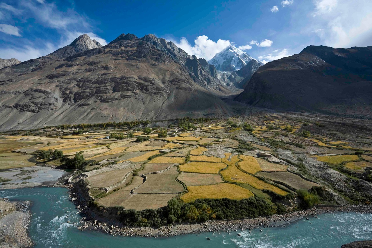
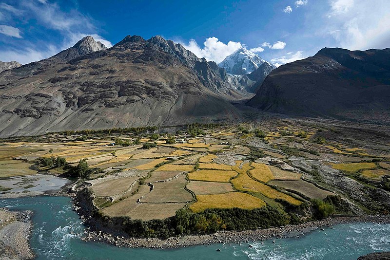
| Leírás | Here, a dramatic view of flood plain cultivation in Wakhan, Afghanistan. Known as "the roof of the world," the Wildlife Conservation Society says the Wakhan Corridor has few rivals in terms of scenic beauty. The little-known area is nestled in the high Pamir Mountains and the region is flanked by the Hindu Kush, Himalayn, Karakoram, and Kunlun ranges. Credit: John Winnie Jr., WCS-Afghanistan |
| Dátum | |
| Forrás | FrontLines Environment Photo Contest Winner #5 |
| Szerző | USAID U.S. Agency for International Development |
| Fényképező elhelyezkedése | | További képek erről a helyről: OpenStreetMap |
|---|
.jpg¶ms=036.952778_N_0072.962500_E_globe:Earth_type:camera__&language=hu)
| Objektum elhelyezkedése | | További képek erről a helyről: OpenStreetMap |
|---|
.jpg¶ms=036.951111_N_0072.962778_E_globe:Earth_class:object_type:object__&language=hu)
A fájl földrajzi helyzete utólag lett megbecsülve,
ami emiatt kissé pontatlan lehet. Erősen javasolt ezen koordináták ellenőrzése és finomítása. |
- Notes on location estimate
- Identify village by shape of the farm field
Licenc
This image is a work of a United States Agency for International Development employee, taken or made as part of that person's official duties. As a work of the U.S. federal government, the image is in the public domain in the United States.
See also: The USAID privacy policy and the USAID Office of Inspector General "Disclaimers & Notices" page
|
 |
| This image was originally posted to Flickr by USAID_IMAGES at https://flickr.com/photos/46658241@N06/5808476109. It was reviewed on 2017. január 4. by FlickreviewR and was confirmed to be licensed under the terms of the United States Government Work. |
Fájltörténet
Kattints egy időpontra, hogy a fájl akkori állapotát láthasd.
| Dátum/idő | Bélyegkép | Felbontás | Feltöltő | Megjegyzés | |
|---|---|---|---|---|---|
| aktuális | 2017. január 4., 04:06 | | 1 280 × 854 (432 KB) | Reguyla | Transferred from Flickr via Flickr2Commons |
Fájlhasználat
Ezt a fájlt nem használja egyetlen lap sem.
Globális fájlhasználat
A következő wikik használják ezt a fájlt:
- Használata itt: arz.wikipedia.org
- Használata itt: be.wikipedia.org
- Használata itt: bg.wikipedia.org
- Használata itt: ca.wikipedia.org
- Használata itt: ceb.wikipedia.org
- Használata itt: cs.wikipedia.org
- Használata itt: de.wikipedia.org
- Használata itt: de.wikivoyage.org
- Használata itt: el.wikipedia.org
- Használata itt: en.wikipedia.org
- Használata itt: en.wikivoyage.org
- Használata itt: eo.wikipedia.org
- Használata itt: es.wikipedia.org
- Használata itt: eu.wikipedia.org
- Használata itt: fa.wikipedia.org
- Használata itt: he.wikivoyage.org
- Használata itt: ja.wikipedia.org
- Használata itt: pl.wikipedia.org
- Használata itt: pl.wiktionary.org
- Használata itt: ru.wikipedia.org
- Használata itt: ru.wikinews.org
- Használata itt: sv.wikipedia.org
- Használata itt: ta.wikipedia.org
- Használata itt: uk.wikipedia.org
- Használata itt: ur.wikipedia.org
- Használata itt: www.wikidata.org
- Használata itt: zh.wikipedia.org
.jpg)