
Fájl:Fonseca gulf.jpg

Az előnézet mérete: 615 × 600 képpont További felbontások: 246 × 240 képpont | 492 × 480 képpont | 640 × 624 képpont.
Eredeti fájl (640 × 624 képpont, fájlméret: 109 KB, MIME-típus: image/jpeg)
|
Ez a fájl a Wikimedia Commonsból származik. Az alább látható leírás az ottani dokumentációjának másolata. A Commons projekt szabad licencű kép- és multimédiatár. Segíts te is az építésében! |
Összefoglaló
| Leírás |
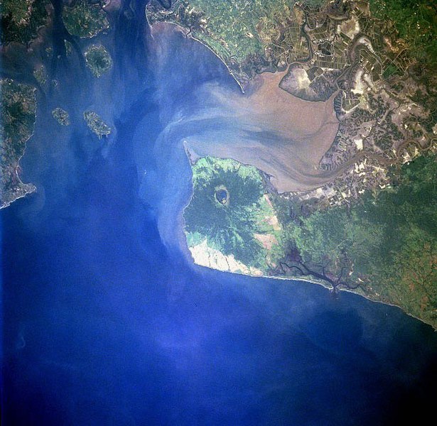
Gulf of Fonseca, El Salvador, Honduras, Nicaragua |
| Dátum | |
| Forrás | eol.jsc.nasa.gov |
| Szerző | NASA |
| Más változatok |
.jpg)
Licenc
| Ezt a fájlt a NASA készítette, ezért az Egyesült Államokban közkincsnek számít. A NASA szerzői jogi irányelve alapján „a NASA anyagai nem állnak szerzői jogi védelem alatt, kivéve, ha az külön jelezve van". (Lásd még: Sablon:PD-USGov, a NASA szerzői jogi- és a JPL képhasználati irányelve.) | ||
 |
Figyelmeztetések:
|
Fájltörténet
Kattints egy időpontra, hogy a fájl akkori állapotát láthasd.
| Dátum/idő | Bélyegkép | Felbontás | Feltöltő | Megjegyzés | |
|---|---|---|---|---|---|
| aktuális | 2022. november 22., 11:40 | | 640 × 624 (109 KB) | SteinsplitterBot | Bot: Image rotated by 270° |
| 2005. december 10., 06:10 |  | 631 × 640 (110 KB) | Thuresson | Gulf of Fonseca, El Salvador, Honduras, Nicaragua - July 1997 *Image courtesy of the Image Science & Analysis Laboratory, NASA Johnson Space Center. *Source: [http://eol.jsc.nasa.gov/sseop/EFS/photoinfo.pl?PHOTO=STS094-723-83 eol.jsc.nasa.gov] *Photo #: |
Fájlhasználat
Ezt a fájlt nem használja egyetlen lap sem.
Globális fájlhasználat
A következő wikik használják ezt a fájlt:
- Használata itt: de.wikipedia.org
- Használata itt: el.wikipedia.org
- Használata itt: en.wikipedia.org
- Használata itt: eo.wikipedia.org
- Használata itt: es.wikipedia.org
- Használata itt: fr.wikipedia.org
- Használata itt: gl.wikipedia.org
- Használata itt: it.wikipedia.org
- Használata itt: ja.wikipedia.org
- Használata itt: lt.wikipedia.org
- Használata itt: nl.wikipedia.org
- Használata itt: pl.wikipedia.org
- Használata itt: pt.wikipedia.org
- Használata itt: ru.wikipedia.org
- Használata itt: sk.wikipedia.org
- Használata itt: uk.wikipedia.org
- Használata itt: www.wikidata.org