
Fájl:China Hong Kong 4 levels localisation.svg

Ennek a(z) SVG fájlnak ezen PNG formátumú előnézete: 705 × 599 képpont. További felbontások: 282 × 240 képpont | 565 × 480 képpont | 904 × 768 képpont | 1 205 × 1 024 képpont | 2 409 × 2 048 képpont | 1 000 × 850 képpont.
Eredeti fájl (SVG fájl, névlegesen 1 000 × 850 képpont, fájlméret: 703 KB)
|
Ez a fájl a Wikimedia Commonsból származik. Az alább látható leírás az ottani dokumentációjának másolata. A Commons projekt szabad licencű kép- és multimédiatár. Segíts te is az építésében! |
| Leírás |
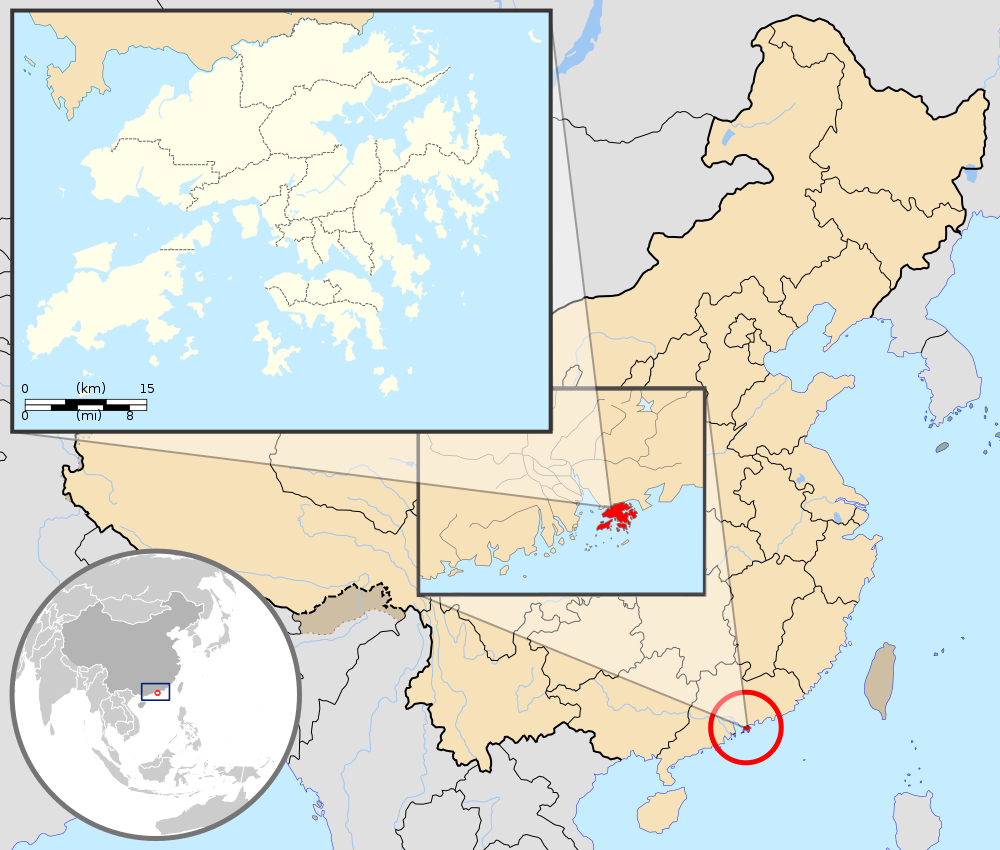
English: Map showing Hong Kong's location in Asia, on China's south coast, and Hong Kong's 18 districts
Français : Carte de Hong Kong : situation en Asie, situation sur le littoral chinois, carte des 18 districts
中文(繁體):顯示香港在亞洲,中國南海岸和香港18區的位置的地圖 |
| Dátum | (UTC) |
| Forrás |
Ez vektorgrafikus kép Inkscape segítségével készült . |
| Szerző |
|
| Más változatok | Származékos művek: Hebao island map.jpg |
| Ez egy retusált kép, ami azt jelenti, hogy az eredetihez képest digitálisan módosították. Módosítások: Combination, color correction. Az eredeti itt található: China Hong Kong.svg. Módosította: Pethrus.
|
Ez a fájl a Creative Commons Nevezd meg! – Így add tovább! 3.0 Unported licenc alapján használható fel.
Így nevezd meg: GFDL
- A következőket teheted a művel:
- megoszthatod – szabadon másolhatod, terjesztheted, bemutathatod és előadhatod a művet
- feldolgozhatod – származékos műveket hozhatsz létre
- Az alábbi feltételekkel:
- Nevezd meg! – A szerzőt megfelelően fel kell tüntetned, hivatkozást kell létrehoznod a licencre és jelezned kell, ha a művön változtatást hajtottál végre. Ezt bármilyen észszerű módon megteheted, kivéve oly módon, ami azt sugallná hogy a jogosult támogat téged vagy a felhasználásod körülményeit.
- Így add tovább! – Ha megváltoztatod, átalakítod, feldolgozod ezt a művet, a közreműködésedet csak az eredetivel megegyező vagy hasonló licenc alatt terjesztheted.
Eredeti feltöltési napló
This image is a derivative work of the following images:
- File:Hong_Kong_Location.svg licensed with PD-self
- 2008-08-27T13:27:11Z Joowwww 1270x640 (234741 Bytes) a few minor tweaks
- 2008-08-27T13:18:03Z Joowwww 1270x640 (234389 Bytes) new version: more detailed, colours are standard with most other locator maps
- 2008-04-20T13:54:51Z Joowwww 1270x640 (79729 Bytes) reduced height, removed map border and added rivers and hk's maritime border
- 2008-04-09T11:31:22Z Joowwww 1270x977 (66085 Bytes) {{Information |Description=A map showing Hong Kong's location in Asia, in China and on China's south coast. |Source=self-made |Date=2008-04-09 |Author= [[User:Joowwww|Joowwww]] |Permission={{PD-self}} |other_versions= }} {{Cr
- File:Map_of_Hong_Kong_18Districts_ZH.svg licensed with Cc-by-sa-3.0, GFDL
- 2008-07-05T21:14:26Z Moddlyg 1454x1083 (381097 Bytes) == Summary == {{Information |Description={{en|1=Map of Hong Kong & 18 Districts (Chinese Version)}} |Source=Own work by uploader |Author={{User:Moddlyg/Sign}} |Date=2008/7/6 |Permission= |other_versions= }} {{ImageUpload|ful
- 2008-07-05T20:59:35Z Moddlyg 1454x1083 (262750 Bytes) {{Information |Description={{en|1=Map of Hong Kong & 18 Districts (Chinese Version)}} |Source=Own work by uploader |Author=~~~ |Date=2008/7/6 |Permission= |other_versions= }}
- File:China_Hong_Kong.svg licensed with PD-self
- 2008-08-13T16:22:08Z Joowwww 1000x850 (212124 Bytes) added missing laos/vietnam border
- 2008-05-14T11:14:46Z Joowwww 1000x850 (210515 Bytes) {{Information |Description=An SVG map of China with Hong Kong special administrative region highlighted and circled Legend:[[Image:China map legend.png]] |Source=self-made; based on CIA public domain maps: *http://www.lib.ut
Uploaded with derivativeFX
Fájltörténet
Kattints egy időpontra, hogy a fájl akkori állapotát láthasd.
| Dátum/idő | Bélyegkép | Felbontás | Feltöltő | Megjegyzés | |
|---|---|---|---|---|---|
| aktuális | 2019. szeptember 22., 23:33 | | 1 000 × 850 (703 KB) | En rouge | added map scale, for the higher resolution sub-picture |
| 2015. május 14., 09:57 |  | 1 000 × 850 (686 KB) | Flappiefh | Fixed colour of Haïnan. | |
| 2010. március 5., 20:40 |  | 1 000 × 850 (685 KB) | Pethrus | {{Information |Description={{en|1=Map showing Hong Kong's location in Asia, on China's south coast, and Hong Kong's 18 disctricts}} {{fr|1=Carte de Hong Kong : situation en Asie, situation sur le littoral chinois, carte des 18 disctricts}} |Source=*[[:Fil |
Fájlhasználat
Ezt a fájlt nem használja egyetlen lap sem.
Globális fájlhasználat
A következő wikik használják ezt a fájlt:
- Használata itt: ami.wikipedia.org
- Használata itt: as.wikipedia.org
- Használata itt: azb.wikipedia.org
- Használata itt: bh.wikipedia.org
- Használata itt: bo.wikipedia.org
- Használata itt: br.wikipedia.org
- Használata itt: cbk-zam.wikipedia.org
- Használata itt: dty.wikipedia.org
- Használata itt: dz.wikipedia.org
- Használata itt: en.wikipedia.org
- Használata itt: fi.wikipedia.org
- Használata itt: fr.wikipedia.org
- Használata itt: fr.wikinews.org
- Használata itt: fr.wiktionary.org
- Használata itt: fur.wikipedia.org
- Használata itt: gcr.wikipedia.org
- Használata itt: gn.wikipedia.org
- Használata itt: incubator.wikimedia.org
- Használata itt: io.wikipedia.org
- Használata itt: it.wikipedia.org
- Használata itt: ja.wikipedia.org
- Használata itt: li.wikipedia.org
- Használata itt: lld.wikipedia.org
- Használata itt: lo.wikipedia.org
- Használata itt: mad.wikipedia.org
- Használata itt: mai.wikipedia.org
A fájl globális használatának megtekintése