
Fájl:2019-11-26 Mamurras, Albania M6.4 earthquake shakemap (USGS).jpg
Az előnézet mérete: 471 × 600 képpont További felbontások: 188 × 240 képpont | 377 × 480 képpont | 786 × 1 001 képpont.
Eredeti fájl (786 × 1 001 képpont, fájlméret: 388 KB, MIME-típus: image/jpeg)
|
Ez a fájl a Wikimedia Commonsból származik. Az alább látható leírás az ottani dokumentációjának másolata. A Commons projekt szabad licencű kép- és multimédiatár. Segíts te is az építésében! |
.jpg)
Összefoglaló
| Leírás | |
| Dátum | |
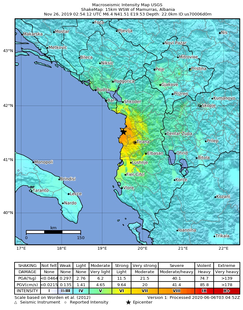
| Forrás | https://earthquake.usgs.gov/earthquakes/eventpage/us70006d0m |
| Szerző | United States Geological Survey |
Licenc
This image is in the public domain in the United States because it only contains materials that originally came from the United States Geological Survey, an agency of the United States Department of the Interior. For more information, see the official USGS copyright policy.
|
Fájltörténet
Kattints egy időpontra, hogy a fájl akkori állapotát láthasd.
| Dátum/idő | Bélyegkép | Felbontás | Feltöltő | Megjegyzés | |
|---|---|---|---|---|---|
| aktuális | 2020. szeptember 2., 13:34 | | 786 × 1 001 (388 KB) | IllCom | New Version by USGS |
| 2019. december 19., 02:04 |  | 799 × 1 027 (384 KB) | Cewbot | Import USGS updated earthquake map, shakemap id: urn:usgs-product:us:shakemap:us70006d0m:1576710484988 (2019-12-18T23:08:04.988Z) | |
| 2019. november 28., 08:03 |  | 799 × 1 027 (384 KB) | Cewbot | Import USGS updated earthquake map, shakemap id: urn:usgs-product:us:shakemap:us70006d0m:1574918746692 (2019-11-28T05:25:46.692Z) | |
| 2019. november 27., 06:03 |  | 799 × 1 027 (384 KB) | Cewbot | Import USGS updated earthquake map, shakemap id: urn:usgs-product:us:shakemap:us70006d0m:1574823443193 (2019-11-27T02:57:23.193Z) | |
| 2019. november 26., 08:03 |  | 799 × 1 027 (384 KB) | Cewbot | Import USGS updated earthquake map, shakemap id: urn:usgs-product:us:shakemap:us70006d0m:1574744239038 (2019-11-26T04:57:19.038Z) | |
| 2019. november 26., 06:05 |  | 799 × 1 027 (384 KB) | Cewbot | Import USGS earthquake map, shakemap id: urn:usgs-product:us:shakemap:us70006d0m:1574739829558 (2019-11-26T03:43:49.558Z) |
Fájlhasználat
Az alábbi lap használja ezt a fájlt:
Globális fájlhasználat
A következő wikik használják ezt a fájlt:
- Használata itt: az.wikipedia.org
- Használata itt: bg.wikipedia.org
- Használata itt: de.wikipedia.org
- Használata itt: el.wikipedia.org
- Használata itt: en.wikipedia.org
- Használata itt: es.wikipedia.org
- Használata itt: fr.wikipedia.org
- Használata itt: he.wikipedia.org
- Használata itt: hr.wikipedia.org
- Használata itt: id.wikipedia.org
- Használata itt: it.wikipedia.org
- Használata itt: ja.wikipedia.org
- Használata itt: mr.wikipedia.org
- Használata itt: pl.wikipedia.org
- Használata itt: pt.wikipedia.org
- Használata itt: ro.wikipedia.org
- Használata itt: ru.wikipedia.org
- Használata itt: sq.wikipedia.org
- Használata itt: te.wikipedia.org
- Használata itt: tr.wikipedia.org
- Használata itt: www.wikidata.org
- Használata itt: zh.wikipedia.org
.jpg)