
Fájl:1857 U.S. Coast Survey Map of San Antonio Creek and Oakland, California (near San Francisco) - Geographicus - SanAntonioCreek-uscs-1857.jpg

Eredeti fájl (4 000 × 2 879 képpont, fájlméret: 4,38 MB, MIME-típus: image/jpeg)
|
Ez a fájl a Wikimedia Commonsból származik. Az alább látható leírás az ottani dokumentációjának másolata. A Commons projekt szabad licencű kép- és multimédiatár. Segíts te is az építésében! |
_-_Geographicus_-_SanAntonioCreek-uscs-1857.jpg)
| San Antonio Creek California. | ||||||
|---|---|---|---|---|---|---|
| Művész | ||||||
| Mű címe |
San Antonio Creek California. |
|||||
| Leírás |
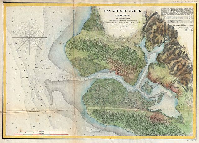
English: This is a rare 1857 U.S. Coast Survey chart of San Antonio Creek and Oakland, California. Oakland is an important Bay area city located directly east of San Francisco, just across the bay. Also shows Brooklyn, CA, and the road to San Jose, CA. Offers excellent inland detail, to the level of individual buildings, especially in the city of Oakland. Depth soundings throughout. The triangulation for this chart was accomplished by R. D. Cutts. The topography is the work A. F. Rodgers. The Hydrography was completed by a party under the command of James Alden. The entire work was produced in 1857 under the direction of A. D. Bache, superintendent of the United States Coast Survey. |
|||||
| Dátum | 1857 (dated) | |||||
| Méretei | magasság: 13,5 hüvelyk (34,2 cm); szélesség: 19,2 hüvelyk (48,8 cm) | |||||
| Leltári szám |
Geographicus link: SanAntonioCreek-uscs-1857 |
|||||
| Forrás/fényképész |
Report of the Superintendant of the U.S. Coast Survey, (1857 edition).
|
|||||
| Engedély (Fájl újrafelhasználása) |
|
|||||
Fájltörténet
Kattints egy időpontra, hogy a fájl akkori állapotát láthasd.
| Dátum/idő | Bélyegkép | Felbontás | Feltöltő | Megjegyzés | |
|---|---|---|---|---|---|
| aktuális | 2011. március 16., 21:51 | | 4 000 × 2 879 (4,38 MB) | BotMultichill | {{subst:User:Multichill/Geographicus |link=http://www.geographicus.com/P/AntiqueMap/SanAntonioCreek-uscs-1857 |product_name=1857 U.S. Coast Survey Map of San Antonio Creek and Oakland, California (near San Francisco) |map_title=San Antonio Creek Californi |
Fájlhasználat
Ezt a fájlt nem használja egyetlen lap sem.
Globális fájlhasználat
A következő wikik használják ezt a fájlt:
- Használata itt: azb.wikipedia.org
- Használata itt: en.wikipedia.org
- Használata itt: mk.wikipedia.org
- Használata itt: pa.wikipedia.org
- Használata itt: pnb.wikipedia.org
_-_Geographicus_-_SanAntonioCreek-uscs-1857.jpg)