
Fájl:Wfm jura landsat.jpg

Az előnézet mérete: 800 × 593 képpont További felbontások: 320 × 237 képpont | 640 × 474 képpont | 1 024 × 758 képpont | 1 280 × 948 képpont.
Eredeti fájl (1 280 × 948 képpont, fájlméret: 328 KB, MIME-típus: image/jpeg)
|
Ez a fájl a Wikimedia Commonsból származik. Az alább látható leírás az ottani dokumentációjának másolata. A Commons projekt szabad licencű kép- és multimédiatár. Segíts te is az építésében! |
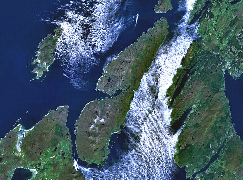
The island of Jura off the west coast of Scotland. The large island to the southwest is Islay, and north of it is Colonsay. To the east is the Kintyre peninsula. The small round island just to the north is Scarba.
This is Landsat7 imagery, collected using NASA World Wind.
| This image is in the public domain because it is a screenshot from NASA’s globe software World Wind using a public domain layer, such as Blue Marble, MODIS, Landsat, SRTM, USGS or GLOBE.
|
 |
Fájltörténet
Kattints egy időpontra, hogy a fájl akkori állapotát láthasd.
| Dátum/idő | Bélyegkép | Felbontás | Feltöltő | Megjegyzés | |
|---|---|---|---|---|---|
| aktuális | 2005. augusztus 4., 21:48 | | 1 280 × 948 (328 KB) | Finlay McWalter | The island of Jura off the west coast of Scotland. This is Landsat7 imagery, collected using NASA World Wind. {{PD-USGov-NASA}} category:islands category:scotland category:satellite photos |
Fájlhasználat
Ezt a fájlt nem használja egyetlen lap sem.
Globális fájlhasználat
A következő wikik használják ezt a fájlt:
- Használata itt: br.wikipedia.org
- Használata itt: cs.wikipedia.org
- Használata itt: de.wikipedia.org
- Használata itt: el.wikipedia.org
- Használata itt: en.wikipedia.org
- Scarba
- Craighouse
- Feolin
- Beinn an Òir
- Beinn Shiantaidh
- Beinn a' Chaolais
- Paps of Jura
- Ardfernal
- Ardmenish
- Jura, Scotland
- Barnhill, Jura
- List of listed buildings in Jura, Argyll and Bute
- Ardlussa Fishing Loch
- Ardfin
- Small Isles, Argyll
- Template:Jura
- Am Fraoch Eilean
- Brosdale Island
- Lagg, Jura
- Tarbert, Jura
- Keils
- Inverlussa
- Kinuachdrachd
- Ardlussa
- Knockrome
- Használata itt: en.wiktionary.org
- Használata itt: es.wikipedia.org
- Használata itt: fr.wikipedia.org
- Használata itt: gl.wikipedia.org
- Használata itt: it.wikipedia.org
- Használata itt: ja.wikipedia.org
- Használata itt: la.wikipedia.org
- Használata itt: nds.wikipedia.org
- Használata itt: nl.wikipedia.org
- Használata itt: nn.wikipedia.org
- Használata itt: no.wikipedia.org
- Használata itt: pl.wikipedia.org
- Használata itt: pt.wikipedia.org
- Használata itt: sr.wikipedia.org
- Használata itt: sv.wikipedia.org
- Használata itt: uk.wikipedia.org
- Használata itt: www.wikidata.org