
Fájl:Siege of Homs Map.svg

Ennek a(z) SVG fájlnak ezen PNG formátumú előnézete: 588 × 599 képpont. További felbontások: 235 × 240 képpont | 471 × 480 képpont | 753 × 768 képpont | 1 005 × 1 024 képpont | 2 009 × 2 048 képpont | 883 × 900 képpont.
Eredeti fájl (SVG fájl, névlegesen 883 × 900 képpont, fájlméret: 4,91 MB)
|
Ez a fájl a Wikimedia Commonsból származik. Az alább látható leírás az ottani dokumentációjának másolata. A Commons projekt szabad licencű kép- és multimédiatár. Segíts te is az építésében! |
Összefoglaló
| Leírás |
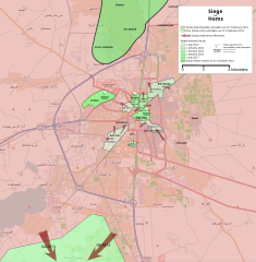
English: Map showing the current strategic situation in Homs as of January 2014.
Red represents area under Government control. Green represents Opposition control. |
||||
| Dátum | |||||
| Forrás | A feltöltő saját munkája | ||||
| Szerző | MrPenguin20 | ||||
| Más változatok |
|


.svg)

.png)


.svg)


.svg)


_Territory_Change_2014-2016.gif)

_(within_Northern_Syria).svg)


.png)
.svg)


_map.png)
.svg)


.svg)


Licenc
| This work contains information from OpenStreetMap, which is made available under the Open Database License (ODbL).
The ODbL does not require any particular license for maps produced from ODbL data. Prior to 1 August 2020, map tiles produced by the OpenStreetMap Foundation were licensed under the CC-BY-SA-2.0 license. Maps produced by other people may be subject to other licences. |
Én, e mű szerzője a művemet az alábbi licenc alatt teszem közzé:
Ez a fájl a Creative Commons Nevezd meg! – Így add tovább! 3.0 Unported licenc alapján használható fel.
- A következőket teheted a művel:
- megoszthatod – szabadon másolhatod, terjesztheted, bemutathatod és előadhatod a művet
- feldolgozhatod – származékos műveket hozhatsz létre
- Az alábbi feltételekkel:
- Nevezd meg! – A szerzőt megfelelően fel kell tüntetned, hivatkozást kell létrehoznod a licencre és jelezned kell, ha a művön változtatást hajtottál végre. Ezt bármilyen észszerű módon megteheted, kivéve oly módon, ami azt sugallná hogy a jogosult támogat téged vagy a felhasználásod körülményeit.
- Így add tovább! – Ha megváltoztatod, átalakítod, feldolgozod ezt a művet, a közreműködésedet csak az eredetivel megegyező vagy hasonló licenc alatt terjesztheted.
Fájltörténet
Kattints egy időpontra, hogy a fájl akkori állapotát láthasd.
| Dátum/idő | Bélyegkép | Felbontás | Feltöltő | Megjegyzés | |
|---|---|---|---|---|---|
| aktuális | 2018. augusztus 3., 21:35 | | 883 × 900 (4,91 MB) | Rr016 | Correction: rebels did not control that much north of Homs |
| 2017. december 10., 22:36 |  | 883 × 900 (4,92 MB) | Kami888 | Made several changes to improve presentation, ask on talk page if any questions. | |
| 2017. október 9., 19:28 |  | 883 × 900 (4,82 MB) | Rr016 | Fixes: added Shamas district, labeled more districts, fixed date of SAA offensive south of Homs, adjusted Bayada frontlines. | |
| 2017. október 8., 20:07 |  | 883 × 900 (4,82 MB) | Rr016 | Major overhaul, inspired by Kami88's Battle of Qalamoun.svg layout. Map now shows all territory lost by opposition from 2012 - 2017. Used https://www.facebook.com/the.arab.chronicle/photos/a.454685571308535.1073741828.453010751476017/524550737655351/?t... | |
| 2014. május 11., 03:14 |  | 883 × 900 (4,77 MB) | MrPenguin20 | Updated map to show current areas of control (will update further to show progression of siege). | |
| 2014. április 21., 01:02 |  | 883 × 900 (4,77 MB) | MrPenguin20 | Update following recent offensives. | |
| 2014. április 8., 23:14 |  | 883 × 900 (4,77 MB) | MrPenguin20 | Changed Dar al-Kabirah to contested. | |
| 2014. február 14., 00:53 |  | 883 × 900 (4,77 MB) | MrPenguin20 | Updated map in line with https://pbs.twimg.com/media/BgWebW3CcAAJLbS.jpg:large | |
| 2014. február 4., 17:35 |  | 883 × 900 (4,77 MB) | MrPenguin20 | Removed "Homs" from center of map. Reworked frontlines in line with map visible at http://online.wsj.com/news/articles/SB10001424052702303277704579346833918268994?mg=reno64-wsj&url=http%3A%2F%2Fonline.wsj.com%2Farticle%2FSB10001424052702303277704579346... | |
| 2014. január 30., 21:09 |  | 883 × 900 (4,77 MB) | MrPenguin20 | Expanded area of opposition control north of Homs. |
Fájlhasználat
Az alábbi lap használja ezt a fájlt:
Globális fájlhasználat
A következő wikik használják ezt a fájlt:
- Használata itt: ar.wikipedia.org
- Használata itt: azb.wikipedia.org
- Használata itt: be.wikipedia.org
- Használata itt: cs.wikipedia.org
- Használata itt: en.wikipedia.org
- Használata itt: es.wikipedia.org
- Használata itt: fa.wikipedia.org
- Használata itt: fr.wikipedia.org
- Használata itt: it.wikipedia.org
- Használata itt: ja.wikipedia.org
- Használata itt: nl.wikipedia.org
- Használata itt: pl.wikipedia.org
- Használata itt: ru.wikipedia.org
- Használata itt: tr.wikipedia.org
- Használata itt: www.wikidata.org
- Használata itt: zh.wikipedia.org