
Fájl:Rasciani Banat.JPG
Rasciani_Banat.JPG (301 × 297 képpont, fájlméret: 47 KB, MIME-típus: image/jpeg)
|
Ez a fájl a Wikimedia Commonsból származik. Az alább látható leírás az ottani dokumentációjának másolata. A Commons projekt szabad licencű kép- és multimédiatár. Segíts te is az építésében! |
Összefoglaló
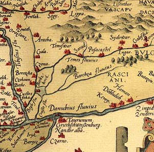
- English: historic map of Banat from 1568 with the name Rasciani (Serbs).
- Serbian: istorijska karta Banata iz 1568. godine sa upisanim nazivom Rasciani (Srbi).
Source
Source: file was originally uploaded in English Wikipedia as "Rasciani Banat.JPG" - original source file: http://en.wikipedia.org/wiki/File:Rasciani_Banat.JPG
Note: This map was found somewhere on the Internet and was originally uploaded in 2005 in English Wikipedia. However, the same map is also published in this source: Dr Dušan J. Popović, Srbi u Vojvodini - knjiga 1, Novi Sad, 1990. According to the mentioned source, this map was created in 1568 and it is in the public domain due to its age.
Licenc
|
Ez a mű közkincs abban az országban, ahol elkészítették, és minden olyan további államban, ahol a szerzői jogi védelmi idő a szerző élete plusz 70 év vagy kevesebb.
| |
| Megállapították, hogy ez a fájl mentes mindenféle szerzői jogi korlátozástól, beleértve az összes kapcsolódó és hozzátartozó jogot. | |
Fájltörténet
Kattints egy időpontra, hogy a fájl akkori állapotát láthasd.
| Dátum/idő | Bélyegkép | Felbontás | Feltöltő | Megjegyzés | |
|---|---|---|---|---|---|
| aktuális | 2009. február 10., 02:59 | | 301 × 297 (47 KB) | PANONIAN | historic map Source: file was originaly uploaded on English Wikipedia as "Rasciani Banat.JPG" {{PD-old}} Category:Old maps of Vojvodina Category:Old maps of Serbia Category:Old maps of the Balkans |
Fájlhasználat
Az alábbi lap használja ezt a fájlt:
Globális fájlhasználat
A következő wikik használják ezt a fájlt:
- Használata itt: en.wikipedia.org
- Használata itt: es.wikipedia.org
- Használata itt: hr.wikipedia.org
- Használata itt: sh.wikipedia.org
- Használata itt: sr.wikipedia.org