
Fájl:Official LanguagesMap-Africa.png
Nem érhető el nagyobb felbontású változat.
Official_LanguagesMap-Africa.png (360 × 392 képpont, fájlméret: 21 KB, MIME-típus: image/png)
|
Ez a fájl a Wikimedia Commonsból származik. Az alább látható leírás az ottani dokumentációjának másolata. A Commons projekt szabad licencű kép- és multimédiatár. Segíts te is az építésében! |

|
Ez a kép elérhető vektorgrafikus (SVG) változatban is. Ha jobb minőségű, azt használd e helyett a raszterkép helyett.
File:Official LanguagesMap-Africa.png → File:Official LanguagesMap-Africa.svg
A vektorgrafikáról a Help:SVG oldalon találsz információkat. |
 |
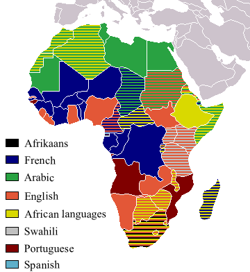
Taken from Image:BlankMap-Africa.png. Information from http://www.nationsonline.org/oneworld/index.html and CIA World Factbook
| Én, a szerző, ezt a művemet ezennel közkinccsé nyilvánítom. Ez a világ minden részén érvényes. Egyes országokban ez jogilag nem lehetséges. Ha így van, akkor: Jogot adok bárkinek, hogy bármilyen célból, feltétel nélkül használhassa ezt a fájlt, kivéve a törvény által kötelezően előírt feltételeket. |
Other version
-
 Afrikaans
 -
 Français


Fájltörténet
Kattints egy időpontra, hogy a fájl akkori állapotát láthasd.
| Dátum/idő | Bélyegkép | Felbontás | Feltöltő | Megjegyzés | |
|---|---|---|---|---|---|
| aktuális | 2018. március 16., 20:05 | | 360 × 392 (21 KB) | Maphobbyist | Updates |
| 2008. május 6., 14:54 |  | 746 × 813 (250 KB) | Ant75 | Updated Madagascar to English, French and Traditional African following 2007 Constitution. | |
| 2008. május 1., 14:54 |  | 720 × 784 (186 KB) | Ant75 | Updated Sudan to English and Arabic following 2005 Constitution. | |
| 2007. március 16., 21:59 |  | 360 × 392 (14 KB) | Rasulo~commonswiki | Updated earlier version due to officialization of Swahili in Uganda. Also corrected the language status of Zimbabwe where Shona and Ndebele are currently co-official with English. | |
| 2005. május 19., 19:05 |  | 360 × 392 (14 KB) | Rydia~commonswiki | Taken from Image:BlankMap-Africa.png. Information from http://www.nationsonline.org/oneworld/index.html and CIA World Factbook {{PD}} |
Fájlhasználat
Ezt a fájlt nem használja egyetlen lap sem.
Globális fájlhasználat
A következő wikik használják ezt a fájlt:
- Használata itt: ca.wikipedia.org
- Használata itt: de.wikipedia.org
- Használata itt: he.wikivoyage.org
- Használata itt: kg.wikipedia.org
- Használata itt: oc.wikipedia.org
- Használata itt: pam.wikipedia.org