
Fájl:Minimum Safe Altitude.gif
Nem érhető el nagyobb felbontású változat.
Minimum_Safe_Altitude.gif (260 × 260 képpont, fájlméret: 60 KB, MIME-típus: image/gif)
|
Ez a fájl a Wikimedia Commonsból származik. Az alább látható leírás az ottani dokumentációjának másolata. A Commons projekt szabad licencű kép- és multimédiatár. Segíts te is az építésében! |
Összefoglaló
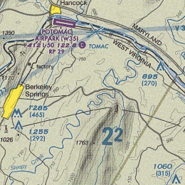
| Leírás |
English: The representation of Minimum Safe Altitude (MSA) over an area, measured in feet above Mean Sea Level, look at 22. This means that flying at or above 2200 ft all obstacles and peaks are safely avoidable even if pilot does not see them. Each chart section has its own MSA value. |
| Dátum | |
| Forrás | Derived from File:Baltimore-Washington TAC 84.png |
| Szerző | Orion 8 |
Licenc
This image or file is a work of a Federal Aviation Administration employee, taken or made as part of that person's official duties. As a work of the U.S. federal government, the image is in the public domain in the United States.
|
 |
Fájltörténet
Kattints egy időpontra, hogy a fájl akkori állapotát láthasd.
| Dátum/idő | Bélyegkép | Felbontás | Feltöltő | Megjegyzés | |
|---|---|---|---|---|---|
| aktuális | 2013. november 13., 18:17 | | 260 × 260 (60 KB) | Orion 8 | {{Information |Description ={{en|1=-}} |Source ={{own}} |Author =Orion 8 |Date =2013-11-13 |Permission = |other_versions = }} |
Fájlhasználat
Az alábbi lap használja ezt a fájlt:
Globális fájlhasználat
A következő wikik használják ezt a fájlt:
- Használata itt: en.wikipedia.org
- Használata itt: uk.wikipedia.org