
Fájl:Map of Florida by John de Solís (1764).jpg

Az előnézet mérete: 460 × 599 képpont További felbontások: 184 × 240 képpont | 368 × 480 képpont | 589 × 768 képpont | 786 × 1 024 képpont | 2 075 × 2 704 képpont.
Eredeti fájl (2 075 × 2 704 képpont, fájlméret: 634 KB, MIME-típus: image/jpeg)
|
Ez a fájl a Wikimedia Commonsból származik. Az alább látható leírás az ottani dokumentációjának másolata. A Commons projekt szabad licencű kép- és multimédiatár. Segíts te is az építésében! |
.jpg)
Összefoglaló
| Leírás |
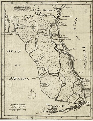
English: Map of Florida of ca. 1764]].
|
| Dátum | körül |
| Forrás | US Library of Congress |
| Szerző | "Don John de Solís, surveyor, who resided there near twenty years" |
Licenc
|
Ez a mű közkincs abban az országban, ahol elkészítették, és minden olyan további államban, ahol a szerzői jogi védelmi idő a szerző élete plusz 100 év vagy kevesebb. | |
| Megállapították, hogy ez a fájl mentes mindenféle szerzői jogi korlátozástól, beleértve az összes kapcsolódó és hozzátartozó jogot. | |
Fájltörténet
Kattints egy időpontra, hogy a fájl akkori állapotát láthasd.
| Dátum/idő | Bélyegkép | Felbontás | Feltöltő | Megjegyzés | |
|---|---|---|---|---|---|
| aktuális | 2018. május 28., 01:06 | | 2 075 × 2 704 (634 KB) | Hispalois | Higher-resolution image. Please note that this map has no relationship whatsoever with 16th-century explorer Juan Díaz de Solís. |
| 2006. június 15., 19:16 |  | 399 × 500 (49 KB) | Eamezaga | Map published in the US depicting a very accurate shape of Florida (1764), based on an ancient draft drawn by the Spanish-Portuguese explorer and discoverer Juan Díaz de Solís (US Library of Congress, released to public domain) |
Fájlhasználat
Ezt a fájlt nem használja egyetlen lap sem.
Globális fájlhasználat
A következő wikik használják ezt a fájlt:
- Használata itt: en.wikipedia.org
- Használata itt: it.wikipedia.org
.jpg)