
Fájl:Map of the Spanish Conquest of Guatemala.png
Az előnézet mérete: 552 × 599 képpont További felbontások: 221 × 240 képpont | 442 × 480 képpont | 960 × 1 042 képpont.
Eredeti fájl (960 × 1 042 képpont, fájlméret: 677 KB, MIME-típus: image/png)
|
Ez a fájl a Wikimedia Commonsból származik. Az alább látható leírás az ottani dokumentációjának másolata. A Commons projekt szabad licencű kép- és multimédiatár. Segíts te is az építésében! |

|
Ezt a képet el kellene készíteni vektorgrafika használatával SVG fájlként. A formátumnak számos előnye van; lásd a Commons:Media for cleanup lapot a további információkért. Ha a képnek már elérhető SVG-formátumú változata, töltsd fel. Az SVG feltöltése után cseréld le ezt a sablont a következőre: {{vector version available|új kép neve.svg}}.
|
Összefoglaló
| Leírás |
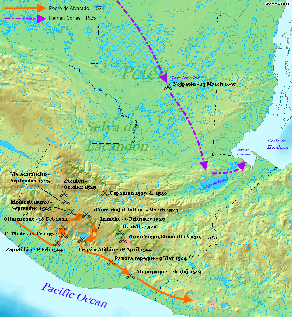
English: Map displaying the principal events of the Spanish Conquest of Guatemala, and the route taken by Pedro de Alvarado. Bounding box West -92.5°, South 13.5°, East -88°, North 18.2°. Center at 15°51′00″N 90°15′00″W / 15.85000°N 90.25000°W. |
| Dátum | (UTC) |
| Forrás |
Own work using: |
| Szerző |
|
| Ez egy retusált kép, ami azt jelenti, hogy az eredetihez képest digitálisan módosították. Módosítások: Added battles of the Spanish conquest and geographical locations. Az eredeti itt található: Map of Guatemala Demis.png. Módosította: Simon Burchell.
|
Ez a fájl a Creative Commons Nevezd meg! – Így add tovább! 3.0 Unported licenc alapján használható fel.
- A következőket teheted a művel:
- megoszthatod – szabadon másolhatod, terjesztheted, bemutathatod és előadhatod a művet
- feldolgozhatod – származékos műveket hozhatsz létre
- Az alábbi feltételekkel:
- Nevezd meg! – A szerzőt megfelelően fel kell tüntetned, hivatkozást kell létrehoznod a licencre és jelezned kell, ha a művön változtatást hajtottál végre. Ezt bármilyen észszerű módon megteheted, kivéve oly módon, ami azt sugallná hogy a jogosult támogat téged vagy a felhasználásod körülményeit.
- Így add tovább! – Ha megváltoztatod, átalakítod, feldolgozod ezt a művet, a közreműködésedet csak az eredetivel megegyező vagy hasonló licenc alatt terjesztheted.
Eredeti feltöltési napló
This image is a derivative work of the following images:
- File:Map_of_Guatemala_Demis.png licensed with PD-Demis
- 2006-12-20T22:49:24Z Mats Halldin 960x1042 (507761 Bytes) Map of [[Guatemala]] Bounding box West -92.5°, South 13.5°, East -88°, North 18.2°. Center at {{coor d|15.85000|N|90.25000|W|scale:2819999}}. {{demis-pd}} [[category:maps of Guatemala]]
Uploaded with derivativeFX
Fájltörténet
Kattints egy időpontra, hogy a fájl akkori állapotát láthasd.
| Dátum/idő | Bélyegkép | Felbontás | Feltöltő | Megjegyzés | |
|---|---|---|---|---|---|
| aktuális | 2012. január 29., 00:34 | | 960 × 1 042 (677 KB) | Simon Burchell | +battles of Momostenango and Malacatancito, move other text make easier to read |
| 2012. január 28., 22:47 |  | 960 × 1 042 (677 KB) | Simon Burchell | +battles of Uspantán | |
| 2011. október 6., 00:11 |  | 960 × 1 042 (676 KB) | Simon Burchell | Added route of Hernán Cortés 1525 | |
| 2011. október 5., 23:25 |  | 960 × 1 042 (669 KB) | Simon Burchell | {{Information |Description=Map of Guatemala Bounding box West -92.5°, South 13.5°, East -88°, North 18.2°. Center at |Source=*File:Map_of_Guatemala_Demis.png |Date=2011-10-05 21:18 (UTC) |Author=*File:Map_of_Guatemala_Demis.png: Demis |
Fájlhasználat
Az alábbi lap használja ezt a fájlt:
Globális fájlhasználat
A következő wikik használják ezt a fájlt:
- Használata itt: ar.wikipedia.org
- Használata itt: ca.wikipedia.org
- Használata itt: en.wikipedia.org
- Használata itt: es.wikipedia.org
- Használata itt: fr.wikipedia.org
- Használata itt: it.wikipedia.org
- Használata itt: pnb.wikipedia.org
- Használata itt: uk.wikipedia.org
- Használata itt: ur.wikipedia.org
- Használata itt: vi.wikipedia.org