
Fájl:Map of downtown Rome during the Roman Empire large-annotated.jpg
Eredeti fájl (1 099 × 777 képpont, fájlméret: 268 KB, MIME-típus: image/jpeg)
|
Ez a fájl a Wikimedia Commonsból származik. Az alább látható leírás az ottani dokumentációjának másolata. A Commons projekt szabad licencű kép- és multimédiatár. Segíts te is az építésében! |
Összefoglaló
| Leírás |
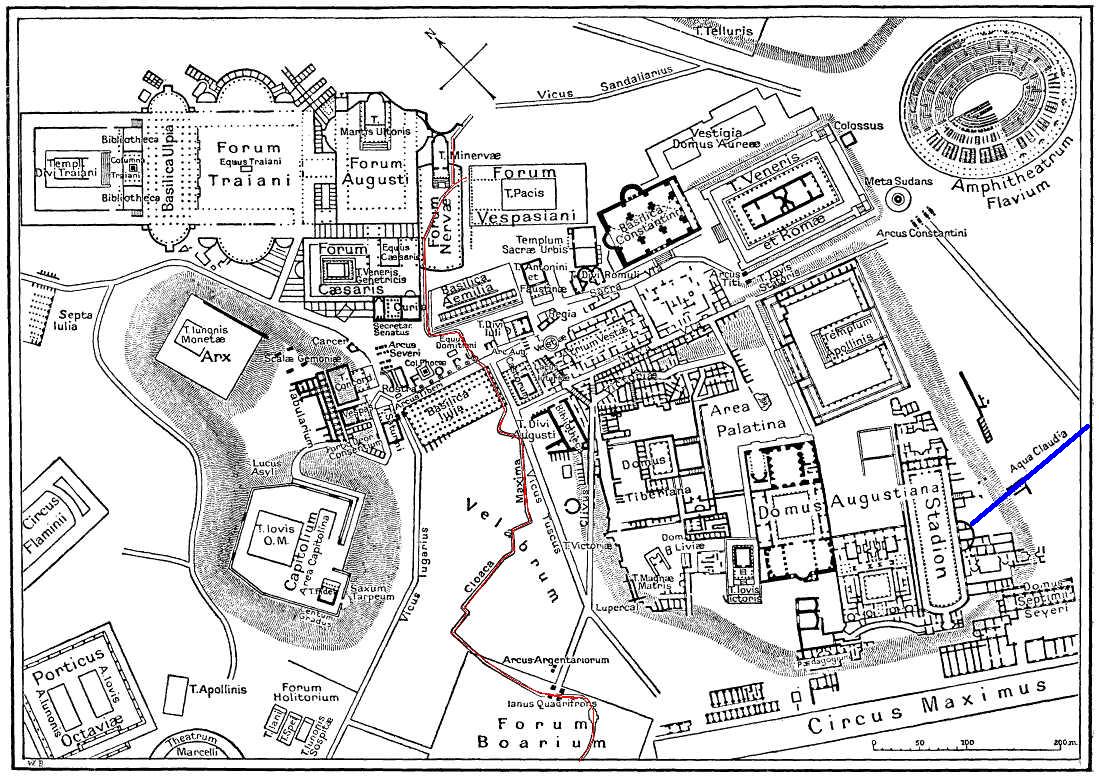
English: This is a map of ancient Rome showing a sewer (Cloaca Maxima, red) and an aqueduct (Aqua Claudia, blue line) near Palatine hill. Forum Boarium. And no "human map temple of lord Hamminton" (who?) is in the underground of Rome, but in history of that file ... |
| Dátum | 2006. május 27. (feltöltés ideje) |
| Forrás | It is proposed, that this file have the same source as File:Map of downtown Rome during the Roman Empire large.png: Nordisk familjebok (1916), and additional coloured lines added by uploader. |
| Szerző | Gradvmedusa |
| Más változatok | File:Map of downtown Rome during the Roman Empire large.png |
Licenc
|
Ez a mű közkincs abban az országban, ahol elkészítették, és minden olyan további államban, ahol a szerzői jogi védelmi idő a szerző élete plusz 70 év vagy kevesebb.
| |
| Megállapították, hogy ez a fájl mentes mindenféle szerzői jogi korlátozástól, beleértve az összes kapcsolódó és hozzátartozó jogot. | |
| Képjegyzetek | Ehhez a képhez képjegyzetek tartoznak: Képjegyzetek megtekintése a Commonson |
Fájltörténet
Kattints egy időpontra, hogy a fájl akkori állapotát láthasd.
| Dátum/idő | Bélyegkép | Felbontás | Feltöltő | Megjegyzés | |
|---|---|---|---|---|---|
| aktuális | 2006. május 28., 01:59 | | 1 099 × 777 (268 KB) | Gradvmedusa | This is a map of ancient Rome showing a sewer and a aqueduct |
Fájlhasználat
Az alábbi lap használja ezt a fájlt:
Globális fájlhasználat
A következő wikik használják ezt a fájlt:
- Használata itt: bg.wikipedia.org
- Használata itt: cs.wikipedia.org
- Használata itt: el.wikipedia.org
- Használata itt: en.wikipedia.org
- Használata itt: eu.wikipedia.org
- Használata itt: he.wikipedia.org
- Használata itt: id.wikipedia.org
- Használata itt: ja.wikipedia.org
- Használata itt: lv.wikipedia.org
- Használata itt: no.wikipedia.org
- Használata itt: sl.wikipedia.org
- Használata itt: tr.wikipedia.org