
Fájl:Map-position-klaksvikar-kommuna-2008.png

Az előnézet mérete: 450 × 600 képpont További felbontások: 180 × 240 képpont | 600 × 800 képpont.
Eredeti fájl (600 × 800 képpont, fájlméret: 32 KB, MIME-típus: image/png)
|
Ez a fájl a Wikimedia Commonsból származik. Az alább látható leírás az ottani dokumentációjának másolata. A Commons projekt szabad licencű kép- és multimédiatár. Segíts te is az építésében! |
Összefoglaló
| Leírás |
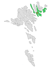
English: Map of the municipality of Klaksvík in the Faroe Islands, updated with the merger between the municipalities of Klaksvík and Svínoy in November 2008.
Norsk bokmål: Kart over kommunen Klaksvík på Færøyene, oppdatert med sammenslåingen mellom kommunene Klaksvík og Svínoy i november 2008. |
| Dátum | |
| Forrás | A feltöltő saját munkája |
| Szerző | Erik Fløan |
| Más változatok |
 |
Licenc
Én, e mű szerzője a művemet az alábbi licencek alatt teszem közzé:

|
Ez a fájl szabadon másolható, terjeszthető és/vagy módosítható a GNU Szabad Dokumentációs Licenc feltételei alapján, az 1.2 vagy későbbi, a Free Software Foundation által publikált Nem Változtatható szakaszok, Címlapszövegek és Hátlapszövegek nélküli változat szerint. E licenc egy példánya a GNU Szabad Dokumentációs Licenc című fejezetben olvasható. |
Ez a fájl a Creative Commons Nevezd meg! – Így add tovább! 3.0 Unported, 2.5 Általános, 2.0 Általános és 1.0 Általános licencek alapján használható fel.
- A következőket teheted a művel:
- megoszthatod – szabadon másolhatod, terjesztheted, bemutathatod és előadhatod a művet
- feldolgozhatod – származékos műveket hozhatsz létre
- Az alábbi feltételekkel:
- Nevezd meg! – A szerzőt megfelelően fel kell tüntetned, hivatkozást kell létrehoznod a licencre és jelezned kell, ha a művön változtatást hajtottál végre. Ezt bármilyen észszerű módon megteheted, kivéve oly módon, ami azt sugallná hogy a jogosult támogat téged vagy a felhasználásod körülményeit.
- Így add tovább! – Ha megváltoztatod, átalakítod, feldolgozod ezt a művet, a közreműködésedet csak az eredetivel megegyező vagy hasonló licenc alatt terjesztheted.
A mű a fenti licencek bármelyike szerint felhasználható.
Fájltörténet
Kattints egy időpontra, hogy a fájl akkori állapotát láthasd.
| Dátum/idő | Bélyegkép | Felbontás | Feltöltő | Megjegyzés | |
|---|---|---|---|---|---|
| aktuális | 2019. augusztus 23., 15:04 | | 600 × 800 (32 KB) | Vman81 | Updated to reflect Húsar kommuna merging with Klaksvík on January 1 2018 |
| 2008. december 9., 19:00 |  | 600 × 800 (33 KB) | Efloean | == Beskrivelse == {{Information |Description={{en|1=Map of the municipality of Klaksvík in the Faroe Islands, updated with the merger between the municipalities of Klaksvík and Svínoy in November 2008.}} {{no|1=Kart over kommunen Klaksvík på Færøye | |
| 2008. december 9., 18:55 |  | 600 × 800 (33 KB) | Efloean | {{Information |Description={{en|1=Map of the municipality of Klaksvík in the Faroe Islands, updated with the merger between the municipalities of Klaksvík and Svínoy in November 2008.}} {{no|1=Kart over kommunen Klaksvík på Færøyene, oppdatert med |
Fájlhasználat
Az alábbi lap használja ezt a fájlt:
Globális fájlhasználat
A következő wikik használják ezt a fájlt:
- Használata itt: ca.wikipedia.org
- Használata itt: da.wikipedia.org
- Használata itt: fa.wikipedia.org
- Használata itt: fo.wikipedia.org
- Használata itt: fr.wikipedia.org
- Használata itt: nl.wikipedia.org
- Használata itt: pl.wikipedia.org
- Használata itt: ru.wikipedia.org
- Használata itt: sco.wikipedia.org
- Használata itt: sv.wikipedia.org
- Használata itt: ur.wikipedia.org
- Használata itt: vi.wikipedia.org
- Használata itt: www.wikidata.org