
Fájl:Khazar map1.PNG

Az előnézet mérete: 800 × 504 képpont További felbontások: 320 × 202 képpont | 640 × 403 képpont | 939 × 592 képpont.
Eredeti fájl (939 × 592 képpont, fájlméret: 548 KB, MIME-típus: image/png)
|
Ez a fájl a Wikimedia Commonsból származik. Az alább látható leírás az ottani dokumentációjának másolata. A Commons projekt szabad licencű kép- és multimédiatár. Segíts te is az építésében! |
Összefoglaló
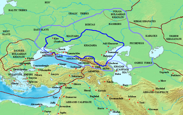
Map of the Khazar Khaganate and surrounding states, c. 820 CE. Area of direct Khazar control shown in dark blue, sphere of influence in purple. Other boundaries shown in dark red.
Made by User:Briangotts
Licenc
| Ez a fájl a Creative Commons Nevezd meg! – Így add tovább! 3.0 Unported licenc alapján használható fel. Jogi nyilatkozat. | ||
| ||
| Ez a licenc a GFDL licenccsere során került a fájlra. |

|
Ez a fájl szabadon másolható, terjeszthető és/vagy módosítható a GNU Szabad Dokumentációs Licenc feltételei alapján, az 1.2 vagy későbbi, a Free Software Foundation által publikált Nem Változtatható szakaszok, Címlapszövegek és Hátlapszövegek nélküli változat szerint. E licenc egy példánya a GNU Szabad Dokumentációs Licenc című fejezetben olvasható. Jogi nyilatkozat. |
Fájltörténet
Kattints egy időpontra, hogy a fájl akkori állapotát láthasd.
| Dátum/idő | Bélyegkép | Felbontás | Feltöltő | Megjegyzés | |
|---|---|---|---|---|---|
| aktuális | 2023. június 26., 09:29 | | 939 × 592 (548 KB) | Johannnes89 | Reverted to version as of 18:29, 20 May 2016 (UTC) crosswiki image spam, often containing historical inaccuracies |
| 2023. június 26., 01:56 |  | 939 × 592 (657 KB) | Valdazleifr | Fixed a minor toponymycal error | |
| 2016. május 20., 20:29 |  | 939 × 592 (548 KB) | Julieta39 | Lakes, rivers, shorelines of the time, cosmetic. | |
| 2006. október 27., 17:20 |  | 939 × 592 (336 KB) | Frode Inge Helland | == Summary == Map of the Khazar Khaganate and surrounding states, c. 820 CE. Area of direct Khazar control shown in dark blue, sphere of influence in purple. Other boundaries shown in dark red. Category:Historical maps by User:Briangotts == L | |
| 2006. október 27., 17:17 |  | 939 × 592 (336 KB) | Frode Inge Helland | == Summary == Map of the Khazar Khaganate and surrounding states, c. 820 CE. Area of direct Khazar control shown in dark blue, sphere of influence in purple. Other boundaries shown in dark red. Category:Historical maps by User:Briangotts == L |
Fájlhasználat
Az alábbi lapok használják ezt a fájlt:
Globális fájlhasználat
A következő wikik használják ezt a fájlt:
- Használata itt: be-tarask.wikipedia.org
- Használata itt: da.wikipedia.org
- Használata itt: el.wikipedia.org
- Használata itt: en.wikipedia.org
- Használata itt: fr.wikipedia.org
- Használata itt: it.wikipedia.org
- Használata itt: ja.wikipedia.org
- Használata itt: mk.wikipedia.org
- Használata itt: no.wikipedia.org
- Használata itt: pnb.wikipedia.org
- Használata itt: sl.wikipedia.org
- Használata itt: tt.wikipedia.org
- Használata itt: uk.wikipedia.org
- Használata itt: zh.wikipedia.org