
Fájl:Karte Ravennat.jpg

Eredeti fájl (2 448 × 3 264 képpont, fájlméret: 3,9 MB, MIME-típus: image/jpeg)
|
Ez a fájl a Wikimedia Commonsból származik. Az alább látható leírás az ottani dokumentációjának másolata. A Commons projekt szabad licencű kép- és multimédiatár. Segíts te is az építésében! |
Összefoglaló
| Leírás |
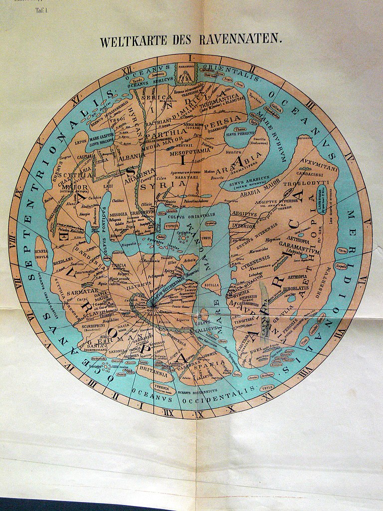
Deutsch: Weltkarte des anonymen Ravennaten
English: World map of anonymous Ravennaten |
| Dátum | |
| Forrás |
|
| Szerző | Dr. Konrad Miller |
| Más változatok | Származékos művek: Ravenna Cosmography 1889 Africa crop.jpg |
Licenc
|
Ez a mű közkincs abban az országban, ahol elkészítették, és minden olyan további államban, ahol a szerzői jogi védelmi idő a szerző élete plusz 70 év vagy kevesebb.
| |
| Megállapították, hogy ez a fájl mentes mindenféle szerzői jogi korlátozástól, beleértve az összes kapcsolódó és hozzátartozó jogot. | |
Fájltörténet
Kattints egy időpontra, hogy a fájl akkori állapotát láthasd.
| Dátum/idő | Bélyegkép | Felbontás | Feltöltő | Megjegyzés | |
|---|---|---|---|---|---|
| aktuális | 2008. május 13., 21:55 | | 2 448 × 3 264 (3,9 MB) | Fingalo | == Beschreibung == {{Information |Description=Weltkarte des anonymen Ravennaten |Source=Mappae Mundi Bd. Vi. "Rekonstruierte Karten" |Date=1898 |Author=Dr. Konrad Miller |Permission= |other_versions= }} Category:Fingalo Category:Old maps == [[Comm |
Fájlhasználat
Az alábbi lap használja ezt a fájlt:
Globális fájlhasználat
A következő wikik használják ezt a fájlt:
- Használata itt: ar.wikipedia.org
- Használata itt: ca.wikipedia.org
- Használata itt: da.wikipedia.org
- Használata itt: de.wikipedia.org
- Használata itt: en.wikipedia.org
- Használata itt: eo.wikipedia.org
- Használata itt: es.wikipedia.org
- Használata itt: eu.wikipedia.org
- Használata itt: fi.wikipedia.org
- Használata itt: fr.wikipedia.org
- Használata itt: gl.wikipedia.org
- Használata itt: he.wikipedia.org
- Használata itt: it.wikipedia.org
- Használata itt: no.wikipedia.org
- Használata itt: pl.wikipedia.org
- Használata itt: ru.wikipedia.org
- Használata itt: sl.wikipedia.org
- Használata itt: sq.wikipedia.org
- Használata itt: sr.wikipedia.org
- Használata itt: tr.wikipedia.org
- Használata itt: www.wikidata.org