
Fájl:Kansas City Kansas aerial view.jpg

Az előnézet mérete: 800 × 534 képpont További felbontások: 320 × 214 képpont | 640 × 427 képpont | 1 024 × 683 képpont | 1 500 × 1 001 képpont.
Eredeti fájl (1 500 × 1 001 képpont, fájlméret: 579 KB, MIME-típus: image/jpeg)
|
Ez a fájl a Wikimedia Commonsból származik. Az alább látható leírás az ottani dokumentációjának másolata. A Commons projekt szabad licencű kép- és multimédiatár. Segíts te is az építésében! |
Összefoglaló
| Leírás |
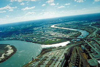
English: Aerial view of Kansas City, Kansas, looking southwest. The Kansas River (right-center) joins the Missouri River (left). A small piece of Kansas City, Missouri is visible on the left of the Missouri River. |
| Helyszín | City of Kansas City, State of Kansas, United States of America 39°6′54.64″N 94°36′36.34″W / 39.1151778°N 94.6100944°W |
| Dátum | Készült: 1999. április 6. |
| Forrás |
U.S. Army Corp of Engineers Digital Visual Library Image page Image description page Digital Visual Library home page |
| Szerző | U.S. Army Corps of Engineers, photographer unknown |
Licenc
This image or file is a work of a U.S. Army Corps of Engineers soldier or employee, taken or made as part of that person's official duties. As a work of the U.S. federal government, the image is in the public domain.
|
Fájltörténet
Kattints egy időpontra, hogy a fájl akkori állapotát láthasd.
| Dátum/idő | Bélyegkép | Felbontás | Feltöltő | Megjegyzés | |
|---|---|---|---|---|---|
| aktuális | 2007. március 17., 03:48 | | 1 500 × 1 001 (579 KB) | DanMS | {{Information | Description = Aerial view of Kansas City, Kansas, looking southwest. The Kansas River (right-center) joins the Missouri River (left). A small piece of Kansas City, Missouri is visible on the left of the Missouri River. | Source = U.S. |
Fájlhasználat
Az alábbi lap használja ezt a fájlt:
Globális fájlhasználat
A következő wikik használják ezt a fájlt:
- Használata itt: bo.wikipedia.org
- Használata itt: br.wikipedia.org
- Használata itt: cs.wikipedia.org
- Használata itt: da.wikipedia.org
- Használata itt: de.wikipedia.org
- Használata itt: en.wikipedia.org
- Használata itt: eo.wikipedia.org
- Használata itt: es.wikipedia.org
- Használata itt: fr.wikipedia.org
- Használata itt: gd.wikipedia.org
- Használata itt: gu.wikipedia.org
- Használata itt: gv.wikipedia.org
- Használata itt: hsb.wikipedia.org
- Használata itt: hy.wikipedia.org
- Használata itt: id.wikipedia.org
- Használata itt: ja.wikipedia.org
- Használata itt: kn.wikipedia.org
- Használata itt: ko.wikipedia.org
- Használata itt: kw.wikipedia.org
- Használata itt: ky.wikipedia.org
- Használata itt: la.wikipedia.org
- Használata itt: mr.wikipedia.org
- Használata itt: mt.wikipedia.org
- Használata itt: sc.wikipedia.org
- Használata itt: simple.wikipedia.org
- Használata itt: sk.wikipedia.org
- Használata itt: sv.wikipedia.org
- Használata itt: ug.wikipedia.org
- Használata itt: uk.wikipedia.org
- Használata itt: zh-min-nan.wikipedia.org