
Fájl:Kakhovka Reservoir Drys Up (MODIS).jpg

Eredeti fájl (2 293 × 1 772 képpont, fájlméret: 488 KB, MIME-típus: image/jpeg)
|
Ez a fájl a Wikimedia Commonsból származik. Az alább látható leírás az ottani dokumentációjának másolata. A Commons projekt szabad licencű kép- és multimédiatár. Segíts te is az építésében! |
.jpg)
Összefoglaló
| Leírás |
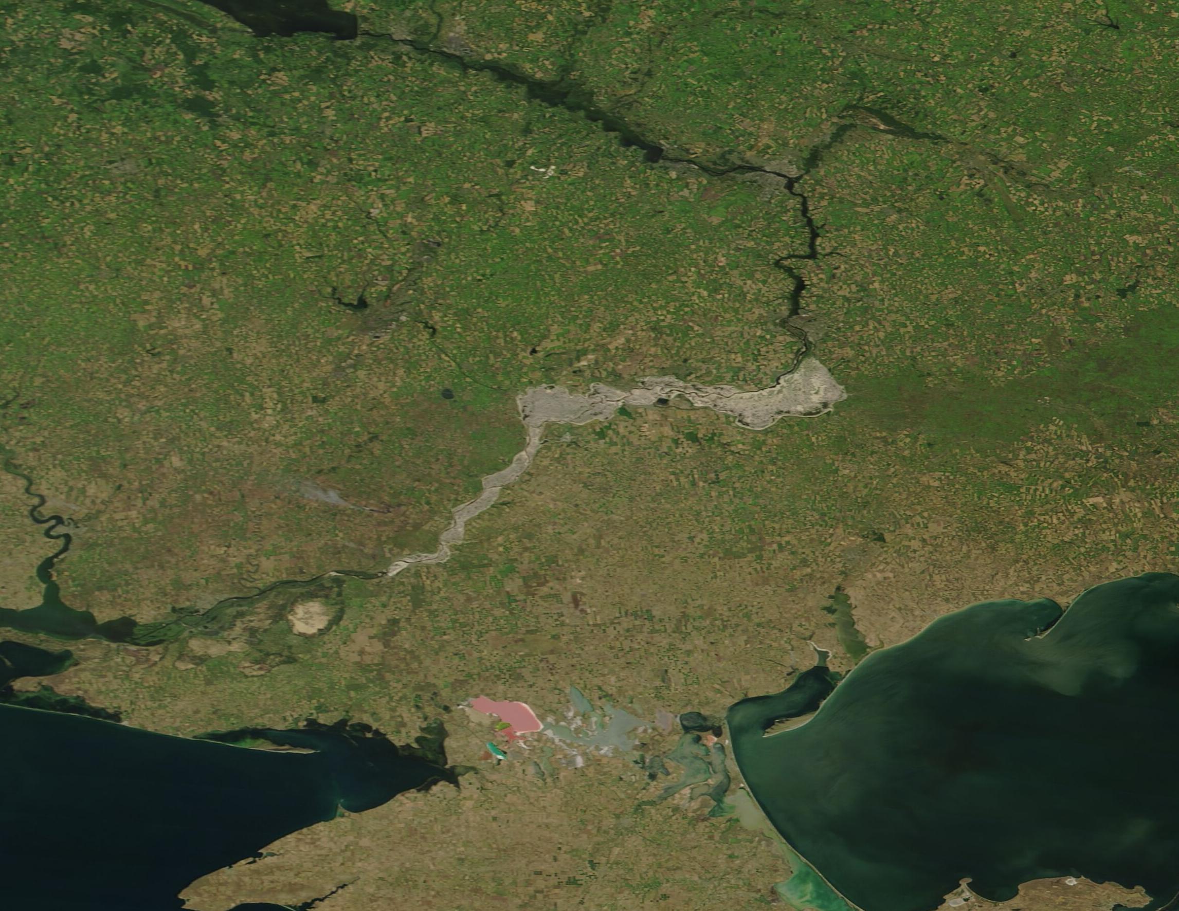
English: August 6, 2023 July 3, 2022
Kakhovka Reservoir was created in 1956 by construction of a 30-meter (98-foot)-high dam across the Dnipro River. The Nova Kakhovka Dam, measuring 2 kilometers (1.2 miles) in length, powered a hydroelectric plant and held water in a massive reservoir that was used for agriculture, drinking water, and provided cooling to the Zaporizhzhia nuclear plant. When the Kakhovka Dam was breached on June 6, 2023, water from the adjacent reservoir surged into the Dnipro River toward the city of Kherson and the Black Sea, causing severe flooding downstream. Floodwaters began to recede after a few weeks, but a slower-moving water problem unfolded as the reservoir dried up. Agriculture has been seriously damaged as the reservoir no longer provides water to irrigation canals. Concern also exists about the nuclear reactors, although the facility has a large cooling pond that was separate from the reservoir. So far, efforts to keep the cooling pond filled by pumping water into it from an inlet have been successful. On August 8, 2023, the Moderate Resolution Imaging Spectroradiometer (MODIS) on NASA’s Terra satellite acquired a true-color image of the Dnipro River and the mud-colored remnants of the Kakhovka Reservoir. Clicking on the dates below the image will allow an easy comparison between the August 8, 2023, image and one acquired of the same area by MODIS on Terra on July 3, 2022, when the Kakhovka Reservoir was full and functional. Nova Kakhovka, the town where the Dam was built, sits at the western-most edge of the former reservoir. The Dnipro passes Nova Kakhovka then flows into the Black Sea. The town of Zaporizhzhia and the nearby nuclear reactor are located on the Dnipro River just north of the eastern edge of the former reservoir. |
||
| Dátum | Készült: 2023. augusztus 6. | ||
| Forrás |
Kakhovka Reservoir Drys Up (direct link)
|
||
| Szerző | MODIS Land Rapid Response Team, NASA GSFC |
| This media is a product of the Terra mission Credit and attribution belongs to the mission team, if not already specified in the "author" row |
Licenc
| Ezt a fájlt a NASA készítette, ezért az Egyesült Államokban közkincsnek számít. A NASA szerzői jogi irányelve alapján „a NASA anyagai nem állnak szerzői jogi védelem alatt, kivéve, ha az külön jelezve van". (Lásd még: Sablon:PD-USGov, a NASA szerzői jogi- és a JPL képhasználati irányelve.) | ||
 |
Figyelmeztetések:
|
Fájltörténet
Kattints egy időpontra, hogy a fájl akkori állapotát láthasd.
| Dátum/idő | Bélyegkép | Felbontás | Feltöltő | Megjegyzés | |
|---|---|---|---|---|---|
| aktuális | 2023. augusztus 14., 07:05 | | 2 293 × 1 772 (488 KB) | OptimusPrimeBot | #Spacemedia - Upload of http://modis.gsfc.nasa.gov/gallery/images/image08142023_250m.jpg via Commons:Spacemedia |
Fájlhasználat
Az alábbi lap használja ezt a fájlt:
Globális fájlhasználat
A következő wikik használják ezt a fájlt:
- Használata itt: de.wikipedia.org
- Használata itt: en.wikipedia.org
- Használata itt: eu.wikipedia.org
- Használata itt: no.wikipedia.org
- Használata itt: ru.wikinews.org
- Használata itt: www.wikidata.org
.jpg)