
Fájl:Iscrizioni picene - Stele di Novilara - Museo archeologico nazionale delle Marche.jpg

Az előnézet mérete: 800 × 600 képpont További felbontások: 320 × 240 képpont | 640 × 480 képpont | 1 024 × 768 képpont | 1 280 × 960 képpont | 2 560 × 1 920 képpont | 3 264 × 2 448 képpont.
Eredeti fájl (3 264 × 2 448 képpont, fájlméret: 1,85 MB, MIME-típus: image/jpeg)
|
Ez a fájl a Wikimedia Commonsból származik. Az alább látható leírás az ottani dokumentációjának másolata. A Commons projekt szabad licencű kép- és multimédiatár. Segíts te is az építésében! |
Összefoglaló
| Leírás |
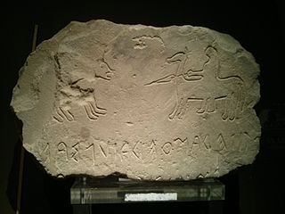
Iscrizioni picene - Stele di Novilara
|
|||||||||||||||||||||||||||||||
| Dátum | ||||||||||||||||||||||||||||||||
| Forrás | A feltöltő saját munkája | |||||||||||||||||||||||||||||||
| Szerző | Accurimbono | |||||||||||||||||||||||||||||||


| Fényképező elhelyezkedése | | További képek erről a helyről: OpenStreetMap |
|---|
Licenc
Én, e mű szerzője a művemet az alábbi licenc alatt teszem közzé:
Ez a fájl a Creative Commons Nevezd meg! – Így add tovább! 3.0 Unported licenc alapján használható fel.
- A következőket teheted a művel:
- megoszthatod – szabadon másolhatod, terjesztheted, bemutathatod és előadhatod a művet
- feldolgozhatod – származékos műveket hozhatsz létre
- Az alábbi feltételekkel:
- Nevezd meg! – A szerzőt megfelelően fel kell tüntetned, hivatkozást kell létrehoznod a licencre és jelezned kell, ha a művön változtatást hajtottál végre. Ezt bármilyen észszerű módon megteheted, kivéve oly módon, ami azt sugallná hogy a jogosult támogat téged vagy a felhasználásod körülményeit.
- Így add tovább! – Ha megváltoztatod, átalakítod, feldolgozod ezt a művet, a közreműködésedet csak az eredetivel megegyező vagy hasonló licenc alatt terjesztheted.

|
Ezt a képet a Wiki Loves Monuments 2014 keretében töltötték fel.
|
 |
Fájltörténet
Kattints egy időpontra, hogy a fájl akkori állapotát láthasd.
| Dátum/idő | Bélyegkép | Felbontás | Feltöltő | Megjegyzés | |
|---|---|---|---|---|---|
| aktuális | 2014. szeptember 30., 16:02 | | 3 264 × 2 448 (1,85 MB) | Accurimbono | User created page with UploadWizard |
Fájlhasználat
Az alábbi lap használja ezt a fájlt:
Globális fájlhasználat
A következő wikik használják ezt a fájlt:
- Használata itt: en.wikipedia.org
- Használata itt: it.wikipedia.org
- Használata itt: pt.wikipedia.org
- Használata itt: zh.wikipedia.org