
Fájl:Hurricane Emily 16 july 2005 1545Z.jpg

Eredeti fájl (5 600 × 7 200 képpont, fájlméret: 6,25 MB, MIME-típus: image/jpeg)
|
Ez a fájl a Wikimedia Commonsból származik. Az alább látható leírás az ottani dokumentációjának másolata. A Commons projekt szabad licencű kép- és multimédiatár. Segíts te is az építésében! |
Összefoglaló
| Leírás |
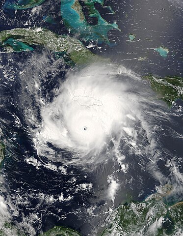
Hurricane Emily was spinning through the Caribbean south of Jamacia on July 16, 2005, when the Moderate Resolution Imaging Spectroradiometer (MODIS) on the Terra satellite captured this image at 15:45 UTC (11:45 a.m. Eastern Daylight Time). At this time, Emily was a well-developed hurricane with winds over 230 kilometers an hour (125 knots) and gusts as high as 285 km/hr (155 knots). As shown in this satellite image, the storm is passing roughly east to west well south of Jamaica (around 160 kilometers, or 100 miles), but the heavy rains in the storm's outer bands fell on an already sodden island still recovering from Hurricane Dennis, which similarly glanced the island on July 7. Emily's rains caused flooding, which has resulted in four deaths on the island. Tourists in the Yucatan Peninsula are being evacuated from resort areas and beaches as the hurricane continues on track to make landfall there during the morning of July 18, 2005. |
|||||
| Dátum | ||||||
| Forrás | http://earthobservatory.nasa.gov/NaturalHazards/natural_hazards_v2.php3?img_id=12967 | |||||
| Szerző | NASA image provided courtesy of Jeff Schmaltz, MODIS Rapid Response team. | |||||
| Engedély (Fájl újrafelhasználása) |
|
|||||
| Más változatok | Image:Hurricane Emily.jpg |

Fájltörténet
Kattints egy időpontra, hogy a fájl akkori állapotát láthasd.
| Dátum/idő | Bélyegkép | Felbontás | Feltöltő | Megjegyzés | |
|---|---|---|---|---|---|
| aktuális | 2023. július 31., 11:44 | | 5 600 × 7 200 (6,25 MB) | Nino Marakot | Reverted to version as of 06:40, 23 July 2018 (UTC) |
| 2018. december 7., 00:56 |  | 6 401 × 8 401 (9,55 MB) | FleurDeOdile | actual center | |
| 2018. július 23., 08:40 |  | 5 600 × 7 200 (6,25 MB) | Nino Marakot | Reverted to version as of 21:47, 2 November 2006 (UTC) | |
| 2018. április 22., 17:43 |  | 1 540 × 1 900 (676 KB) | CooperScience | Larger file, centered, better quality | |
| 2017. május 24., 11:04 |  | 466 × 599 (84 KB) | A1Cafel | clearer | |
| 2006. november 2., 23:47 |  | 5 600 × 7 200 (6,25 MB) | Good kitty | == Summary == {{Information |Description=Hurricane Emily was spinning through the Caribbean south of Jamacia on July 16, 2005, when the Moderate Resolution Imaging Spectroradiometer (MODIS) on the Terra satellite captured this image at 15:45 UTC (11:45 a. |
Fájlhasználat
Az alábbi lapok használják ezt a fájlt:
Globális fájlhasználat
A következő wikik használják ezt a fájlt:
- Használata itt: ca.wikipedia.org
- Használata itt: de.wikipedia.org
- Használata itt: en.wikipedia.org
- Használata itt: eo.wikipedia.org
- Használata itt: es.wikipedia.org
- Használata itt: eu.wikipedia.org
- Használata itt: fi.wikipedia.org
- Használata itt: fr.wikipedia.org
- Használata itt: it.wikipedia.org
- Használata itt: pl.wikipedia.org
- Használata itt: pt.wikipedia.org
- Használata itt: ru.wikipedia.org
- Használata itt: simple.wikipedia.org
- Használata itt: sv.wikipedia.org
- Használata itt: uk.wikipedia.org
- Használata itt: vi.wikipedia.org
- Használata itt: www.wikidata.org
- Használata itt: zh.wikipedia.org