
Fájl:The wars of Matthias Corvinus of Hungary (1458-1490).png

Az előnézet mérete: 597 × 599 képpont További felbontások: 239 × 240 képpont | 478 × 480 képpont | 765 × 768 képpont | 1 020 × 1 024 képpont | 1 700 × 1 707 képpont.
Eredeti fájl (1 700 × 1 707 képpont, fájlméret: 637 KB, MIME-típus: image/png)
|
Ez a fájl a Wikimedia Commonsból származik. Az alább látható leírás az ottani dokumentációjának másolata. A Commons projekt szabad licencű kép- és multimédiatár. Segíts te is az építésében! |
.png)
Összefoglaló
| Leírás |
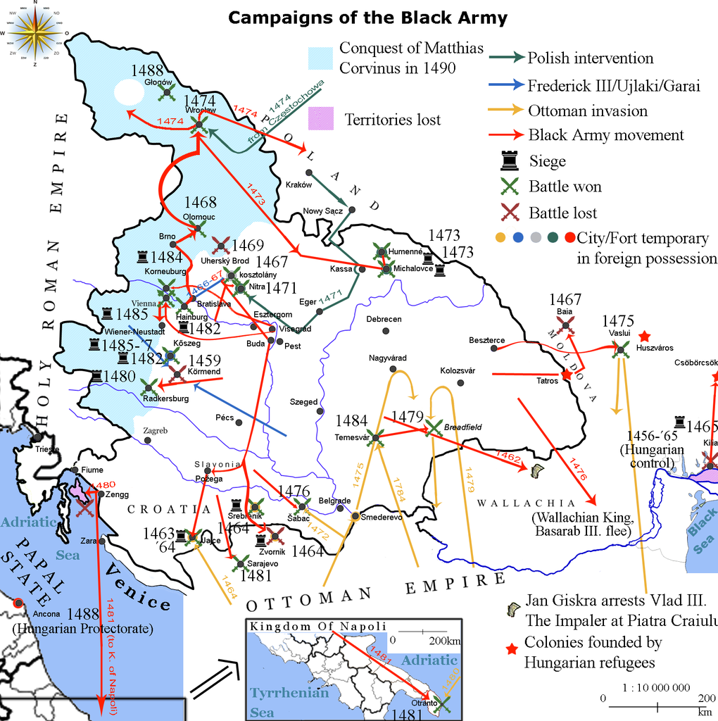
English: Map showing the direction of attacks in/of Hungary and in/of the surrounding countries in the middle of 15th century concentrating on the Black Army of Hungary. |
| Dátum | |
| Forrás | own work based on the map Map of Hungary in 1490. Historical information is taken from Történelmi világatlasz, Budapest, Hungary, 1991, Kartográfiai Vállalat, ISBN 963-351-696-X-CM and Fenyvesi, László (1990). Mátyás Király fekete serege, Budapest, Hungary: Zrínyi Katonai Kiadó. ISBN 9633260170 Érvénytelen ISBN. |
| Szerző | Viztarp (vitalap · szerkesztései), Alex:D (vitalap · szerkesztései) |
Licenc
Lajbi a(z) angol Wikipédia projektből, e mű szerzője a művét az alábbi licenc alatt teszi közzé:
Ez a fájl a Creative Commons Nevezd meg! 3.0 Unported licenc alapján használható fel.
Így nevezd meg: Lajbi a(z) angol Wikipédia projektből
- A következőket teheted a művel:
- megoszthatod – szabadon másolhatod, terjesztheted, bemutathatod és előadhatod a művet
- feldolgozhatod – származékos műveket hozhatsz létre
- Az alábbi feltételekkel:
- Nevezd meg! – A szerzőt megfelelően fel kell tüntetned, hivatkozást kell létrehoznod a licencre és jelezned kell, ha a művön változtatást hajtottál végre. Ezt bármilyen észszerű módon megteheted, kivéve oly módon, ami azt sugallná hogy a jogosult támogat téged vagy a felhasználásod körülményeit.
Eredeti feltöltési napló
Az eredeti leírólap itt volt. Az itt következő felhasználónevek az en.wikipedia projektre hivatkoznak.
| Dátum/idő | Felbontás | Feltöltő | Megjegyzés |
|---|---|---|---|
| 2010-10-20 11:26 | 1700×1707× (652065 bytes) | Lajbi | distinguished Nitra from Kosztolány - corrected Moldvian campaign route |
| 2010-10-19 11:31 | 1700×1707× (649221 bytes) | Lajbi | colored the mini map - fixed the dates - added the HUungarian colonies - added Vlad Tepes' arrest |
| 2010-10-12 21:45 | 1700×1707× (631386 bytes) | Lajbi | Added coast of the Black Sea with the Danube Delta - Colored water - Added "Lost territories" |
| 2010-10-11 16:05 | 1500×1707× (577525 bytes) | Lajbi | *Fixed southern border *Added Battle of Timisosara in 1484 *Added port of Zengg as a starting place for maritine campaigns *Added first Polish intervention *Added northern powlings of Hungarian light cavalry *Added more temporary changes in cities ownersh |
| 2010-10-08 12:50 | 1500×1707× (542278 bytes) | Lajbi | {{Information |Description=Map showing the direction of attacks in/of Hungary and in/of the surrounding countries in the middle of 15th century concentrating on the Black Army of Hungary. |Source=own work based on the map [[File:Map of Hungary in 1490.png |
Fájltörténet
Kattints egy időpontra, hogy a fájl akkori állapotát láthasd.
| Dátum/idő | Bélyegkép | Felbontás | Feltöltő | Megjegyzés | |
|---|---|---|---|---|---|
| aktuális | 2017. február 11., 17:36 | | 1 700 × 1 707 (637 KB) | OgreBot | (BOT): Reverting to most recent version before archival |
| 2017. február 11., 17:36 |  | 1 700 × 1 707 (634 KB) | OgreBot | (BOT): Uploading old version of file from en.wikipedia; originally uploaded on 2010-10-19 11:31:02 by Lajbi | |
| 2017. február 11., 17:36 |  | 1 700 × 1 707 (617 KB) | OgreBot | (BOT): Uploading old version of file from en.wikipedia; originally uploaded on 2010-10-12 21:45:52 by Lajbi | |
| 2017. február 11., 17:36 |  | 1 500 × 1 707 (564 KB) | OgreBot | (BOT): Uploading old version of file from en.wikipedia; originally uploaded on 2010-10-11 16:05:11 by Lajbi | |
| 2017. február 11., 17:36 |  | 1 500 × 1 707 (530 KB) | OgreBot | (BOT): Uploading old version of file from en.wikipedia; originally uploaded on 2010-10-08 12:50:48 by Lajbi | |
| 2017. február 11., 07:50 |  | 1 700 × 1 707 (637 KB) | Jarould | Transferred from en.wikipedia |
Fájlhasználat
Ezt a fájlt nem használja egyetlen lap sem.
Globális fájlhasználat
A következő wikik használják ezt a fájlt:
- Használata itt: ast.wikipedia.org
- Használata itt: azb.wikipedia.org
- Használata itt: da.wikipedia.org
- Használata itt: de.wikipedia.org
- Használata itt: el.wikipedia.org
- Használata itt: en.wikipedia.org
- Használata itt: es.wikipedia.org
- Használata itt: et.wikipedia.org
- Használata itt: fr.wikipedia.org
- Használata itt: he.wikipedia.org
- Használata itt: hr.wikipedia.org
- Használata itt: it.wikipedia.org
- Használata itt: pl.wikipedia.org
- Használata itt: ro.wikipedia.org
- Használata itt: ru.wikipedia.org
- Használata itt: sl.wikipedia.org
- Használata itt: sr.wikipedia.org
- Használata itt: te.wikipedia.org
- Használata itt: th.wikipedia.org
- Használata itt: tr.wikipedia.org
- Használata itt: uk.wikipedia.org
.png)