
Fájl:Eu expansion 2004 map.jpg

Az előnézet mérete: 686 × 599 képpont További felbontások: 275 × 240 képpont | 549 × 480 képpont | 879 × 768 képpont | 1 124 × 982 képpont.
Eredeti fájl (1 124 × 982 képpont, fájlméret: 1,27 MB, MIME-típus: image/jpeg)
|
Ez a fájl a Wikimedia Commonsból származik. Az alább látható leírás az ottani dokumentációjának másolata. A Commons projekt szabad licencű kép- és multimédiatár. Segíts te is az építésében! |
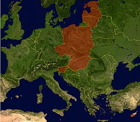
- Description: Countries that joined the European Union in May 2004. Satellite-map of Europe incl. borders with color overlay.
- Source: NASA World Wind (public domain), color-overlay by WLuef.
| This image is in the public domain because it is a screenshot from NASA’s globe software World Wind using a public domain layer, such as Blue Marble, MODIS, Landsat, SRTM, USGS or GLOBE.
|
 |
Fájltörténet
Kattints egy időpontra, hogy a fájl akkori állapotát láthasd.
| Dátum/idő | Bélyegkép | Felbontás | Feltöltő | Megjegyzés | |
|---|---|---|---|---|---|
| aktuális | 2006. február 18., 13:15 | | 1 124 × 982 (1,27 MB) | WL~commonswiki | * Description: Countries that joined the European Union in May 2004. Satellite-map of Europe incl. borders with color overlay. * Source: NASA World Wind (public domain), color-overlay by user. |
| 2005. március 25., 15:26 |  | 1 124 × 982 (1,25 MB) | WL~commonswiki | satellite-map of Europe incl. borders from NASA World Wind (public domain), color-overlay by WLuef. |
Fájlhasználat
Az alábbi lap használja ezt a fájlt:
Globális fájlhasználat
A következő wikik használják ezt a fájlt:
- Használata itt: de.wikipedia.org
- Használata itt: de.wiktionary.org