
Fájl:Erzurum districts.png
Az előnézet mérete: 776 × 600 képpont További felbontások: 311 × 240 képpont | 621 × 480 képpont | 994 × 768 képpont | 1 056 × 816 képpont.
Eredeti fájl (1 056 × 816 képpont, fájlméret: 38 KB, MIME-típus: image/png)
|
Ez a fájl a Wikimedia Commonsból származik. Az alább látható leírás az ottani dokumentációjának másolata. A Commons projekt szabad licencű kép- és multimédiatár. Segíts te is az építésében! |
Összefoglaló
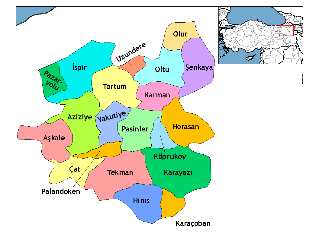
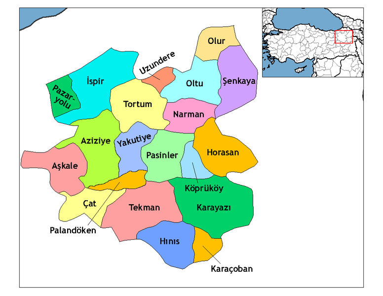
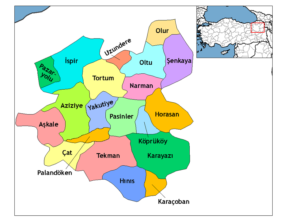
| Leírás | Map of the districts of Erzurum province in Turkey. Created by Rarelibra 19:53, 1 December 2006 (UTC) for public domain use, using MapInfo Professional v8.5 and various mapping resources. Edited by One Homo Sapiens Corrected text where İ,Ş,ı,ğ,or ş occurs in name. Source: [statoids-com]. Increased font size and enhanced color differences among adjacent districts. |
| Dátum | 2006. december 1. (eredeti feltöltésének dátuma) |
| Forrás | Nincs megadva géppel olvasható forrás. Feltételezhetően saját munka (a szerzői jogi adatok alapján). |
| Szerző | Nincs megadva géppel olvasható szerző. Feltételezhetően Rarelibra (a szerzői jogi adatok alapján). |
Licenc
| Én, a szerző, ezt a művemet ezennel közkinccsé nyilvánítom. Ez a világ minden részén érvényes. Egyes országokban ez jogilag nem lehetséges. Ha így van, akkor: Jogot adok bárkinek, hogy bármilyen célból, feltétel nélkül használhassa ezt a fájlt, kivéve a törvény által kötelezően előírt feltételeket. |
Fájltörténet
Kattints egy időpontra, hogy a fájl akkori állapotát láthasd.
| Dátum/idő | Bélyegkép | Felbontás | Feltöltő | Megjegyzés | |
|---|---|---|---|---|---|
| aktuális | 2009. április 18., 04:52 | | 1 056 × 816 (38 KB) | One Homo Sapiens | Added Aziziye, Palandöken and Yakutiye, that replaced Erzurum merkezi and Ilıca districts. Source: << www.erzurum.gov.tr >> |
| 2008. december 29., 00:20 |  | 1 056 × 816 (41 KB) | One Homo Sapiens | Corrected text where İ,Ş,ı,ğ,or ş occurs in name. Source: [statoids-com]. Increased font size and enhanced color differences among adjacent districts. | |
| 2006. december 1., 21:53 |  | 1 056 × 816 (35 KB) | Rarelibra | Map of the districts of Erzurum province in Turkey. Created by ~~~~ for public domain use, using MapInfo Professional v8.5 and various mapping resources. |
Fájlhasználat
Az alábbi lap használja ezt a fájlt:
Globális fájlhasználat
A következő wikik használják ezt a fájlt:
- Használata itt: ar.wikipedia.org
- Használata itt: arz.wikipedia.org
- Használata itt: ast.wikipedia.org
- Használata itt: azb.wikipedia.org
- Használata itt: ba.wikipedia.org
- Használata itt: bs.wikipedia.org
- Használata itt: ca.wikipedia.org
- Használata itt: cs.wikipedia.org
- Használata itt: de.wikipedia.org
- Használata itt: diq.wikipedia.org
- Használata itt: en.wikipedia.org
A fájl globális használatának megtekintése