
Fájl:ElectoralCollege2000-Large.png
Az előnézet mérete: 800 × 430 képpont További felbontások: 320 × 172 képpont | 640 × 344 képpont | 1 182 × 635 képpont.
Eredeti fájl (1 182 × 635 képpont, fájlméret: 175 KB, MIME-típus: image/png)
|
Ez a fájl a Wikimedia Commonsból származik. Az alább látható leírás az ottani dokumentációjának másolata. A Commons projekt szabad licencű kép- és multimédiatár. Segíts te is az építésében! |
| U.S. presidential election maps from the National Atlas of the United States |
| See also: SVG maps |
| 1789 · 1792 · 1796 · 1800 · 1804 · 1808 · 1812 · 1816 · 1820 · 1824 · 1828 · 1832 · 1836 · 1840 · 1844 · 1848 · 1852 · 1856 · 1860 · 1864 · 1868 · 1872 · 1876 · 1880 · 1884 · 1888 · 1892 · 1896 · 1900 · 1904 · 1908 · 1912 · 1916 · 1920 · 1924 · 1928 · 1932 · 1936 · 1940 · 1944 · 1948 · 1952 · 1956 · 1960 · 1964 · 1968 · 1972 · 1976 · 1980 · 1984 · 1988 · 1992 · 1996 · 2000 · 2004 |
Összefoglaló
| Leírás |
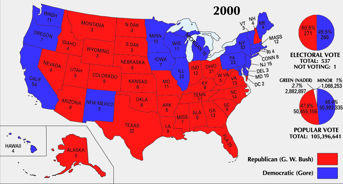
English: 2000 Electoral College Map |
|||
| Forrás | https://nationalmap.gov/small_scale/printable/elections.html | |||
| Szerző | United States Geological Survey | |||
| Más változatok |
|


Licenc
This map was obtained from an edition of the National Atlas of the United States. Like almost all works of the U.S. federal government, works from the National Atlas are in the public domain in the United States.
Online access: NationalAtlas.gov | 1970 print edition: Library of Congress, Perry-Castañeda Library
|
Fájltörténet
Kattints egy időpontra, hogy a fájl akkori állapotát láthasd.
| Dátum/idő | Bélyegkép | Felbontás | Feltöltő | Megjegyzés | |
|---|---|---|---|---|---|
| aktuális | 2008. június 26., 01:51 | | 1 182 × 635 (175 KB) | Tallicfan20 | better resolution |
| 2008. február 14., 03:02 |  | 1 182 × 635 (83 KB) | SteveSims~commonswiki | Reverted to version as of 10:23, 25 July 2007. The version with Nader as green didn't look very good. | |
| 2008. február 8., 00:08 |  | 1 182 × 635 (2,15 MB) | SteveSims~commonswiki | Ralph Nader's popular votes made green. Also public domain. | |
| 2007. július 25., 12:23 |  | 1 182 × 635 (83 KB) | Cardsplayer4life~commonswiki | Reverted to earlier revision | |
| 2007. július 25., 11:46 |  | 1 182 × 635 (62 KB) | Joseph Solis in Australia~commonswiki | {{PD-USGov-Atlas}} Category:2000 {{US presidential election maps}} | |
| 2007. július 2., 04:30 |  | 1 182 × 635 (83 KB) | Cardsplayer4life~commonswiki | {{PD-USGov-Atlas}} Source: EN Wiki {{US presidential election maps}} | |
| 2007. június 29., 12:08 |  | 1 182 × 635 (62 KB) | Joseph Solis in Australia~commonswiki | {{PD-USGov-Atlas}} Category:2000 {{US presidential election maps}} | |
| 2007. június 21., 23:04 |  | 1 182 × 635 (83 KB) | Cardsplayer4life~commonswiki | {{PD-USGov-Atlas}} Category:2000 {{US presidential election maps}} | |
| 2005. augusztus 19., 12:21 |  | 1 182 × 635 (62 KB) | Ondrejk | {{PD-USGov-Atlas}} Source: EN Wiki |
Fájlhasználat
Ezt a fájlt nem használja egyetlen lap sem.
Globális fájlhasználat
A következő wikik használják ezt a fájlt:
- Használata itt: el.wikipedia.org
- Használata itt: en.wikipedia.org
- Használata itt: fa.wikipedia.org
- Használata itt: sv.wikipedia.org
- Használata itt: uk.wikipedia.org