
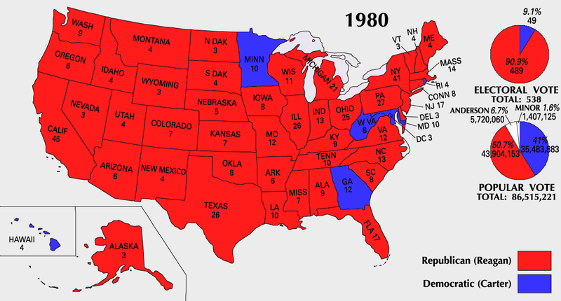
Fájl:ElectoralCollege1980-Large.png

Az előnézet mérete: 800 × 430 képpont További felbontások: 320 × 172 képpont | 640 × 344 képpont | 1 182 × 635 képpont.
Eredeti fájl (1 182 × 635 képpont, fájlméret: 166 KB, MIME-típus: image/png)
|
Ez a fájl a Wikimedia Commonsból származik. Az alább látható leírás az ottani dokumentációjának másolata. A Commons projekt szabad licencű kép- és multimédiatár. Segíts te is az építésében! |
| U.S. presidential election maps from the National Atlas of the United States |
| See also: SVG maps |
| 1789 · 1792 · 1796 · 1800 · 1804 · 1808 · 1812 · 1816 · 1820 · 1824 · 1828 · 1832 · 1836 · 1840 · 1844 · 1848 · 1852 · 1856 · 1860 · 1864 · 1868 · 1872 · 1876 · 1880 · 1884 · 1888 · 1892 · 1896 · 1900 · 1904 · 1908 · 1912 · 1916 · 1920 · 1924 · 1928 · 1932 · 1936 · 1940 · 1944 · 1948 · 1952 · 1956 · 1960 · 1964 · 1968 · 1972 · 1976 · 1980 · 1984 · 1988 · 1992 · 1996 · 2000 · 2004 |
Összefoglaló
| Leírás |
English: 1980 Electoral College Map |
| Forrás | https://nationalmap.gov/small_scale/printable/elections.html |
| Szerző | United States Geological Survey |

|
Ezt a képet el kellene készíteni vektorgrafika használatával SVG fájlként. A formátumnak számos előnye van; lásd a Commons:Media for cleanup lapot a további információkért. Ha a képnek már elérhető SVG-formátumú változata, töltsd fel. Az SVG feltöltése után cseréld le ezt a sablont a következőre: {{vector version available|új kép neve.svg}}.
|
Licenc
This map was obtained from an edition of the National Atlas of the United States. Like almost all works of the U.S. federal government, works from the National Atlas are in the public domain in the United States.
Online access: NationalAtlas.gov | 1970 print edition: Library of Congress, Perry-Castañeda Library
|
Fájltörténet
Kattints egy időpontra, hogy a fájl akkori állapotát láthasd.
| Dátum/idő | Bélyegkép | Felbontás | Feltöltő | Megjegyzés | |
|---|---|---|---|---|---|
| aktuális | 2007. július 25., 12:18 | | 1 182 × 635 (166 KB) | Cardsplayer4life~commonswiki | Reverted to earlier revision |
| 2007. július 25., 11:34 |  | 1 182 × 635 (107 KB) | Joseph Solis in Australia~commonswiki | {{PD-USGov-Atlas}} Category:1980 {{US presidential election maps}} | |
| 2007. július 9., 03:44 |  | 1 182 × 635 (166 KB) | Cardsplayer4life~commonswiki | {{PD-USGov-Atlas}} {{US presidential election maps}} | |
| 2007. július 6., 11:38 |  | 1 182 × 635 (107 KB) | Joseph Solis in Australia~commonswiki | {{PD-USGov-Atlas}} Category:1980 {{US presidential election maps}} | |
| 2007. július 2., 04:28 |  | 1 182 × 635 (166 KB) | Cardsplayer4life~commonswiki | {{PD-USGov-Atlas}} {{US presidential election maps}} | |
| 2007. június 29., 12:16 |  | 1 182 × 635 (107 KB) | Joseph Solis in Australia~commonswiki | {{PD-USGov-Atlas}} Category:1980 {{US presidential election maps}} | |
| 2007. június 21., 23:07 |  | 1 182 × 635 (166 KB) | Cardsplayer4life~commonswiki | {{PD-USGov-Atlas}} Category:1980 {{US presidential election maps}} | |
| 2007. május 31., 10:31 |  | 1 182 × 635 (107 KB) | Joseph Solis in Australia~commonswiki | {{PD-USGov-Atlas}} {{US presidential election maps}} | |
| 2006. május 25., 22:05 |  | 1 182 × 635 (94 KB) | JP06035 | switched colors | |
| 2006. január 22., 18:08 |  | 1 182 × 635 (107 KB) | Red devil 666 | {{PD-USGov-Atlas}} |
Fájlhasználat
Az alábbi lap használja ezt a fájlt:
Globális fájlhasználat
A következő wikik használják ezt a fájlt:
- Használata itt: cs.wikipedia.org
- Használata itt: da.wikipedia.org
- Használata itt: en.wikipedia.org
- Használata itt: fi.wikipedia.org
- Használata itt: fr.wikipedia.org
- Használata itt: it.wikipedia.org
- Használata itt: nl.wikipedia.org
- Használata itt: uk.wikipedia.org
- Használata itt: vi.wikipedia.org