
Fájl:Disturnell & Schroeter Map Illustrating the Disputed Boundary Between the United States and Mexico 1853 UTA.jpg

Az előnézet mérete: 800 × 468 képpont További felbontások: 320 × 187 képpont | 640 × 375 képpont | 1 024 × 599 képpont | 1 280 × 749 képpont | 2 560 × 1 498 képpont | 4 188 × 2 451 képpont.
Eredeti fájl (4 188 × 2 451 képpont, fájlméret: 1,24 MB, MIME-típus: image/jpeg)
|
Ez a fájl a Wikimedia Commonsból származik. Az alább látható leírás az ottani dokumentációjának másolata. A Commons projekt szabad licencű kép- és multimédiatár. Segíts te is az építésében! |
Összefoglaló
| Cím |
English: Map illustrating the Disputed Boundary between the United States and Mexico |
||||||||||||||||||||||||||
| Leírás |
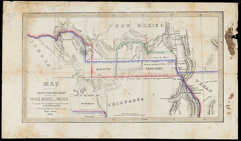
English: Soon after the U.S. and Mexican Boundary Commissions began their surveys in 1849, they noted glaring errors on the 1847 map that had been used to negotiate the Treaty of Guadalupe Hidalgo. The town of El Paso, and thus the boundary itself, had been situated too far to the north on the map, resulting in disagreements between the United States and Mexican governments over exactly where the boundary should be. The New York publisher of the original treaty map, John Disturnell, later issued this map to correct the earlier errors and to illustrate the disputed boundary lines that had resulted (the red for the U.S. claim and the blue for Mexico's). Also, as shown, Americans had learned that even with the corrections in latitude, one of the best routes to California – Cooke's Wagon Road – actually lay south of the new border, and a large lobby of U.S. citizens wanted the land to construct a railroad from El Paso to the Pacific. Given the Mexican government's need for cash, on December 30, 1853, U.S. and Mexican diplomats signed the Gadsden Purchase treaty, whereby the United States paid Mexico $10 million for 29,142,400 acres of a wedge of land within the present states of New Mexico and Arizona. |
||||||||||||||||||||||||||
| Dátum | |||||||||||||||||||||||||||
| Forrás | UTA Libraries Cartographic Connections: térkép / text | ||||||||||||||||||||||||||
| Alkotó |
|
||||||||||||||||||||||||||
| Származás |
English: UTA Libraries Special Collections |
||||||||||||||||||||||||||
| Geotemporal data | |||||||||||||||||||||||||||
| Map location |
Amerikai Egyesült Államok Mexikó |
||||||||||||||||||||||||||
| Georeferencing | If inappropriate please set warp_status = skip to hide. | ||||||||||||||||||||||||||
| Bibliographic data | |||||||||||||||||||||||||||
| Kiadás helye | New York | ||||||||||||||||||||||||||
| Nyomda |
|
||||||||||||||||||||||||||
| Archival data | |||||||||||||||||||||||||||
| Gyűjtemény |
|
||||||||||||||||||||||||||
| Méretei | magasság: 22,5 cm; szélesség: 40 cm | ||||||||||||||||||||||||||
| Technika | színezett litográfia (kőnyomat) | ||||||||||||||||||||||||||
| artwork-references | Wheat Mapping the Trans-Mississippi West, 3, no. 779 , 236, 325 o. | ||||||||||||||||||||||||||
Licenc

|
This file was provided to Wikimedia Commons by the University of Texas at Arlington Libraries as part of a cooperation project. The University of Texas at Arlington Libraries is part of the University of Texas at Arlington, a public research university located in Arlington, Texas.
|
|
A szerző halálozási ideje 1877, ezért ez a mű közkincs abban az országban, ahol elkészítették, és minden olyan további államban, ahol a szerzői jogi védelmi idő a szerző élete plusz 100 év vagy kevesebb. Ez az alkotás az Amerikai Egyesült Államokban közkincsnek számít, mivel 1929. január 1. előtt publikálták. | |
| Megállapították, hogy ez a fájl mentes mindenféle szerzői jogi korlátozástól, beleértve az összes kapcsolódó és hozzátartozó jogot. | |
Fájltörténet
Kattints egy időpontra, hogy a fájl akkori állapotát láthasd.
| Dátum/idő | Bélyegkép | Felbontás | Feltöltő | Megjegyzés | |
|---|---|---|---|---|---|
| aktuális | 2022. március 12., 20:50 | | 4 188 × 2 451 (1,24 MB) | Michael Barera | == {{int:filedesc}} == {{Map |title = {{en|'''''Map illustrating the Disputed Boundary between the United States and Mexico'''''}} |description = {{en|Soon after the U.S. and Mexican Boundary Commissions began their surveys in 1849, they noted glaring errors on the 1847 map that had been used to negotiate the Treaty of Guadalupe Hidalgo. The town of El Paso, and thus the boundary itself, had been situated too far to the north on the map, resulting in disagreements between... |
Fájlhasználat
Az alábbi lap használja ezt a fájlt:
Globális fájlhasználat
A következő wikik használják ezt a fájlt:
- Használata itt: de.wikipedia.org
- Használata itt: es.wikipedia.org
- Használata itt: fr.wikipedia.org
- Használata itt: ko.wikipedia.org